File:1900_Electoral_Map.png
From Wikipedia, the free encyclopedia
Størrelse på denne forhåndsvisningen: 800 × 430 piksler. Andre oppløsninger: 320 × 172 piksler | 640 × 344 piksler | 1 182 × 635 piksler.
Opprinnelig fil (1 182 × 635 piksler, filstørrelse: 177 KB, MIME-type: image/png)
| Denne filen er fra Wikimedia Commons og kan brukes av andre prosjekter. Informasjonen fra filbeskrivelsessiden vises nedenfor. |
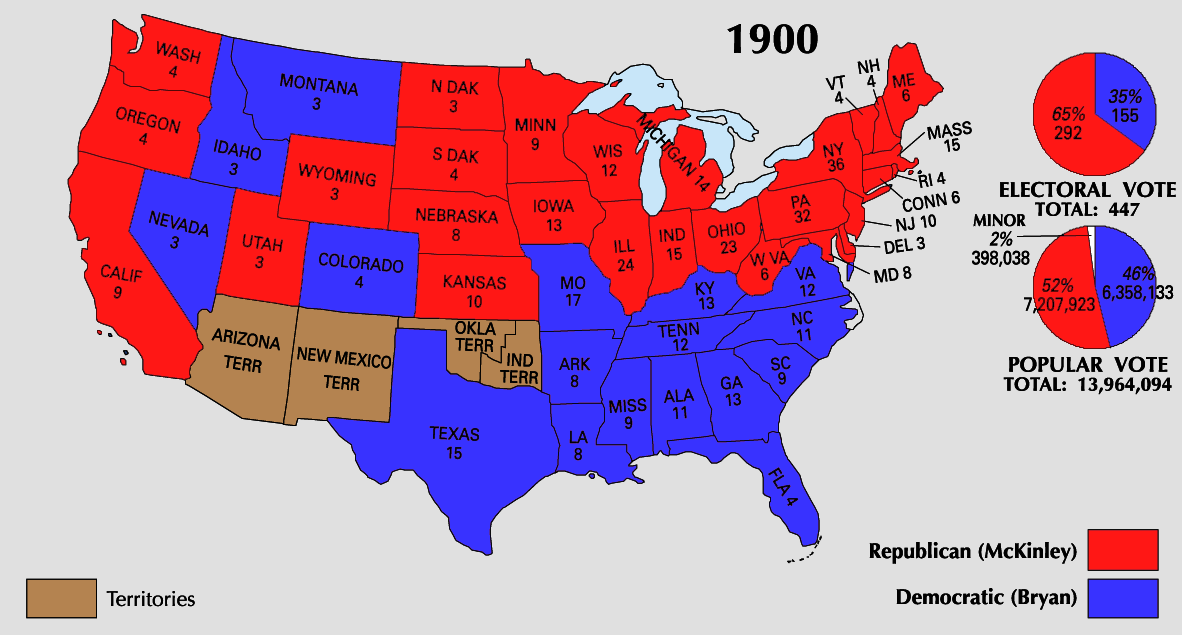
| U.S. presidential election maps from the National Atlas of the United States |
| See also: SVG maps |
| 1789 · 1792 · 1796 · 1800 · 1804 · 1808 · 1812 · 1816 · 1820 · 1824 · 1828 · 1832 · 1836 · 1840 · 1844 · 1848 · 1852 · 1856 · 1860 · 1864 · 1868 · 1872 · 1876 · 1880 · 1884 · 1888 · 1892 · 1896 · 1900 · 1904 · 1908 · 1912 · 1916 · 1920 · 1924 · 1928 · 1932 · 1936 · 1940 · 1944 · 1948 · 1952 · 1956 · 1960 · 1964 · 1968 · 1972 · 1976 · 1980 · 1984 · 1988 · 1992 · 1996 · 2000 · 2004 |
Beskrivelse


Lisensiering
| Public domainPublic domainfalsefalse |
This map was obtained from an edition of the National Atlas of the United States. Like almost all works of the U.S. federal government, works from the National Atlas are in the public domain in the United States.
Online access: NationalAtlas.gov | 1970 print edition: Library of Congress, Perry-Castañeda Library čeština | Deutsch | English | français | Bahasa Indonesia | italiano | македонски | മലയാളം | sicilianu | 中文 | 中文(简体) | 中文(繁體) | +/− |
Bildetekster
Legg til en kort forklaring på hva filen representerer
Elementer som er med i denne fila
motiv
image/png
c3e47589fe0830cc04f228b795992944b31b06c2
181 182 byte
635 piksel
1 182 piksel
Filhistorikk
Klikk på et tidspunkt for å vise filen slik den var på det tidspunktet.
| Dato/klokkeslett | Miniatyrbilde | Dimensjoner | Bruker | Kommentar | |
|---|---|---|---|---|---|
| nåværende | 26. jun. 2008 kl. 00:35 | | 1 182 × 635 (177 KB) | Tallicfan20 | |
| 24. jun. 2008 kl. 06:51 |  | 1 182 × 635 (157 KB) | Tallicfan20 | ||
| 26. mai 2008 kl. 00:40 |  | 1 182 × 635 (147 KB) | Tallicfan20 | better quality | |
| 17. mai 2008 kl. 06:56 |  | 1 182 × 635 (101 KB) | Tallicfan20 | {{PD-USGov-Atlas}} |
Filbruk
Det er ingen sider som bruker denne filen.
Global filbruk
Følgende andre wikier bruker denne filen:
- Bruk i de.wikipedia.org
- Bruk i en.wikipedia.org
- Bruk i sv.wikipedia.org
- Bruk i vi.wikipedia.org
- Bruk i zh.wikipedia.org
Metadata
Denne filen inneholder tilleggsinformasjon, sannsynligvis lagt til av digitalkameraet eller skanneren som ble brukt til å lage eller digitalisere det.
Hvis filen har blitt forandret fra utgangspunktet, kan enkelte detaljer være unøyaktige.
| Horisontal oppløsning | 28,35 dpc |
|---|---|
| Vertikal oppløsning | 28,35 dpc |