File:Kingdoms_of_the_Levant_Map_830.xcf
From Wikipedia, the free encyclopedia
Størrelse for denne PNG-forhåndsvisningen av denne XCF-filen: 503 × 600 piksler Andre oppløsninger: 201 × 240 piksler | 402 × 480 piksler | 644 × 768 piksler | 858 × 1 024 piksler | 1 955 × 2 332 piksler.
Opprinnelig fil (1 955 × 2 332 piksler, filstørrelse: 941 KB, MIME-type: image/x-xcf)
| Denne filen er fra Wikimedia Commons og kan brukes av andre prosjekter. Informasjonen fra filbeskrivelsessiden vises nedenfor. |
|
Denne XCF rastergrafikken ble laget med GIMP.
|
Beskrivelse
| BeskrivelseKingdoms of the Levant Map 830.xcf |
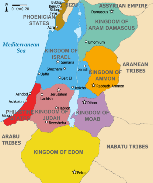
English: Map showing Kingdoms of the Levant c 830. The Kingdoms:
العربية: خريطة توضح ممالك بلاد الشام ج 830. الممالك:
فينيقيا - بني ارام دمشق - زبرجد آمون - البرتقالي موآب - بنفسجي ايدوم - الأصفر فلسطين - أحمر يهوذا - مارون تُظهر الخريطة المنطقة في القرن التاسع قبل الميلاد. |
| Dato | (UTC) |
| Kilde |
This file was derived from: |
| Opphavsperson |
|
| Andre versjoner | Derivative works of this file: Kingdoms of the Levant Map 830.png |


| This is a retouched picture, which means that it has been digitally altered from its original version. Modifications: Added colours for the two kingdoms. The original can be viewed here: Kingdoms of Israel and Judah map 830.svg:
|
Lisensiering
Denne filen er lisensiert under lisensen Creative Commons Navngivelse-DelPåSammeVilkår 3.0 Unported
- Du står fritt:
- til å dele – til å kopiere, distribuere og overføre verket
- til å blande – til å endre verket
- Under de følgende betingelsene:
- navngivelse – Du må kreditere verket på passende vis, lenke til lisensen og indikere hvorvidt det har blitt gjort endringer. Du kan gjøre det på enhver rimelig måte, men ikke på en måte som antyder at lisensgiveren støtter deg eller din bruk av verket.
- del på samme vilkår – Dersom du remikser, omarbeider eller på annen måte bygger på dette verket, må du kun distribuere resultatet under den samme eller en samsvarende lisens som denne.
Orginal opplastningslogg
This image is a derivative work of the following images:
- File:Kingdoms_around_Israel_830_map.svg licensed with Cc-by-sa-3.0, GFDL
- 2010-07-13T12:58:31Z Richardprins 720x859 (169373 Bytes) livened up the colors, converted med sea text to path
- 2010-07-13T11:26:40Z Richardprins 720x859 (141985 Bytes) {{Information |Description={{en|1=Map showing the ancient levant borders and ancient cities such as [[Urmomium]] and [[Jerash]]. The Kingdoms around Israel and Judah are colored. The map also shows the region in the 9th centu
- File:Kingdoms_of_Israel_and_Judah_map_830.svg licensed with Cc-by-sa-3.0, GFDL
- 2011-02-12T23:48:05Z Richardprins 720x859 (80190 Bytes) -
- 2010-07-13T11:29:47Z Richardprins 720x859 (80899 Bytes) Fixed Judah color
- 2010-07-13T10:51:49Z Richardprins 720x859 (80858 Bytes) Added colors for the two kingdoms and converted their text to path and arial
- 2010-07-12T23:53:35Z Richardprins 720x859 (63843 Bytes) Shrinked down the borders
- 2010-07-12T19:43:31Z Richardprins 720x859 (63800 Bytes) {{Information |Description={{en|1=Map showing the ancient levant borders and ancient cities such as [[Urmomium]] and [[Jerash]]. The map also shows the region in the 9th century BCE. Notice the coastal land of Philistia, from
Uploaded with derivativeFX
Bildetekster
Legg til en kort forklaring på hva filen representerer
Elementer som er med i denne fila
motiv
12. mar. 2012
image/x-xcf
Filhistorikk
Klikk på et tidspunkt for å vise filen slik den var på det tidspunktet.
| Dato/klokkeslett | Miniatyrbilde | Dimensjoner | Bruker | Kommentar | |
|---|---|---|---|---|---|
| nåværende | 12. mar. 2012 kl. 13:26 |  | 1 955 × 2 332 (941 KB) | Dlv999 | == {{int:filedesc}} == {{Information |Description={{en|1=Map showing Kingdoms of the Levant c 830. The Kingdoms: * Phoenicia -Brown * Aram Damascus - Aquamarine * Amon - Orange * Moab - Purple * Edom - Yellow * Philistia - Red * Israel - Blue) *... |
Filbruk
Det er ingen sider som bruker denne filen.
Global filbruk
Følgende andre wikier bruker denne filen:
- Bruk i ar.wikipedia.org
- Bruk i en.wikipedia.org
- Bruk i hr.wikipedia.org
- Bruk i mg.wikipedia.org