Fil:Operation_Dragoon_-_map.jpg
From Wikipedia, the free encyclopedia
Opprinnelig fil (1 265 × 965 piksler, filstørrelse: 1,94 MB, MIME-type: image/jpeg)
| Denne filen er fra Wikimedia Commons og kan brukes av andre prosjekter. Informasjonen fra filbeskrivelsessiden vises nedenfor. |

|
Dette bildet bør gjenskapes med hjelp av vektorgrafikk som en SVG-fil. Dette har flere fordeler, se Commons:Media for cleanup for mer informasjon. Hvis en SVG-fil med dette bildet er tilgjengelig, vennligst last den opp. Etter opplasting erstatt denne malen med {{vector version available|nytt bilde.svg}}.
|
 | This military map image was uploaded in the JPEG format even though it consists of non-photographic data. This information could be stored more efficiently or accurately in the PNG or SVG format. If possible, please upload a PNG or SVG version of this image without compression artifacts, derived from a non-JPEG source (or with existing artifacts removed). After doing so, please tag the JPEG version with {{Superseded|NewImage.ext}} and remove this tag. This tag should not be applied to photographs or scans. If this image is a diagram or other image suitable for vectorisation, please tag this image with {{Convert to SVG}} instead of {{BadJPEG}}. If not suitable for vectorisation, use {{Convert to PNG}}. For more information, see {{BadJPEG}}. |  |
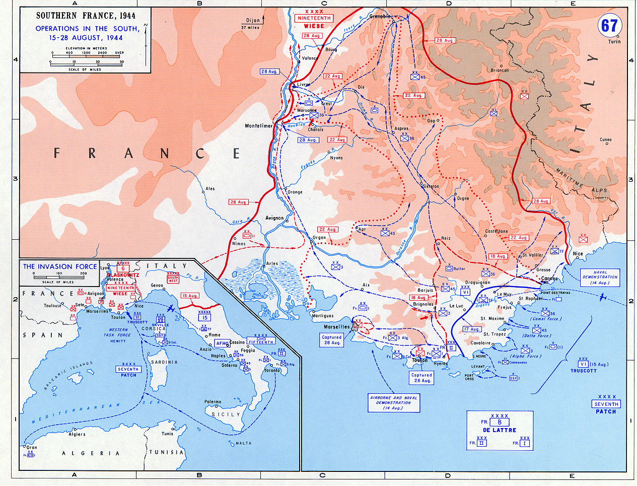
- Description: Operation Dragoon - Aug. 1944
- Source: www.dean.usma.edu
- Background information:
In 1938 the predecessors of what is today The Department of History at the United States Military Academy began developing a series of campaign atlases to aid in teaching cadets a course entitled, "History of the Military Art." Since then, the Department has produced over six atlases and more than one thousand maps, encompassing not only America’s wars but global conflicts as well.
In keeping abreast with today's technology, the Department of History is providing these maps on the internet as part of the department's outreach program. The maps were created by the United States Military Academy’s Department of History and are the digital versions from the atlases printed by the United States Defense Printing Agency. We gratefully acknowledge the accomplishments of the department's former cartographer, Mr. Edward J. Krasnoborski, along with the works of our present cartographer, Mr. Frank Martini.
Please be aware that these maps are large in file size and may require substantial download times.
Notes
- The indication "Dijon 37 miles" in the top middle of the map is most likely an error and should read "Lyon 37 miles".
| Public domainPublic domainfalsefalse |
This file is a work of a U.S. Army soldier or employee, taken or made as part of that person's official duties. As a work of the U.S. federal government, it is in the public domain in the United States.
العربية ∙ বাংলা ∙ català ∙ čeština ∙ Deutsch ∙ English ∙ español ∙ eesti ∙ فارسی ∙ suomi ∙ français ∙ hrvatski ∙ magyar ∙ Bahasa Indonesia ∙ italiano ∙ 日本語 ∙ 한국어 ∙ lietuvių ∙ македонски ∙ മലയാളം ∙ မြန်မာဘာသာ ∙ Nederlands ∙ polski ∙ português ∙ русский ∙ sicilianu ∙ српски / srpski ∙ Türkçe ∙ українська ∙ Tiếng Việt ∙ 中文(简体) ∙ 中文(繁體) ∙ +/− |
 |
Bildetekster
Elementer som er med i denne fila
motiv
Filhistorikk
Klikk på et tidspunkt for å vise filen slik den var på det tidspunktet.
| Dato/klokkeslett | Miniatyrbilde | Dimensjoner | Bruker | Kommentar | |
|---|---|---|---|---|---|
| nåværende | 23. mai 2018 kl. 18:50 | | 1 265 × 965 (1,94 MB) | Hohum | Colour adjust |
| 14. sep. 2005 kl. 19:53 |  | 1 265 × 965 (1,93 MB) | W.wolny |
Filbruk
Den følgende siden bruker denne filen:
Global filbruk
Følgende andre wikier bruker denne filen:
- Bruk i azb.wikipedia.org
- Bruk i bg.wikipedia.org
- Bruk i ca.wikipedia.org
- Bruk i cs.wikipedia.org
- Bruk i da.wikipedia.org
- Bruk i de.wikipedia.org
- Bruk i el.wikipedia.org
- Bruk i en.wikipedia.org
- Bruk i eo.wikipedia.org
- Bruk i es.wikipedia.org
- Bruk i fa.wikipedia.org
- Bruk i fi.wikipedia.org
- Bruk i fr.wikipedia.org
- Bruk i he.wikipedia.org
- Bruk i hu.wikipedia.org
- Bruk i id.wikipedia.org
- Bruk i it.wikipedia.org
- Bruk i ja.wikipedia.org
- Bruk i ko.wikipedia.org
- Bruk i nl.wikipedia.org
- Bruk i pl.wikipedia.org
- Bruk i ro.wikipedia.org
- Bruk i ru.wikipedia.org
- Bruk i sh.wikipedia.org
- Bruk i sk.wikipedia.org
- Bruk i sl.wikipedia.org
- Bruk i sv.wikipedia.org
- Bruk i ta.wikipedia.org
- Bruk i th.wikipedia.org
- Bruk i tr.wikipedia.org
- Bruk i uk.wikipedia.org
- Bruk i www.wikidata.org
- Bruk i zh.wikipedia.org
Metadata
Denne filen inneholder tilleggsinformasjon, sannsynligvis lagt til av digitalkameraet eller skanneren som ble brukt til å lage eller digitalisere det.
Hvis filen har blitt forandret fra utgangspunktet, kan enkelte detaljer være unøyaktige.
| Bildetittel | File written by Adobe Photoshop? 5.2 |
|---|---|
| Brukerkommentarer | File written by Adobe Photoshop? 5.2 |
| Horisontal oppløsning | 100 dpi |
| Vertikal oppløsning | 100 dpi |
| Programvare brukt | GIMP 2.10.0 |
| Dato og tid for filendring | 23. mai 2018 kl. 17:49 |
| Unik ID for originaldokumentet | xmp.did:102f09f9-1032-4166-8349-e0bfe65f985a |