Fil:Map_amutka.gif
From Wikipedia, the free encyclopedia
Map_amutka.gif (500 × 414 pikslar, filstorleik: 104 KB, MIME-type: image/gif)
Denne fila er frå Wikimedia Commons og kan verta nytta av andre prosjekt. Skildringa frå filskildringssida der er vist nedanfor.
Følgjande er henta frå filomtalen åt denne fila på Wikimedia Commons:
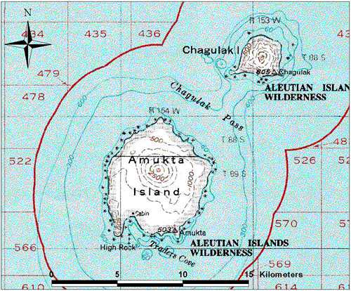
Map of Amukta Island in Alaska, USA Modified from USGS 1:250000 scale topographic geotiff files.
| Public domainPublic domainfalsefalse |
This image is in the public domain in the United States because it only contains materials that originally came from the United States Geological Survey, an agency of the United States Department of the Interior. For more information, see the official USGS copyright policy.
Bahasa Indonesia ∙ català ∙ čeština ∙ Deutsch ∙ eesti ∙ English ∙ español ∙ français ∙ galego ∙ italiano ∙ Nederlands ∙ português ∙ polski ∙ sicilianu ∙ suomi ∙ Tiếng Việt ∙ Türkçe ∙ български ∙ македонски ∙ русский ∙ മലയാളം ∙ 한국어 ∙ 日本語 ∙ 中文 ∙ 中文(简体) ∙ 中文(繁體) ∙ العربية ∙ فارسی ∙ +/− |
Filhistorikk
Klikk på dato/klokkeslett for å sjå fila slik ho var på det tidspunktet.
| Dato/klokkeslett | Miniatyrbilete | Oppløysing | Brukar | Kommentar | |
|---|---|---|---|---|---|
| gjeldande | 2. februar 2005 kl. 14:16 | | 500 × 414 (104 KB) | GarciaB~commonswiki | Map of Amutka Island in Alaska, USA |
Filbruk
Den følgjande sida bruker denne fila:
Global filbruk
Desse andre wikiane nyttar fila:
- Bruk på ca.wikipedia.org
- Bruk på en.wikipedia.org
- Bruk på id.wikipedia.org
- Bruk på ms.wikipedia.org
- Bruk på nl.wikipedia.org
- Bruk på zh.wikipedia.org