Loading AI tools
Catonsville is een plaats (census-designated place) in de Amerikaanse staat Maryland, en valt bestuurlijk gezien onder Baltimore County.
| Plaats in de Verenigde Staten | |||
|---|---|---|---|
| Locatie van Catonsville in Maryland | |||
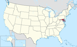
 Locatie van Maryland in de VS | |||
| Situering | |||
| County | Baltimore County | ||
| Type plaats | Census-designated place | ||
| Staat | Maryland | ||
| Coördinaten | 39° 16′ NB, 76° 44′ WL | ||
| Algemeen | |||
| Oppervlakte | 36,3 km² | ||
| - land | 36,3 km² | ||
| - water | 0,0 km² | ||
| Inwoners (2000) |
39.820 | ||
| Hoogte | 146 m | ||
| Overig | |||
| ZIP-code(s) | 21228 | ||
| FIPS-code | 14125 | ||
| |||
Demografie
Bij de volkstelling in 2000 werd het aantal inwoners vastgesteld op 39.820.[1]
Geografie
Volgens het United States Census Bureau beslaat de plaats een oppervlakte van 36,3 km², geheel bestaande uit land.
Plaatsen in de nabije omgeving
De onderstaande figuur toont nabijgelegen plaatsen in een straal van 8 km rond Catonsville.
Externe link
Wikiwand in your browser!
Seamless Wikipedia browsing. On steroids.
Every time you click a link to Wikipedia, Wiktionary or Wikiquote in your browser's search results, it will show the modern Wikiwand interface.
Wikiwand extension is a five stars, simple, with minimum permission required to keep your browsing private, safe and transparent.

