
Grayshott
plaats in Hampshire / Uit Wikipedia, de vrije encyclopedia
Grayshott is een civil parish in het bestuurlijke gebied East Hampshire, in het Engelse graafschap Hampshire.
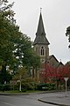 Kerk van St. Lucas
 Village Hall


Snelle feiten Situering, Regio ...
| Civil parish in Engeland | |||
|---|---|---|---|
 | |||
| Situering | |||
| Regio | South East England | ||
| Graafschap | Hampshire | ||
| District | East Hampshire | ||
| Coördinaten | 51° 7' NB, 0° 45' WL | ||
| Algemeen | |||
| Oppervlakte | 3,6988 km² | ||
| Inwoners (2011) |
2413 (654 inw./km²) | ||
| Overig | |||
| Grid code | SU872353 | ||
| ONS-code | E04004505 | ||
| Foto's | |||
 | |||
| De basisschool. | |||
| |||
Sluiten