File:München_-_Stadtbezirke_(Karte).png
Uit Wikipedia, de vrije encyclopedia
Oorspronkelijk bestand (2.119 × 1.641 pixels, bestandsgrootte: 338 kB, MIME-type: image/png)
Onderstaande beschrijving komt van de beschrijving van het bestand daar.
Articles about the boroughs of Munich in the German Wikipedia (original list)
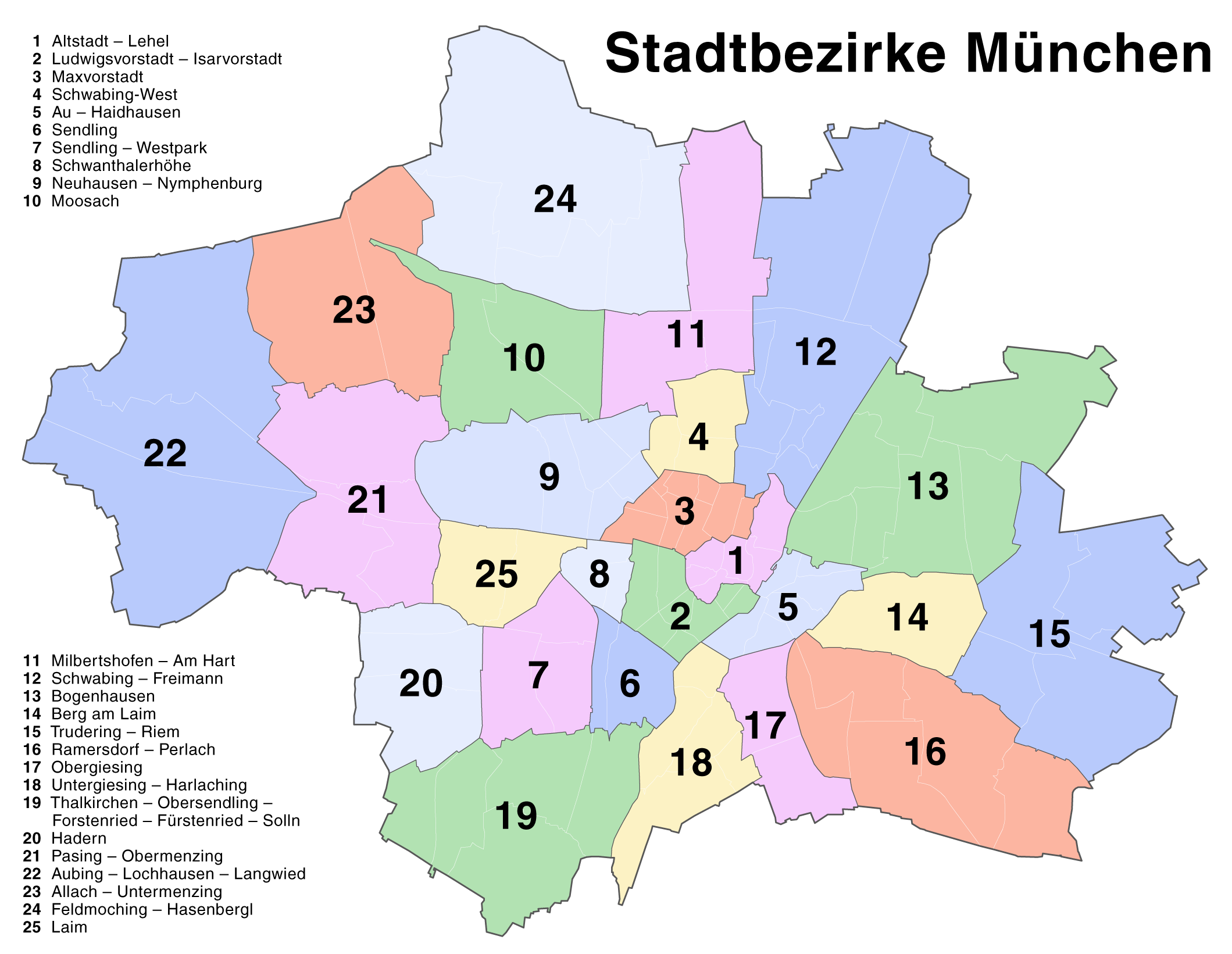
23 Allach-Untermenzing - 1 Altstadt-Lehel - 22 Aubing-Lochhausen-Langwied - 5 Au-Haidhausen - 14 Berg am Laim - 13 Bogenhausen - 24 Feldmoching-Hasenbergl - 20 Hadern - 25 Laim - 2 Ludwigsvorstadt-Isarvorstadt - 3 Maxvorstadt - 11 Milbertshofen-Am Hart - 10 Moosach - 9 Neuhausen-Nymphenburg - 17 Obergiesing - 21 Pasing-Obermenzing - 16 Ramersdorf-Perlach - 12 Schwabing-Freimann - 4 Schwabing-West - 8 Schwanthalerhöhe - 6 Sendling - 7 Sendling-Westpark - 19 Thalkirchen-Obersendling-Forstenried-Fürstenried-Solln - 15 Trudering-Riem - 18 Untergiesing-Harlaching
| BeschrijvingMünchen - Stadtbezirke (Karte).png |
Deutsch: Kartenserie der Münchner Stadtbezirke
English: Boroughs of Munich map series |
||
| Datum | |||
| Bron | Self made, created with Adobe Illustrator 12.0 | ||
| Auteur | Maximilian Dörrbecker (Chumwa) | ||
| Toestemming (Hergebruik van dit bestand) |
This map was created by Maximilian Dörrbecker. Attribution to Wikipedia or another project of the Wikimedia foundation is required if it is used outside of projects of the Wikimedia foundation. Dit bestand is gelicenseerd onder de Creative Commons-licentie Naamsvermelding-Gelijk delen 2.5 Unported
"I want to use the image. How do I do that?" You can use this map freely for any purpose, including commercial use, provided that you license it under the above license. My suggestion is to use the following text:
|
||
| Andere versies |
Die Serie besteht aus den folgenden Karten / The series consists of the following maps : Region München:
Stadt München:
|


.png)


.png)
.png)


_-_Altstadt_-_Lehel.png)
_-_Ludwigsvorstadt_-_Isarvorstadt.png)
_-_Maxvorstadt.png)
_-_Schwabing-West.png)
_-_Au_-_Haidhausen.png)
_-_Sendling.png)
_-_Sendling_-_Westpark.png)
_-_Schwanthalerh%C3%B6he.png)
_-_Neuhausen_-_Nymphenburg.png)
_-_Moosach.png)
_-_Milbertshofen_-_Am_Hart.png)
_-_Bogenhausen.png)
_-_Berg_am_Laim.png)
_-_Trudering_-_Riem.png)
_-_Ramersdorf_-_Perlach.png)
_-_Obergiesing.png)
_-_Thalkirchen_-_Obersendling_-_Forstenried_-_F%C3%BCrstenried_-_Solln.png)
_-_Hadern.png)
_-_Pasing_-_Obermenzing.png)
_-_Aubing_-_Lochhausen_-_Langwied.png)
_-_Allach_-_Untermenzing.png)
_-_Feldmoching_-_Hasenbergl.png)
_-_Laim.png)
Bijschriften
Items getoond in dit bestand
beeldt af
augustus 2007
Bestandsgeschiedenis
Klik op een datum/tijd om het bestand te zien zoals het destijds was.
| Datum/tijd | Miniatuur | Afmetingen | Gebruiker | Opmerking | |
|---|---|---|---|---|---|
| huidige versie | 20 aug 2007 18:22 | | 2.119 × 1.641 (338 kB) | Chumwa | Correction of the district numbering in the named list (many thanks to Andreas for the error hint!) |
| 18 aug 2007 18:16 |  | 2.119 × 1.641 (342 kB) | Chumwa | {{Information |Description= *{{ de }} Kartenserie der Münchner Stadtbezirke *{{ en }} Boroughs of Munich map series |Source=Self made, created with Adobe Illustrator 12.0 |Date=August 2007 |Author=Maximilian Dörrbecker ([[:de:User:Ch |
Bestandsgebruik
Geen enkele pagina gebruikt dit bestand.
Globaal bestandsgebruik
De volgende andere wiki's gebruiken dit bestand:
- Gebruikt op ba.wikipedia.org
- Gebruikt op bxr.wikipedia.org
- Gebruikt op de.wikipedia.org
- Gebruikt op en.wikipedia.org
- Gebruikt op fr.wikipedia.org
- Gebruikt op kk.wikipedia.org
- Gebruikt op lez.wikipedia.org
- Gebruikt op pl.wikivoyage.org
- Gebruikt op ru.wikipedia.org
- Gebruikt op vep.wikipedia.org
.png)