Bestand:PNW-straits.jpg
Uit Wikipedia, de vrije encyclopedia
PNW-straits.jpg (336 × 396 pixels, bestandsgrootte: 128 kB, MIME-type: image/jpeg)
| Dit is een bestand van Wikimedia Commons. Onderstaande beschrijving komt van de beschrijving van het bestand daar. |
Deze afbeelding (of alle afbeeldingen in deze categorie of pagina) is erg klein, niet corrigeerbaar te licht/donker, of toont onvoldoende het onderwerp van de foto. Als er afbeelding van een hogere beeldkwaliteit beschikbaar is kunt u overwegen deze te vervangen, anders zou er een vervanging onder een vrije licentie gevonden moeten worden of gemaakt moeten worden.
Zie alstublieft Category:Image cleanup templates voor sjablonen om afbeeldingen te markeren die alleen een clean-up nodig hebben. Voor meer hulp, zie Commons:Media for cleanup#Low quality pictures. Deutsch ∙ català ∙ English ∙ čeština ∙ español ∙ sicilianu ∙ Tiếng Việt ∙ ಕನ್ನಡ ∙ 日本語 ∙ polski ∙ മലയാളം ∙ galego ∙ македонски ∙ 中文(简体) ∙ 中文(繁體) ∙ العربية ∙ русский ∙ 中文 ∙ suomi ∙ 中文(臺灣) ∙ norsk ∙ Nederlands ∙ Plattdüütsch ∙ svenska ∙ français ∙ magyar ∙ 한국어 ∙ italiano ∙ português ∙ беларуская (тарашкевіца) ∙ +/− |
Beschrijving
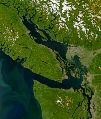
| BeschrijvingPNW-straits.jpg | Satellite image of the Strait of Georgia, Strait of Juan de Fuca, and surrounding region. The image was acquired by the Sea-viewing Wide Field-of-view Sensor (SeaWiFS) on August 9, 2001. Original image cropped to highlight the Strait of Georgia. |
| Datum | |
| Bron | NASAEarth Observatory, http://earthobservatory.nasa.gov/Newsroom/NewImages/images.php3?img_id=5051 |
| Auteur | The SeaWiFS Project, NASA/Goddard Space Flight Center, and ORBIMAGE |
Licentie
| Public domainPublic domainfalsefalse |
| This image is from the Sea-viewing Wide Field-of-view Sensor (SeaWiFS) Project and more than 5 years old.
Satellite data captured by the SeaWIFS sensor are released into the public domain 5 years after capture. Data less than five years old can be re-used only for educational or scientific purposes; any commercial use of such images must be coordinated with GeoEye. [1] |
| Public domainPublic domainfalsefalse |
| This work has been released into the public domain by its copyright holder, GeoEye. This applies worldwide. In sommige landen is dit wettelijk niet mogelijk; in die gevallen geldt: GeoEye staat iedereen toe dit werk voor eender welk doel te gebruiken, zonder enige voorwaarden, tenzij zulke voorwaarden door de wet worden voorgeschreven. Public domainPublic domainfalsefalse |
Bijschriften
Items getoond in dit bestand
beeldt af
9 aug 2001
Bestandsgeschiedenis
Klik op een datum/tijd om het bestand te zien zoals het destijds was.
| Datum/tijd | Miniatuur | Afmetingen | Gebruiker | Opmerking | |
|---|---|---|---|---|---|
| huidige versie | 22 apr 2008 08:55 | | 336 × 396 (128 kB) | Pfly | {{Information |Description=Satellite image of the Strait of Georgia, Strait of Juan de Fuca, and surrounding region. The image was acquired by the Sea-viewing Wide Field-of-view Sensor (SeaWiFS) on |
Bestandsgebruik
Dit bestand wordt op de volgende pagina gebruikt:
Globaal bestandsgebruik
De volgende andere wiki's gebruiken dit bestand:
- Gebruikt op ar.wikipedia.org
- Gebruikt op ast.wikipedia.org
- Gebruikt op az.wikipedia.org
- Gebruikt op br.wikipedia.org
- Gebruikt op ca.wikipedia.org
- Gebruikt op cv.wikipedia.org
- Gebruikt op de.wikipedia.org
- Gebruikt op en.wikipedia.org
- Gebruikt op eo.wikipedia.org
- Gebruikt op es.wikipedia.org
- Gebruikt op fa.wikipedia.org
- Gebruikt op fi.wikipedia.org
- Gebruikt op fr.wikipedia.org
- Gebruikt op fr.wiktionary.org
- Gebruikt op fy.wikipedia.org
- Gebruikt op he.wikipedia.org
- Gebruikt op id.wikipedia.org
- Gebruikt op is.wikipedia.org
- Gebruikt op it.wikipedia.org
- Gebruikt op ja.wikipedia.org
- Gebruikt op ko.wikipedia.org
- Gebruikt op lv.wikipedia.org
- Gebruikt op mhr.wikipedia.org
- Gebruikt op mk.wikipedia.org
- Gebruikt op ms.wikipedia.org
- Gebruikt op no.wikipedia.org
- Gebruikt op pl.wikipedia.org
- Gebruikt op pt.wikipedia.org
- Gebruikt op ru.wikipedia.org
- Gebruikt op sh.wikipedia.org
- Gebruikt op tr.wikipedia.org
- Gebruikt op uk.wikipedia.org
- Gebruikt op ur.wikipedia.org
- Gebruikt op vi.wikipedia.org
- Gebruikt op zh.wikipedia.org
Metadata
Dit bestand bevat metadata met EXIF-informatie, die door een fotocamera, scanner of fotobewerkingsprogramma toegevoegd kan zijn.
| Gebruikte software | Adobe Photoshop CS2 Macintosh |
|---|---|
| Oriëntatie | Normaal |
| Horizontale resolutie | 72 dpi |
| Verticale resolutie | 72 dpi |
| Tijdstip laatste bestandswijziging | 21 apr 2008 23:42 |
| Kleurruimte | sRGB |