Bestand:AMH-6670-NA_Map_of_the_island_of_Formosa.jpg
Uit Wikipedia, de vrije encyclopedia
Oorspronkelijk bestand (2.400 × 1.662 pixels, bestandsgrootte: 691 kB, MIME-type: image/jpeg)
Onderstaande beschrijving komt van de beschrijving van het bestand daar.
Beschrijving
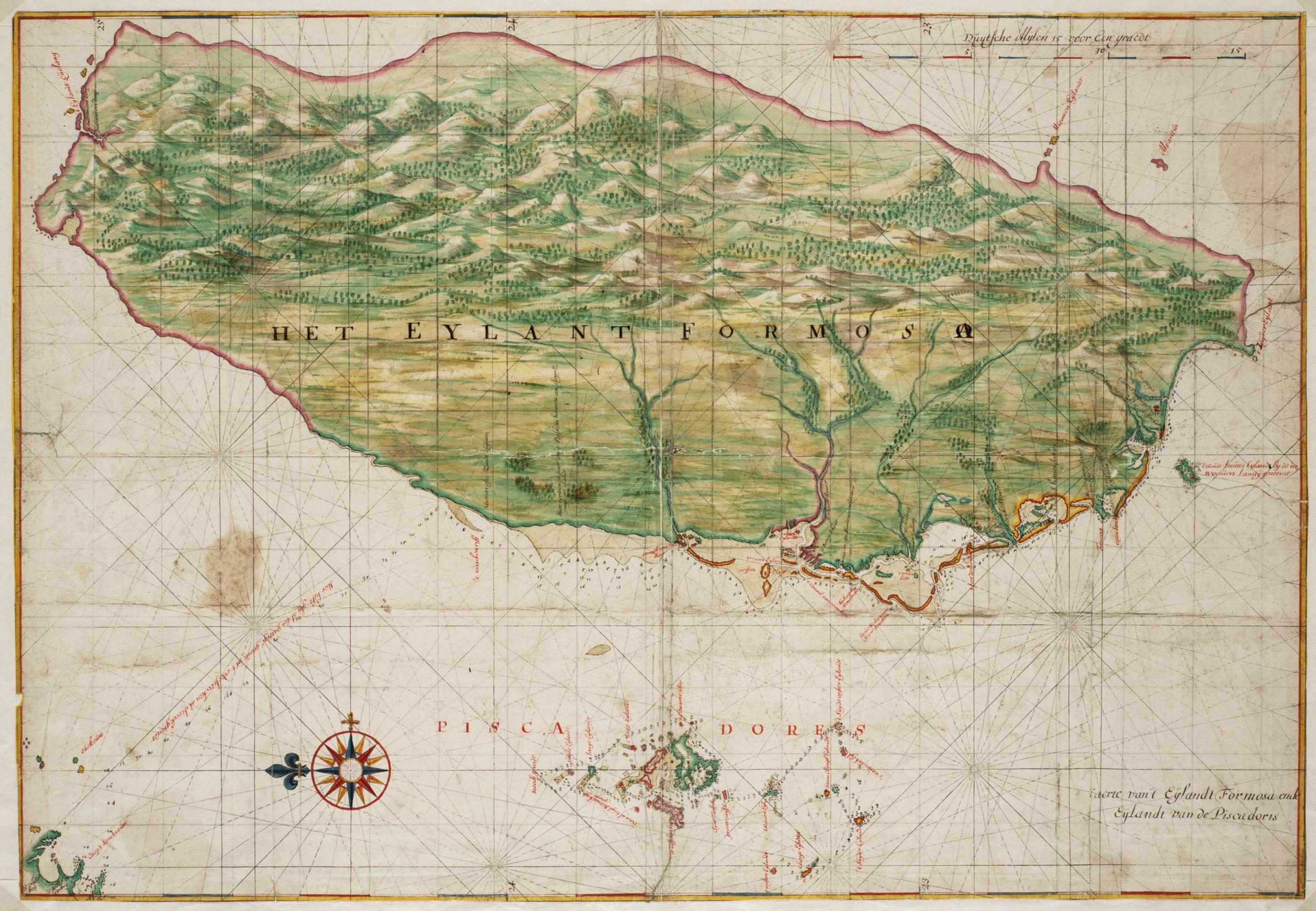
Nederlands: Kaart van het eiland Formosa
English: Map of the island of Formosa( |
||||||||||||||||||||||||
|---|---|---|---|---|---|---|---|---|---|---|---|---|---|---|---|---|---|---|---|---|---|---|---|---|
| Auteur |
creator QS:P170,Q2232496
Nederlands: Johannes Vingboons (landmeter / kaartenmaker)
English: Johannes Vingboons (land surveyor / mapmaker) |
|||||||||||||||||||||||
| Titel |
Nederlands: Kaart van het eiland Formosa
English: Map of the island of Formosa |
|||||||||||||||||||||||
| Beschrijving |
Nederlands: Titel catalogus Leupe (Nationaal Archief): Kaart van de kusten van Formosa en de Pescadores.
Lodingen aangegeven op de kaart. Op de achterzijde zijn strookjes papier geplakt met daarop letters en woorden geschreven die echter geen samenhangende tekst vormen. De contouren van Formosa en de Pescadores zijn op deze kaart exact dezelfde als die in de Atlas Blaeu-Van der Hem uit de Österreichische Nationalbibiothek , Wenen, inv. nr. Van der Hem 41:02.English: Title in the Leupe catalogue (National Archives): Kaart van de kusten van Formosa en de Pescadores.
Soundings indicated on the chart. Strips of paper have been pasted on the reverse. The strips bear letters and words, but these do not combine into a coherent text. The outlines of The island Formosa and the Pescadores on this map are exactly the same as the ones on the map in the Atlas Blaeu-Van der Hem from the Österreichische Nationalbibiothek , Vienna, inv. nr. Van der Hem 41:02. |
|||||||||||||||||||||||
| Datum |
ca. 1665 date QS:P571,+1665-00-00T00:00:00Z/9,P1480,Q5727902 |
|||||||||||||||||||||||
| Techniek |
Nederlands: aquarel/waterverf op papier
English: watercolour on paper |
|||||||||||||||||||||||
| Afmetingen |
hoogte: 68 cm; breedte: 47 cm dimensions QS:P2048,68U174728 dimensions QS:P2049,47U174728 |
|||||||||||||||||||||||
| Collectie |
institution QS:P195,Q1857081 |
|||||||||||||||||||||||
| Inventarisnummer |
NL-HaNA_4.VELH_619.52 (old number: VELH0619.52) |
|||||||||||||||||||||||
| Inscripties |
Het Eylant Formosa
|
|||||||||||||||||||||||
| Opmerkingen |
English: Subjects: chart / map / plan, compass / dial
Nederlands: Onderwerpen: plattegrond / kaart, kompas / windroos
English: Post: this image is related to a VOC trading post called Chi-lung |
|||||||||||||||||||||||
| Bron/fotograaf |
|
|||||||||||||||||||||||
| Toestemming (Hergebruik van dit bestand) |
|
|||||||||||||||||||||||
| Andere versies |
|
|||||||||||||||||||||||


| Objectlocatie | 25° 07′ 49,88″ NB, 121° 44′ 24,32″ OL | Deze en andere afbeeldingen in: OpenStreetMap |
|---|
Bijschriften
Items getoond in dit bestand
beeldt af
25°7'49.876"N, 121°44'24.317"E
image/jpeg
c8781c293cb6352865dda8e0a644f4312754e06d
707.779 byte
1.662 pixel
2.400 pixel
Bestandsgeschiedenis
Klik op een datum/tijd om het bestand te zien zoals het destijds was.
| Datum/tijd | Miniatuur | Afmetingen | Gebruiker | Opmerking | |
|---|---|---|---|---|---|
| huidige versie | 11 jun 2014 11:39 | | 2.400 × 1.662 (691 kB) | HuskyBot | == {{int:filedesc}} == {{Artwork |title = {{nl|1=Kaart van het eiland Formosa}} {{en|1=Map of the island of Formosa}} |description = {{nl|1=Titel catalogus Leupe (Nationaal Archief): ''Kaart van de kusten van F... |
Bestandsgebruik
Dit bestand wordt op de volgende 3 pagina's gebruikt:
Globaal bestandsgebruik
De volgende andere wiki's gebruiken dit bestand:
- Gebruikt op ast.wikipedia.org
- Gebruikt op en.wikipedia.org
- Gebruikt op es.wikipedia.org
- Gebruikt op fy.wikipedia.org
- Gebruikt op tr.wikipedia.org
- Gebruikt op zh.wikipedia.org