File:Ambulante_Kinderhospizdienste_in_Deutschland.PNG
From Wikipedia, the free encyclopedia
No higher resolution available.
Ambulante_Kinderhospizdienste_in_Deutschland.PNG (३७२ × ४४४ pixels, file size: ४४ KB, MIME type: image/png)
This file is from Wikimedia Commons and may be used by other projects. The description on its file description page there is shown below.

|
This health map image could be re-created using vector graphics as an SVG file. This has several advantages; see Commons:Media for cleanup for more information. If an SVG form of this image is available, please upload it and afterwards replace this template with
{{vector version available|new image name}}.
It is recommended to name the SVG file “Ambulante Kinderhospizdienste in Deutschland.svg”—then the template Vector version available (or Vva) does not need the new image name parameter. |
Summary
| DescriptionAmbulante Kinderhospizdienste in Deutschland.PNG |
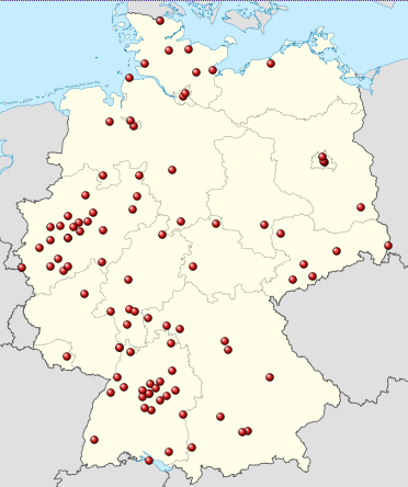
Deutsch: Positionskarte von Deutschland, eingetragen sind die Standorte ambulanter kinderhospizdienste nach DHKV ([1], Stand: März 2012 Quadratische Plattkarte, N-S-Streckung 150 %. Geographische Begrenzung der Karte: * N: 55.1° N * S: 47.2° N * W: 5.5° O * O: 15.5° O English: Location map of Germany Equirectangular projection, N/S stretching 150 %. Geographic limits of the map: * N: 55.1° N * S: 47.2° N * W: 5.5° E * E: 15.5° E Français : Carte de l'Allemagne |
| Date | (UTC) |
| Source |
This file was derived from: Germany location map.svg:  |
| Author |
|
| This is a retouched picture, which means that it has been digitally altered from its original version. Modifications: Ambulante Kinderhospizdienste eingetragen. The original can be viewed here: Germany location map.svg:
|
Licensing
I, the copyright holder of this work, hereby publish it under the following licenses:
This file is licensed under the Creative Commons Attribution-Share Alike 3.0 Unported license.
- You are free:
- to share – to copy, distribute and transmit the work
- to remix – to adapt the work
- Under the following conditions:
- attribution – You must give appropriate credit, provide a link to the license, and indicate if changes were made. You may do so in any reasonable manner, but not in any way that suggests the licensor endorses you or your use.
- share alike – If you remix, transform, or build upon the material, you must distribute your contributions under the same or compatible license as the original.

|
Permission is granted to copy, distribute and/or modify this document under the terms of the GNU Free Documentation License, Version 1.2 or any later version published by the Free Software Foundation; with no Invariant Sections, no Front-Cover Texts, and no Back-Cover Texts. A copy of the license is included in the section entitled GNU Free Documentation License.http://www.gnu.org/copyleft/fdl.htmlGFDLGNU Free Documentation Licensetruetrue |
You may select the license of your choice.
Original upload log
This image is a derivative work of the following images:
- File:Germany_location_map.svg licensed with Cc-by-sa-3.0, GFDL
- 2010-01-19T10:03:29Z NordNordWest 1073x1272 (502104 Bytes) update
- 2009-07-22T08:33:33Z NordNordWest 1075x1273 (623082 Bytes) c
- 2008-10-13T14:36:44Z NordNordWest 1075x1273 (620685 Bytes)
- 2008-10-09T21:13:47Z NordNordWest 1075x1273 (627868 Bytes) smaller file, data optimized
- 2008-06-30T20:25:05Z NordNordWest 1076x1274 (899543 Bytes) {{Information |Description= {{de|Positionskarte von [[:de:Deutschland|Deutschland]]}} Quadratische Plattkarte, N-S-Streckung 150 %. Geographische Begrenzung der Karte: * N: 55.1° N * S: 47.2° N * W: 5.5° O * O: 15.5° O {{
Uploaded with derivativeFX
Captions
Add a one-line explanation of what this file represents
Items portrayed in this file
depicts English
copyright status English
copyrighted English
inception English
१९ मार्च 2012
media type English
image/png
checksum English
c681fda2c24da74787cdbf1ad13cb6144ff91e18
data size English
४४,९९७ byte
height English
४४४ pixel
width English
३७२ pixel
File history
Click on a date/time to view the file as it appeared at that time.
| Date/Time | Thumbnail | Dimensions | छ्य्लामि | Comment | |
|---|---|---|---|---|---|
| current | २२:१९, १९ मार्च २०१२ | | ३७२ × ४४४ (४४ KB) | Gripweed | == {{int:filedesc}} == {{Information |Description={{de|Positionskarte von Deutschland}} Quadratische Plattkarte, N-S-Streckung 150 %. Geographische Begrenzung der Karte: * N: 55.1° N * S: 47.2° N * ... |
File usage
There are no pages that use this file.
Global file usage
The following other wikis use this file:
- Usage on de.wikipedia.org