ဖိုင်:Irrawaddyrivermap.jpg
From Wikipedia, the free encyclopedia
ဤနမူနာ၏ အရွယ်အစား - ၄၂၁ × ၅၉၉ ပစ်ဇယ်။ အခြား ပုံရိပ်ပြတ်သားမှု: ၁၆၈ × ၂၄၀ ပစ်ဇယ် | ၃၃၇ × ၄၈၀ ပစ်ဇယ် | ၈၆၂ × ၁၂၂၇ ပစ်ဇယ်။
မူရင်းဖိုင် (၈၆၂ × ၁၂၂၇ pixels, ဖိုင်အရွယ်အစား - ၂၀၈ KB, MIME အမျိုးအစား image/jpeg)
| ဤဖိုင်သည် Wikimedia Commons မှဖြစ်ပြီး အခြားပရောဂျက်များတွင် သုံးကောင်းသုံးလိမ့်မည်။ ယင်း၏ ဖိုင်အကြောင်းစာမျက်နှာ တွင် ဖော်ပြထားချက်ကို အောက်တွင် ပြထားသည်။ Commons သည် မူပိုင်ခွင့်လွတ်လပ်သော မီဒီယာဖိုင်များ သိုလှောင်ထားရာ နေရာ ဖြစ်သည်။ သင်လည်း ပါဝင်ကူညီနိုင်ပါသည်။ |
အကျဉ်းချုပ်
| ဖော်ပြချက်Irrawaddyrivermap.jpg |
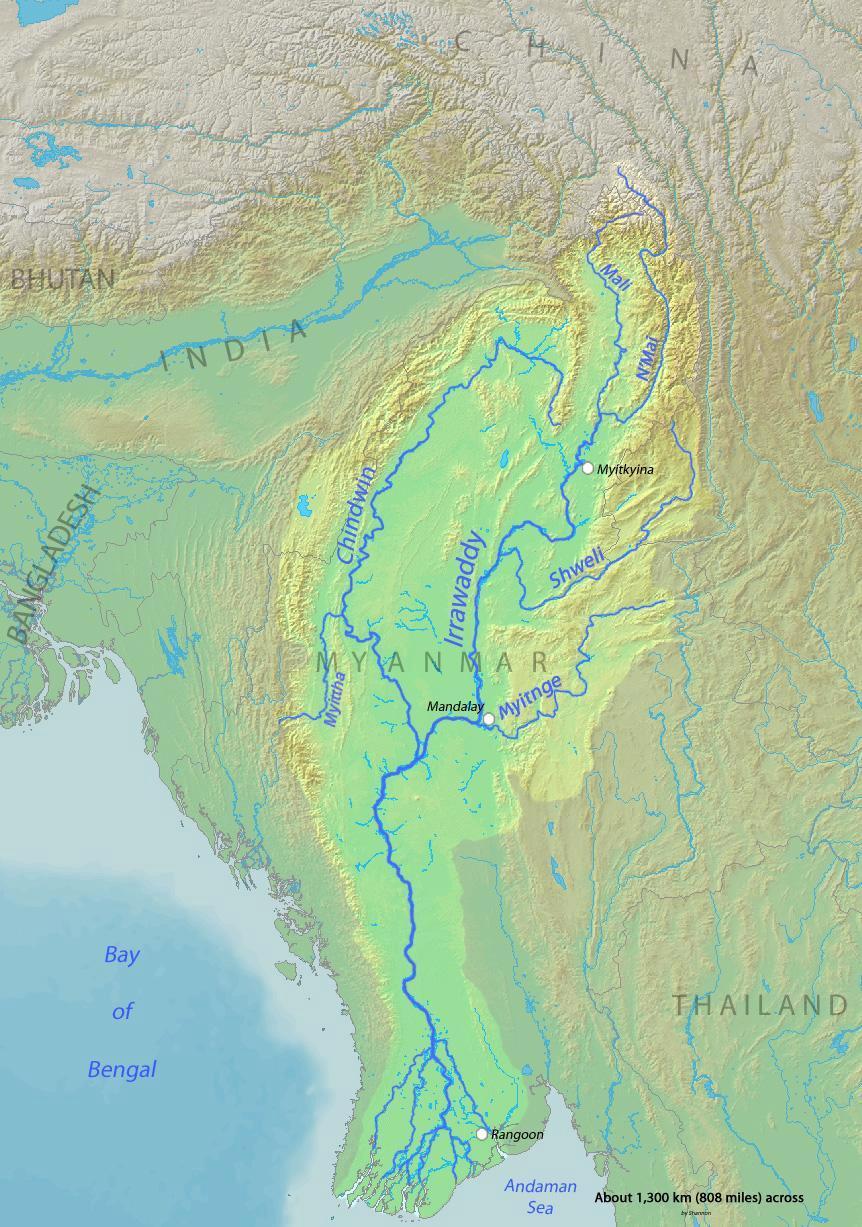
English: Map of the Irrawaddy River, which drains parts of Myanmar (Burma), Thailand and India into the Andaman Sea Français : Carte de l'Irrawaddy. Myitnge |
| ရက်စွဲ | |
| ရင်းမြစ် | Background and river course data from http://www2.demis.nl/mapserver/mapper.asp |
| စာရေးသူ | Shannon |
လိုင်စင်သတ်မှတ်ခြင်း
ကျွန်ုပ်၊ ဤလုပ်ဆောင်ချက်၏ မူပိုင်ခွင့်ပိုင်ရှင်အနေဖြင့် ဤနေရာမှ အောက်ပါလိုင်စင်များအောက်တွင် ထုတ်လွှင့်ပါသည်:

|
ဤစာတမ်းကို GNU Free Documentation License, ဗားရှင်း ၁.၂ သို့မဟုတ် Free Software Foundation မှ ဖြန့်ချီထားသော မည်သည့်ယခင်ဗားရှင်းတစ်ခုခုအောက်တွင် Invariant Sections, Front-Cover Texts နှင့် Back-Cover Texts များမပါဝင်ဘဲ ကူးယူခြင်း၊ ဖြန့်ချီခြင်း နှင့်/သို့မဟုတ် ပြင်ဆင်ပြောင်းလဲနိုင်ရန် ခွင့်ပြုသည်။ လိုင်စင်မူပွားကို GNU Free Documentation License ခေါင်းစဉ်အောက်တွင် ထည့်သွင်းထားသည်။http://www.gnu.org/copyleft/fdl.htmlGFDLGNU Free Documentation Licensetruetrue |
This file is licensed under the Creative Commons Attribution-Share Alike Attribution-Share Alike 4.0 International, 3.0 Unported, 2.5 Generic, 2.0 Generic and 1.0 Generic license.
- သင်သည် လွတ်လပ်စွာ:
- မျှဝေရန် – ဖန်တီးမှုကို ကူးယူရန်၊ ဖြန့်ဖြူးရန်နှင့် ထုတ်လွှင့်ရန်
- ပြန်ရောနှောရန် – ဖန်တီးမှုကို ပြင်ဆင်ညှိနှိုင်းရန်
- အောက်ပါ အခြေအနေများတွင်:
- မှတ်ယူနိုင်ခြင်း – ပြောင်းလဲမှုများ ပြုလုပ်ခဲ့ပါက ဖန်တီးသူ သို့မဟုတ် လိုင်စင်ရှိသူမှ သတ်မှတ်သော အမျိုးအစားကို လိုက်နာရမည် (ဆိုလိုသည်မှာ သင့်အား သို့မဟုတ် သင့်ဖန်တီးမှုတွင် အသုံးပြုခြင်းအား ထောက်ခံချက်ပေးသည်ဟု မဆိုလိုပါ)။
- ထပ်တူမျှဝေ – ဤဖန်တီးမှုအား ပြင်ဆင်ခြင်း၊ ပြောင်းလဲခြင်း သို့မဟုတ် ထပ်ဆင့် ဖန်တီးခြင်း ပြုလုပ်ပါက ရရှိလာသော ဖန်တီးမှုကို ဤဖန်တီးမှုနှင့် သို့မဟုတ် ဆင်တူသော လိုင်စင်ဖြင့်သာ ဖြန့်ချိသင့်သည်။
သင်အလိုရှိရာ လိုင်စင်ကို ရွေးချယ်နိုင်ပါသည်။
ပုံစာများ
ဤဖိုင်၏ဆိုလိုရင်းကို စာတစ်ကြောင်းရှင်းလင်းချက်ဖြင့် ထည့်သွင်းရန်
Items portrayed in this file
depicts အင်္ဂလိပ်
some value
copyrighted အင်္ဂလိပ်
၂ မတ် 2010
ဖိုင်မှတ်တမ်း
ဖိုင်ကို ယင်းနေ့စွဲ အတိုင်း မြင်နိုင်ရန် နေ့စွဲ/အချိန် တစ်ခုခုပေါ်တွင် ကလစ်နှိပ်ပါ။
| နေ့စွဲ/အချိန် | နမူနာပုံငယ် | မှတ်တမ်း ဒိုင်မန်းရှင်းများ | အသုံးပြုသူ | မှတ်ချက် | |
|---|---|---|---|---|---|
| ကာလပေါ် | ၀၀:၃၂၊ ၁ ဒီဇင်ဘာ ၂၀၁၅ | | ၈၆၂ × ၁၂၂၇ (၂၀၈ KB) | Xufanc | Myittha River |
| ၀၈:၃၀၊ ၃၀ နိုဝင်ဘာ ၂၀၁၅ |  | ၈၆၂ × ၁၂၂၇ (၂၀၈ KB) | Xufanc | Reverted to version as of 08:22, 30 November 2015 (UTC) | |
| ၀၈:၂၈၊ ၃၀ နိုဝင်ဘာ ၂၀၁၅ |  | ၈၆၂ × ၁၂၂၇ (၂၀၈ KB) | Xufanc | Reverted to version as of 08:18, 30 November 2015 (UTC) | |
| ၀၈:၂၅၊ ၃၀ နိုဝင်ဘာ ၂၀၁၅ |  | ၈၆၂ × ၁၂၂၇ (၂၀၈ KB) | Xufanc | Reverted to version as of 08:18, 30 November 2015 (UTC) | |
| ၀၈:၂၂၊ ၃၀ နိုဝင်ဘာ ၂၀၁၅ |  | ၈၆၂ × ၁၂၂၇ (၂၀၈ KB) | Xufanc | added name of tributary | |
| ၀၈:၁၈၊ ၃၀ နိုဝင်ဘာ ၂၀၁၅ |  | ၈၆၂ × ၁၂၂၇ (၂၀၈ KB) | Xufanc | added name of tributary | |
| ၀၆:၃၈၊ ၂၄ စက်တင်ဘာ ၂၀၁၄ |  | ၈၆၂ × ၁၂၂၇ (၂၁၉ KB) | Xufanc | Corrected wrong label | |
| ၀၄:၀၆၊ ၃ မတ် ၂၀၁၀ |  | ၈၆၂ × ၁၂၂၇ (၆၅၃ KB) | Shannon1 | {{Information |Description={{en|1=Map of the Irrawaddy River, which drains parts of Myanmar (Burma), Thailand and India into the Andaman Sea}} |Source=Background and river course data from http://www2.demis.nl/mapserver/mapper.asp |Author=[[User:Shannonc |
ဖိုင်သုံးစွဲမှု
အောက်ပါ 6 စာမျက်နှာများ သည် ဤဖိုင်ကို အသုံးပြုထားသည်:
ဂလိုဘယ် ဖိုင်သုံးစွဲမှု
အောက်ပါ အခြားဝီကီများတွင် ဤဖိုင်ကို အသုံးပြုထားသည်-
- af.wikipedia.org တွင် အသုံးပြုမှု
- ar.wikipedia.org တွင် အသုံးပြုမှု
- ast.wikipedia.org တွင် အသုံးပြုမှု
- azb.wikipedia.org တွင် အသုံးပြုမှု
- be-tarask.wikipedia.org တွင် အသုံးပြုမှု
- bg.wikipedia.org တွင် အသုံးပြုမှု
- bh.wikipedia.org တွင် အသုံးပြုမှု
- blk.wikipedia.org တွင် အသုံးပြုမှု
- bn.wikipedia.org တွင် အသုံးပြုမှု
- br.wikipedia.org တွင် အသုံးပြုမှု
- ca.wikipedia.org တွင် အသုံးပြုမှု
- cs.wikipedia.org တွင် အသုံးပြုမှု
- cy.wikipedia.org တွင် အသုံးပြုမှု
- de.wikipedia.org တွင် အသုံးပြုမှု
- en.wikipedia.org တွင် အသုံးပြုမှု
- en.wikinews.org တွင် အသုံးပြုမှု
- es.wikipedia.org တွင် အသုံးပြုမှု
- eu.wikipedia.org တွင် အသုံးပြုမှု
- fa.wikipedia.org တွင် အသုံးပြုမှု
- fr.wikipedia.org တွင် အသုံးပြုမှု
- gl.wikipedia.org တွင် အသုံးပြုမှု
- hi.wikipedia.org တွင် အသုံးပြုမှု
- hr.wikipedia.org တွင် အသုံးပြုမှု
- hu.wikipedia.org တွင် အသုံးပြုမှု
- hy.wikipedia.org တွင် အသုံးပြုမှု
- id.wikipedia.org တွင် အသုံးပြုမှု
- ja.wikipedia.org တွင် အသုံးပြုမှု
- ka.wikipedia.org တွင် အသုံးပြုမှု
- ko.wikipedia.org တွင် အသုံးပြုမှု
- mk.wikipedia.org တွင် အသုံးပြုမှု
- ml.wikipedia.org တွင် အသုံးပြုမှု
- pl.wikipedia.org တွင် အသုံးပြုမှု
ဤဖိုင်ကို အခြားနေရာများတွင် အသုံးပြုထားမှုများအား ကြည့်ရှုရန်။
မီတာဒေတာ
ဤဖိုင်တွင် သတင်းအချက်အလက် အပိုများ ပါဝင်သည်။ ဒီဂျစ်တယ် ကင်မရာ သို့ စကင်နာများက ထည့်ပေါင်းပေးလိုက်ခြင်း ဖြစ်ကောင်းဖြစ်မည်။
အကယ်၍ ဖိုင်ကို မူရင်းအခြေအနေမှ ပြုပြင်လိုက်ပါက အသေးစိတ်အချို့သည် ပြုပြင်ထားသောဖိုင်တွင် အပြည့်အစုံ ပြန်ပါလာမည်မဟုတ်။
| ဒေတာဖန်တီးခဲ့သော နေ့စွဲနှင့် အချိန် | ၂၀:၀၄၊ ၂ မတ် ၂၀၁၀ |
|---|---|
| မျက်နှာပြင် အသားကျမှု | ပုံမှန် |
| အသုံးပြုထားသော ဆော့ဝဲ | Adobe Photoshop Elements 6.0 Macintosh |
| ဖိုင်အပြောင်းအလဲ ရက်စွဲနှင့် အချိန် | ၂၀:၀၄၊ ၂ မတ် ၂၀၁၀ |
| ဒီဂျစ်တယ်ပြောင်းသည့် နေ့ရက်နှင့် အချိန် | ၂၀:၀၄၊ ၂ မတ် ၂၀၁၀ |
| ရက်စွဲအချိန်မူလ စက္ကန့်ခွဲများ | 00 |
| DateTimeDigitized subseconds | 00 |
| အရောင်နေရာ | sRGB |