Stampa:Sketch_map_Samoa_in_the_Pacific.jpg
From Wikipedia, the free encyclopedia
Fajl oriġinali (843 × 648 pixel, dimensjoni: 104 KB, tip ta' MIME: image/jpeg)
| Dan huwa fajl mill-Wikimedia Commons. Il-deskrizzjoni fuq il-paġna ta' diskussjoni oriġinali tidher hawn taħt.
|

|
This map image could be re-created using vector graphics as an SVG file. This has several advantages; see Commons:Media for cleanup for more information. If an SVG form of this image is available, please upload it and afterwards replace this template with
{{vector version available|new image name}}.
It is recommended to name the SVG file “Sketch map Samoa in the Pacific.svg”—then the template Vector version available (or Vva) does not need the new image name parameter. |
 | This map image was uploaded in the JPEG format even though it consists of non-photographic data. This information could be stored more efficiently or accurately in the PNG or SVG format. If possible, please upload a PNG or SVG version of this image without compression artifacts, derived from a non-JPEG source (or with existing artifacts removed). After doing so, please tag the JPEG version with {{Superseded|NewImage.ext}} and remove this tag. This tag should not be applied to photographs or scans. If this image is a diagram or other image suitable for vectorisation, please tag this image with {{Convert to SVG}} instead of {{BadJPEG}}. If not suitable for vectorisation, use {{Convert to PNG}}. For more information, see {{BadJPEG}}. |  |
Taqsira
| DeskrizzjoniSketch map Samoa in the Pacific.jpg |
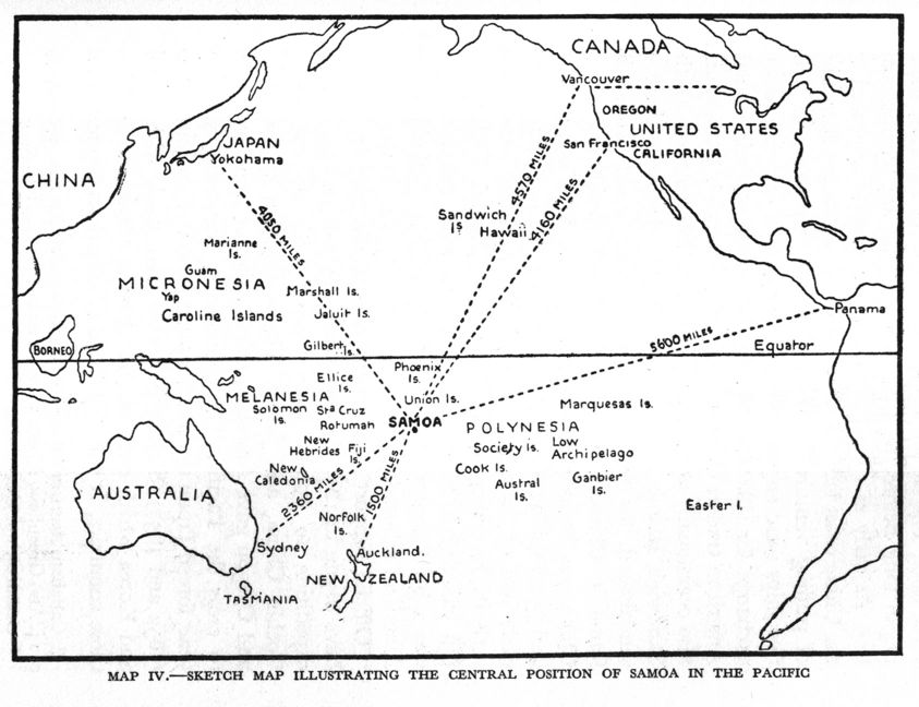
English: Sketch map illustrating the central position of Samoa in the Pacific. |
| Data | |
| Sors | Sketch from The Origins of International Rivalry in Samoa: 1845–1884 NZETC |
| Awtur | Sylvia Masterman |
Liċenzja
| Public domainPublic domainfalsefalse |
This New Zealand work is in the public domain in New Zealand, because its copyright has expired or it is not subject to copyright (details). According to the New Zealand Copyright Act of 1994 as elaborated on by the Standing Committee on Copyright of the Library and Information Association of New Zealand (LIANZA), as of May 2011:
1 Some government publications are not subject to copyright, including bills, acts, regulations, court judgments, royal commission and select committee reports, etc. See references [1] or [2] for the full list.
|
 | ||||||||||||||||||||||
Captions
Items portrayed in this file
depicts Ingliż
1934
Kronoloġija tal-fajl
Agħfas fuq il-grupp data/ħin biex tara l-fajl biex tara kif jidher dak il-ħin.
| Data/Ħin | Minjatura | Qisien | Utent | Kumment | |
|---|---|---|---|---|---|
| kurrenti | 00:01, 30 Ġunju 2010 | | 843 × 648 (104 KB) | Teinesavaii | {{Information |Description={{en|1=Sketch map illustrating the central position of Samoa in the Pacific. }} |Source=[http://www.google.co.nz/imgres?imgurl=http://www.nzetc.org/etexts/MasOrig/MasOrig107a(h280).jpg&imgrefurl=http://www.nzetc.org/tm/scholarly |
Użu tal-fajl
Il-Paġna segwenti twassal għal din l-istampa:
L-użu globali tal-fajl
Il-wikis segwenti jużaw dan il-fajl:
- Użu fuq bn.wikipedia.org
- Użu fuq de.wikipedia.org
- Użu fuq en.wikipedia.org
- Użu fuq it.wikipedia.org
- Użu fuq sk.wikipedia.org
- Użu fuq zh.wikipedia.org
Metadati
Dan il-fajl fih aktar informazzjoni, aktarx ġie miżjud minn kamera diġitali jew skanner li ġew użati sabiex joħolquh jew biex jagħmluh diġitali.
Jekk il-fajl ġie modifikat mill-istat oriġinali, xi dettalji jistgħu ma jikkorispondux mal-verżjoni kurrenti.
| Orjentazzjoni | Normali |
|---|---|
| Riżoluzzjoni orizzontali | 300 dpi |
| Riżoluzzjoni vertikali | 300 dpi |
| Software | Adobe Photoshop CS3 Windows |
| Data jew ħin ta' modifiki tal-fajl | 15:26, 17 Settembru 2008 |
| Spazju tal-kuluri | Mhux kalibrata |