File:Rongbuk_Glacier_animation.gif
From Wikipedia, the free encyclopedia
Fajl oriġinali (990 × 610 pixel, dimensjoni: 1.68 MB, tip ta' MIME: image/gif, ċiklika, 4 frejms, 3.2 s)
| Dan huwa fajl mill-Wikimedia Commons. Il-deskrizzjoni fuq il-paġna ta' diskussjoni oriġinali tidher hawn taħt.
|
Taqsira
| DeskrizzjoniRongbuk Glacier animation.gif |
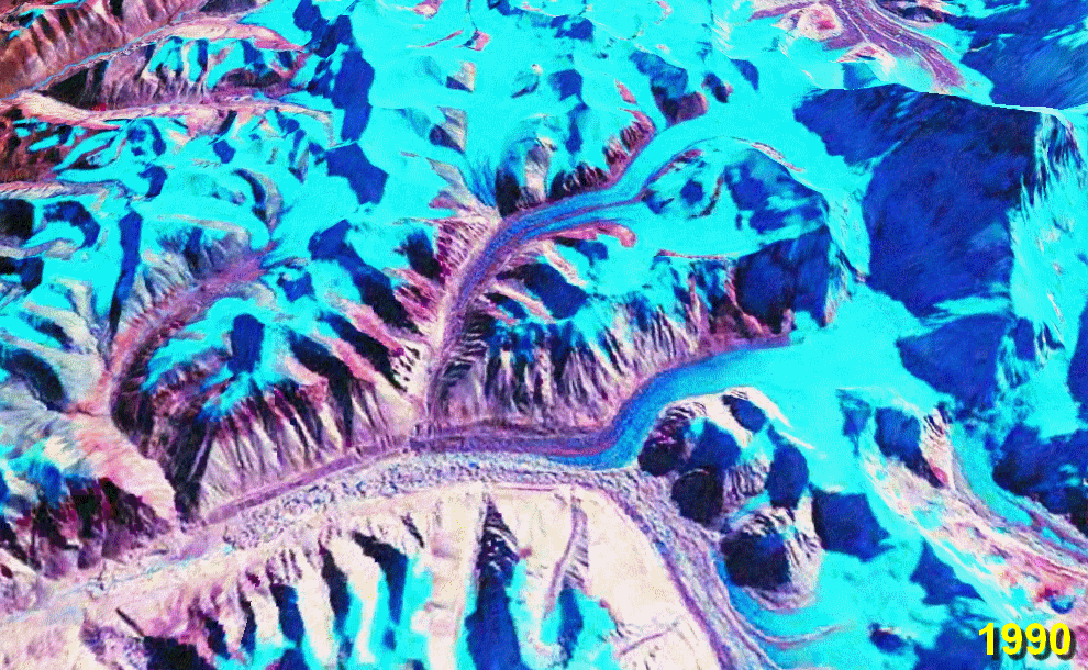
English: Rongbuk (Rongphu) Glacier, Tibet; Mount Everest at the top right.
The lower ~10 km of the glacier is moraine-covered. Its terminus (snout) is near the bottom left at the source of the Rongbuk River. There is no snout retreat over this interval, but the large increase in the area of meltwater lakes on the glacier surface suggests significant thinning. The big lake in the 2010 image is nearly 2 km long. Also note the reduction in glacier cover on the foothills to the left. Stacked NASA World Wind images from the 1990 and 2000 NASA GeoCover collections and USGS Landsat 7 imagery from October 2009[1] (all Landsat 4/5 and Landsat 7 MSS/TM/ETM+ false-colour images). Diagonal lines in the 2010 image are due to the ETM+ scan line correction failure on Landsat 7. worldwind://goto/world=Earth&lat=28.07778&lon=86.88972&alt=19166&dir=92.2&tilt=31.6 (This is an animated GIF image. If animation is not visible, it may be because Microsoft Office Picture Manager has your GIF file association. That application does not support GIF animation. Change the association to any standard picture viewer, and restart your browser.) |
| Data | 28 Settembru 2006 (original upload date) |
| Sors | Opra proprja. Made with NASA World Wind from NASA public domain imagery |
| Awtur | Glen Fergus |
Related glacier retreat images:
|


Liċenzja
Made with NASA World Wind from NASA public domain imagery

|
Huwa permess li tikkopja, tiddistribwixxi u/jew timmodifika dan id-dokument abbażi tat-termini tal-Liċenzja ta' Dokumentazzjoni Ħielsa tal-GNU, Verżjoni 1.2 jew kwalunkwe verżjoni oħra pubblikata mill-Free Software Foundation; mingħajr ebda sezzjoni non-modifikabbli, mingħajr test tal-faċċata u mingħajr test tal-qoxra. Kopja tal-liċenzja hi inkluża fis-sezzjoni intitolata Test tal-Liċenzja ta' Dokumentazzjoni Ħielsa tal-GNU".http://www.gnu.org/copyleft/fdl.htmlGFDLGNU Free Documentation Licensetruetrue |
| Dan il-fajl huwa liċenzjat taħt it-termini tal-liċenzja Creative Commons Attribuzzjoni-Aqsam bl-istess mod 3.0 Unported | ||
| ||
| This licensing tag was added to this file as part of the GFDL licensing update.http://creativecommons.org/licenses/by-sa/3.0/CC BY-SA 3.0Creative Commons Attribution-Share Alike 3.0truetrue |
Captions
Items portrayed in this file
depicts Ingliż
some value
copyright status Ingliż
copyrighted Ingliż
source of file Ingliż
28 Settembru 2006
Kronoloġija tal-fajl
Agħfas fuq il-grupp data/ħin biex tara l-fajl biex tara kif jidher dak il-ħin.
| Data/Ħin | Minjatura | Qisien | Utent | Kumment | |
|---|---|---|---|---|---|
| kurrenti | 06:11, 29 Jannar 2010 | | 990 × 610 (1.68 MB) | Glen Fergus | Version 2 - 2010 |
| 11:07, 28 Settembru 2006 |  | 992 × 654 (950 KB) | Glen Fergus | == Summary == Rongbuk Glacier, Tibet. Mount Everest at the top right. The is no snout retreat over this interval, but the large increase in the area of meltwater lakes suggests significant thinning. Stacked NASA [[w:en:World W |
Użu tal-fajl
L-ebda paġna fuq il-Wikipedija Maltija torbot lejn dan il-fajl.
L-użu globali tal-fajl
Il-wikis segwenti jużaw dan il-fajl:
- Użu fuq az.wikipedia.org
- Użu fuq cs.wikipedia.org
- Użu fuq en.wikipedia.org
- Użu fuq es.wikipedia.org
- Użu fuq it.wikipedia.org
- Użu fuq ml.wikipedia.org
- Użu fuq ru.wikipedia.org
- Użu fuq uk.wikipedia.org
- Użu fuq zh.wikipedia.org