Fail:Map_Denmark_CIA_extended.gif
From Wikipedia, the free encyclopedia
Map_Denmark_CIA_extended.gif (300 × 347 piksel, saiz fail: 16 KB, jenis MIME: image/gif)
Fail ini dari Wikimedia Commons dan mungkin digunakan oleh projek lain. Penerangan pada laman penerangan failnya di sana ditunjukkan di bawah.
Ringkasan
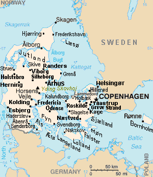
| KeteranganMap Denmark CIA extended.gif | Map of Denmark, showing largest cities and island/region names. Most city names (31) have been labeled with font-face Arial or Arial Narrow, as font-size 8 or 10; the island/region names are labeled on the diagonal at a 20-degree slant. Denmark contains over 300 towns, but they are evenly dispersed around 35 main towns, except near Copenhagen, which has very high density. |
| Tarikh | |
| Sumber | Derivative of CIA map (Wikimedia Commons): Image:Denmark-CIA WFB Map.png (adding 25 labels, restoring color to CIA hues, and magnified 15%) |
| Pengarang | Wikid77 (derivative of CIA map, adding 25 labels) |
| Versi lain |
This map has some variations:
|
Perlesenan
| Public domainPublic domainfalsefalse |
This image is in the public domain because it contains materials that originally came from the United States Central Intelligence Agency's World Factbook.
Bahasa Indonesia ∙ čeština ∙ Deutsch ∙ eesti ∙ English ∙ español ∙ Esperanto ∙ français ∙ galego ∙ hrvatski ∙ italiano ∙ Nederlands ∙ norsk nynorsk ∙ polski ∙ português ∙ sicilianu ∙ slovenščina ∙ suomi ∙ Türkçe ∙ Zazaki ∙ беларуская (тарашкевіца) ∙ македонски ∙ русский ∙ српски / srpski ∙ українська ∙ ქართული ∙ বাংলা ∙ தமிழ் ∙ മലയാളം ∙ 한국어 ∙ 日本語 ∙ 中文 ∙ 中文(简体) ∙ 中文(繁體) ∙ العربية ∙ +/− |
 |
Format

This file is purposely maintained in GIF format (most international GIF-related patents have expired) for compatibility with the original CIA maps. Semi-automatic conversions to PNG-format might lose the color hues of the CIA maps, tending to shift to lighter blue and shift beige to white. A larger, detailed version of the map is being expanded, with more of the smaller 300 towns added.
Captions
Items portrayed in this file
menggambarkan
29 Ogos 2007
Sejarah fail
Klik pada tarikh/waktu untuk melihat rupa fail tersebut pada waktu itu.
| Tarikh/Waktu | Gambar kenit | Ukuran | Pengguna | Komen | |
|---|---|---|---|---|---|
| semasa | 16:26, 30 November 2012 | | 300 × 347 (16 KB) | Ras67 | cropped |
| 13:51, 4 September 2007 |  | 300 × 350 (16 KB) | Wikid77 | relabeled "NORWAY"/"POLAND"; raised "Taastrup"/"Koge" near city-dots | |
| 15:41, 3 September 2007 |  | 300 × 350 (16 KB) | Wikid77 | added "Kalundborg" by lowering "Fredericia"/"Odense"/"Fyn" and lowered Copenhagen star, "Taastrup"/"Koge" and "Greve Strand" etc. | |
| 13:24, 31 Ogos 2007 |  | 300 × 350 (16 KB) | Wikid77 | slashed 'o' 3x | |
| 06:04, 29 Ogos 2007 |  | 300 × 350 (16 KB) | Wikid77 | {{Information | Description=Map of Denmark, showing largest cities and island/region names. | Source=Derivative of CIA map | Date=29-August-2007 | Author= Wikid77 (derivative of CIA map) | Permission=(see below) }} |
Penggunaan fail
8 buah laman berikut menggunakan fail ini:
Penggunaan fail sejagat
Fail ini digunakan oleh wiki-wiki lain yang berikut:
- Penggunaan di ast.wikipedia.org
- Penggunaan di ca.wikipedia.org
- Penggunaan di es.wikipedia.org
- Penggunaan di et.wikipedia.org
- Penggunaan di fa.wikipedia.org
- Penggunaan di gl.wikipedia.org
- Penggunaan di hr.wikipedia.org
- Penggunaan di ja.wikipedia.org
- Penggunaan di kn.wikipedia.org
- Penggunaan di ko.wikipedia.org
- Penggunaan di mk.wikipedia.org
- Penggunaan di pt.wikipedia.org
- Penggunaan di th.wikipedia.org
- Penggunaan di vi.wikipedia.org
- Penggunaan di zh.wikipedia.org