चित्र:Kara_Sea_map.png
From Wikipedia, the free encyclopedia
या झलकेचा आकार: ६५८ × ५९९ पिक्सेल पिक्सेल. इतर resolutions: २६४ × २४० पिक्सेल | ५२७ × ४८० पिक्सेल | ९४२ × ८५८ पिक्सेल.
मूळ संचिका (९४२ × ८५८ पिक्सेल, संचिकेचा आकार: २५८ कि.बा., MIME प्रकार: image/png)
ही संचिका Wikimedia Commons येथील असून ती इतर प्रकल्पात वापरलेली असू शकते. तिचे तेथील संचिका वर्णन पान खाली दाखवले आहे.

|
This locator map image could be re-created using vector graphics as an SVG file. This has several advantages; see Commons:Media for cleanup for more information. If an SVG form of this image is available, please upload it and afterwards replace this template with
{{vector version available|new image name}}.
It is recommended to name the SVG file “Kara Sea map.svg”—then the template Vector version available (or Vva) does not need the new image name parameter. |
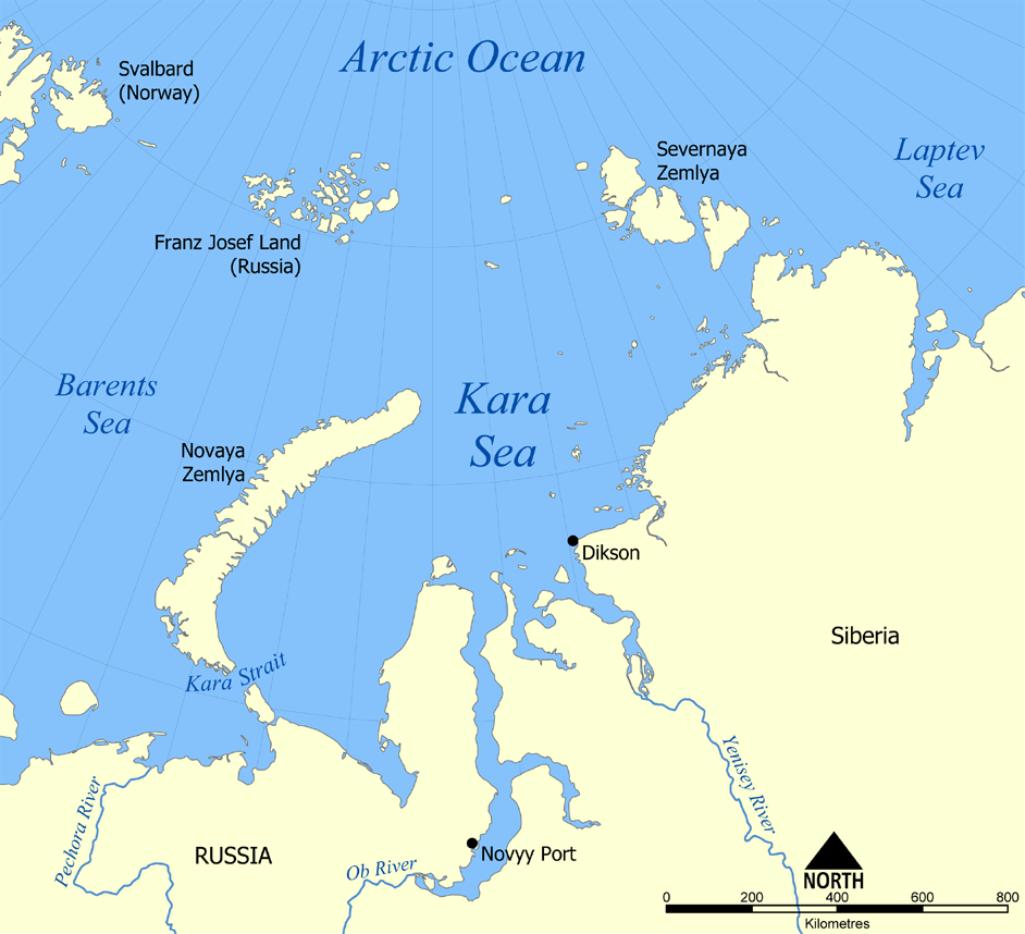
This map shows the location of the Kara Sea north of Russia. The sea is located south of the Arctic Ocean, east of the Barents Sea, west of the Laptev Sea, and is bounded by the Severnaya Zemlya and Novaya Zemlya.
Created by NormanEinstein, November 29, 2005.
मी, या कामाचा/कामाची परवानाधारक, खालील परवान्यांअंतर्गत हे काम येथे प्रकाशित करत आहे :

|
फ्री सॉफ्टवेअर फाऊंडेशन द्वारे प्रकाशित जीएनयू मुक्त दस्ताऐवजीकरण परवाना, आवृत्ती १.२ किंवा त्यानंतरची,या अंतर्गत; या दस्तावेजास, नकलविण्याची, वितरणाची व/किंवा फेरबदलाची परवानगी दिल्या जाते या अटींसह कि त्यात कोणतेही निश्चलित(Invariant) विभाग नकोत,पृष्टपान मजकूर नको व मलपान मजकूर नको. GNU Free Documentation License हा मथळा असलेल्या विभागात,या परवान्याची प्रत अंतर्भूत केलेली आहे.http://www.gnu.org/copyleft/fdl.htmlGFDLGNU Free Documentation Licensetruetrue |
| ही संचिका खालील परवान्याअंतर्गत आहे - क्रीएटिव्ह कॉमन्स Attribution-Share Alike 3.0 Unported. | ||
| ||
| GFDL चा भाग म्हणून परवाना अपडेट हि परवाना खूण या संचिकेस जोडलेली होती. (संचिका म्हणजे File)http://creativecommons.org/licenses/by-sa/3.0/CC BY-SA 3.0Creative Commons Attribution-Share Alike 3.0truetrue |
तुमच्या पसंतीचा परवाना तुम्ही निवडू शकता.
derivative works
Derivative works of this file:
Captions
Add a one-line explanation of what this file represents
Map of Kara Sea
Items portrayed in this file
depicts इंग्रजी
copyright status इंग्रजी
copyrighted इंग्रजी
संचिकेचा इतिहास
संचिकेची त्यावेळची आवृत्ती बघण्यासाठी त्या दिनांक/वेळेवर टिचकी द्या.
| दिनांक/वेळ | छोटे चित्र | आकार | सदस्य | प्रतिक्रीया | |
|---|---|---|---|---|---|
| सद्य | ०१:५६, १५ जुलै २०१२ | | ९४२ × ८५८ (२५८ कि.बा.) | Ras67 | cropped, opt. |
| ०३:४२, ३० नोव्हेंबर २००५ |  | ९५२ × ८६८ (३८२ कि.बा.) | NormanEinstein | This map shows the location of the Kara Sea north of Russia. The sea is located south of the Arctic Ocean, east of the Barents Sea, west of the Laptev Sea, and is bounded by the Severnaya Zemlya and Novaya Zemlya. Created by NormanEinstein, November 29, |
दुवे
खालील पाने या संचिकेला जोडली आहेत:
जागतिक संचिका उपयोग
संचिकाचे इतर विकिपीडियावरील वापरः
- af.wikipedia.org वरील उपयोग
- an.wikipedia.org वरील उपयोग
- ar.wikipedia.org वरील उपयोग
- avk.wikipedia.org वरील उपयोग
- azb.wikipedia.org वरील उपयोग
- az.wikipedia.org वरील उपयोग
- bcl.wikipedia.org वरील उपयोग
- be.wikipedia.org वरील उपयोग
- bg.wikipedia.org वरील उपयोग
- bn.wikipedia.org वरील उपयोग
- br.wikipedia.org वरील उपयोग
- bs.wikipedia.org वरील उपयोग
- ca.wikipedia.org वरील उपयोग
- cs.wikipedia.org वरील उपयोग
- cy.wikipedia.org वरील उपयोग
- da.wikipedia.org वरील उपयोग
- de.wikipedia.org वरील उपयोग
- en.wikipedia.org वरील उपयोग
- en.wiktionary.org वरील उपयोग
- eo.wikipedia.org वरील उपयोग
- es.wikipedia.org वरील उपयोग
- eu.wikipedia.org वरील उपयोग
- fa.wikipedia.org वरील उपयोग
- fi.wikipedia.org वरील उपयोग
- frr.wikipedia.org वरील उपयोग
- fr.wikipedia.org वरील उपयोग
या संचिकेचे अधिक वैश्विक उपयोग पहा
"https://mr.wikipedia.org/wiki/चित्र:Kara_Sea_map.png" पासून हुडकले