File:1844_Electoral_Map.png
From Wikipedia, the free encyclopedia
Эх файл (867 × 635 пиксел, файлын хэмжээ: 124 КБ, MIME төрөл: image/png)
Энэ файл нь Wikimedia Commons-нх бөгөөд бусад төслүүд үүнийг хэрэглэх боломжтой. Доор файлын тайлбарын хуудсан дээрх тайлбарыг оруулсан байгаа:
| U.S. presidential election maps from the National Atlas of the United States |
| See also: SVG maps |
| 1789 · 1792 · 1796 · 1800 · 1804 · 1808 · 1812 · 1816 · 1820 · 1824 · 1828 · 1832 · 1836 · 1840 · 1844 · 1848 · 1852 · 1856 · 1860 · 1864 · 1868 · 1872 · 1876 · 1880 · 1884 · 1888 · 1892 · 1896 · 1900 · 1904 · 1908 · 1912 · 1916 · 1920 · 1924 · 1928 · 1932 · 1936 · 1940 · 1944 · 1948 · 1952 · 1956 · 1960 · 1964 · 1968 · 1972 · 1976 · 1980 · 1984 · 1988 · 1992 · 1996 · 2000 · 2004 |
Товч агуулга
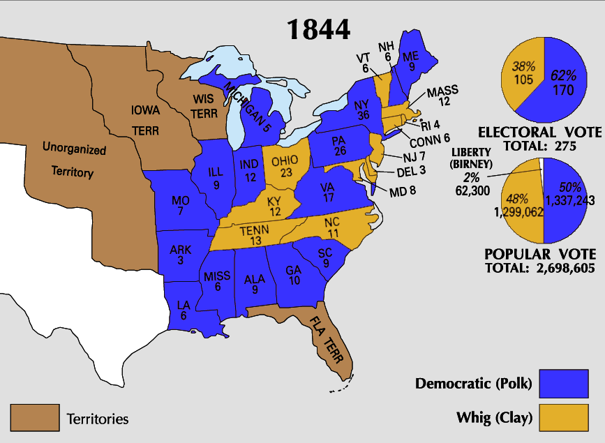
| Тайлбар1844 Electoral Map.png |
This file has no description, and may be lacking other information.
Please provide a meaningful description of this file. |
| Эх үүсвэр | https://nationalmap.gov/small_scale/printable/elections.html |
| Зохиогч | United States Geological Survey |

|
This election map image could be re-created using vector graphics as an SVG file. This has several advantages; see Commons:Media for cleanup for more information. If an SVG form of this image is available, please upload it and afterwards replace this template with
{{vector version available|new image name}}.
It is recommended to name the SVG file “1844 Electoral Map.svg”—then the template Vector version available (or Vva) does not need the new image name parameter. |
Лиценз
| Public domainPublic domainfalsefalse |
This map was obtained from an edition of the National Atlas of the United States. Like almost all works of the U.S. federal government, works from the National Atlas are in the public domain in the United States.
Online access: NationalAtlas.gov | 1970 print edition: Library of Congress, Perry-Castañeda Library čeština | Deutsch | English | français | Bahasa Indonesia | italiano | македонски | മലയാളം | sicilianu | 中文 | 中文(简体) | 中文(繁體) | +/− |
Captions
Items portrayed in this file
depicts англи
media type англи
image/png
checksum англи
8a3b88d6276b5f96a236350fb8838c2699e14cdf
data size англи
126,475 byte
height англи
635 pixel
width англи
867 pixel
Файлын түүх
Огноо/цаг дээр дарж тухайн үеийнх нь файлын байдлыг харна уу.
| Огноо/Цаг | Жижиг зураг | Хэмжээ | Хэрэглэгч | Тайлбар | |
|---|---|---|---|---|---|
| одоогийн | 23:29, 25 Зургаадугаар сар 2008 | | 867 × 635 (124 КБ) | Tallicfan20 | better |
| 01:21, 27 Тавдугаар сар 2008 |  | 867 × 635 (114 КБ) | Tallicfan20 | better quality | |
| 05:01, 17 Тавдугаар сар 2008 |  | 867 × 635 (73 КБ) | Tallicfan20 | {{PD-USGov-Atlas}} |
Холбоос
Энэ файлд холбоос хийсэн хуудас байхгүй байна.
Файлын хэрэглээ (бүх төсөл)
Дараах бусад вики энэ файлыг ашигладаг:
- ca.wikipedia.org дахь хэрэглээ
- en.wikipedia.org дахь хэрэглээ
- es.wikipedia.org дахь хэрэглээ
- fr.wikipedia.org дахь хэрэглээ
- he.wikipedia.org дахь хэрэглээ
- hr.wikipedia.org дахь хэрэглээ
- it.wikipedia.org дахь хэрэглээ
- ko.wikipedia.org дахь хэрэглээ
- no.wikipedia.org дахь хэрэглээ
- sh.wikipedia.org дахь хэрэглээ
- sv.wikipedia.org дахь хэрэглээ
- zh.wikipedia.org дахь хэрэглээ
Зургийн тухай мэдээлэл
Энэ файланд бодвол дижитал аппарат эсвэл сканнераас нэмэгдсэн нэмэлт мэдээлэл байна.
Хэрэв энэ файл анхныхаа байдлаас өөрчлөгдсөн бол зарим мэдээлэл нь одоогийн хувилбартайгаа нийцэхгүй байж магадгүй.
| Зургийн хөндлөн чанар | 37.79 dpc |
|---|---|
| Зургийн босоо чанар | 37.79 dpc |