നുബ്ര താഴ്വര
From Wikipedia, the free encyclopedia

ലഡാക്ക് താഴ്വരയുടെ വടക്ക് കിഴക്കായി സ്ഥിതി ചെയ്യുന്ന ഒരു ത്രി-സായുധ താഴ്വരയാണ് നുബ്ര താഴ്വര .ലഡാക്കിലെ തലസ്ഥാനമായ ലേ ടൌണിൽ നിന്ന് 150 കിലോമീറ്റർ വടക്ക് ആണ് നുബ്റയുടെ തലസ്ഥാനം ഡിസ്കിറ്റ് സ്ഥിതി ചെയ്യുന്നത്. പ്രാദേശിക പണ്ഡിതന്മാർ അതിന്റെ യഥാർത്ഥ പേര് എൽഡുമ്ര (പൂക്കളുടെ താഴ്വര) ആണെന്ന് പറയുന്നു. ശ്യോക് നദി നുബ്ര അല്ലെങ്കിൽ സിയാച്ചൻ നദിയുമായി കൂടിച്ചേർന്ന് ലഡാക്ക്, കരക്കോറം എന്നിവയെ വേർതിരിക്കുന്ന ഒരു വലിയ താഴ്വര രൂപവത്കരിക്കുന്നു. സമുദ്രനിരപ്പിന് ഏകദേശം 3048 മീറ്റർ ഉയരമുള്ള താഴ്വരയുടെ ശരാശരി ഉയരം 10,000 അടിയാണ്. ലെ പട്ടണത്തിൽ നിന്ന് ഖർദുംഗ് ലാ ചുരത്തിൽ യാത്ര ചെയ്താൽ ഈ താഴ്വരയിലേക്ക് പോകാം. വിദേശത്തുനിന്നും നുബ്ര വാലി സന്ദർശിക്കാൻ ഒരു സംരക്ഷിത ഏജൻസി പെർമിറ്റ് ആവശ്യമാണ്. 2017 ഏപ്രിൽ 1 മുതൽ താഴ്വര സന്ദർശിക്കാൻ ഇൻഡ്യൻ പൌരന്മാർക്ക് ഇന്നർ ലൈൻ പെർമിറ്റ് ലഭിക്കേണ്ടതുണ്ട്.[1]
Nubra ལྡུམ་ར། ldum ra | |
|---|---|
Town and Villages | |
 Nubra Valley with Diskit Gompa and town immediately below and Hunder in the distance | |
| Nickname(s): Nubra | |
 Nubra Location in Jammu and Kashmir, India  Nubra Nubra (India) | |
| Coordinates: 34.6°N 77.7°E | |
| Country | |
| State | Jammu and Kashmir |
| District | Leh |
| സമയമേഖല | UTC+5:30 (IST) |

ചിത്രശാല
 A panoramic view over the Nubra Valley
 Diskit Monastery
 Local map with North towards down
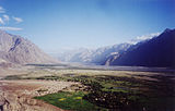 View from Diskit gompa on Nubra Valley
 Seabuckthorn berries, Nubra valley, Ladakh
 Bactrian camels
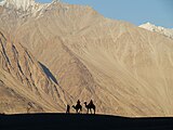 Silhoutte taken at Nubra Valley
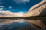 This is enroute town called Hunder in the Nubra Valley.
 Nubra Valley with Diskit Gompa and town immediately below and Hunder in the distance
 Resort in Nubra Valley


ഇതും കാണുക
- Ladakh
- Khardung La
- Siachen Glacier
- Thoise
- Chalunka
- Project HIMANK, road builders in the valley and creaters of curious sign boards
- Disket
അവലംബങ്ങൾ
ബാഹ്യ ലിങ്കുകൾ
Wikiwand in your browser!
Seamless Wikipedia browsing. On steroids.
Every time you click a link to Wikipedia, Wiktionary or Wikiquote in your browser's search results, it will show the modern Wikiwand interface.
Wikiwand extension is a five stars, simple, with minimum permission required to keep your browsing private, safe and transparent.