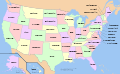
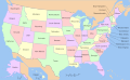
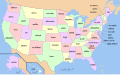
File:Yhdysvaltain_osavaltiot.svg
From Wikipedia, the free encyclopedia

Original file (SVG file, nominally 959 × 593 pixels, file size: 309 KB)
This file is from Wikimedia Commons and may be used by other projects. The description on its file description page there is shown below.
- Suomi: Yhdysvaltain osavaltiot
- English: A map of the United States, with state names in Finnish
| This file is licensed under the Creative Commons Attribution-Share Alike 3.0 Unported license. Subject to disclaimers. | ||
| ||
| This licensing tag was added to this file as part of the GFDL licensing update.http://creativecommons.org/licenses/by-sa/3.0/CC BY-SA 3.0Creative Commons Attribution-Share Alike 3.0truetrue |

|
Permission is granted to copy, distribute and/or modify this document under the terms of the GNU Free Documentation License, Version 1.2 or any later version published by the Free Software Foundation; with no Invariant Sections, no Front-Cover Texts, and no Back-Cover Texts. A copy of the license is included in the section entitled GNU Free Documentation License. Subject to disclaimers.http://www.gnu.org/copyleft/fdl.htmlGFDLGNU Free Documentation Licensetruetrue |
- You are free:
- to share – to copy, distribute and transmit the work
- to remix – to adapt the work
- Under the following conditions:
- attribution – You must give appropriate credit, provide a link to the license, and indicate if changes were made. You may do so in any reasonable manner, but not in any way that suggests the licensor endorses you or your use.
- share alike – If you alter, transform, or build upon this work, you must distribute the resulting work under the same license as the original.
- You are free:
- to share – to copy, distribute and transmit the work
- to remix – to adapt the work
- Under the following conditions:
- attribution – You must give appropriate credit, provide a link to the license, and indicate if changes were made. You may do so in any reasonable manner, but not in any way that suggests the licensor endorses you or your use.
- share alike – If you remix, transform, or build upon the material, you must distribute your contributions under the same or compatible license as the original.
Translated from Map of USA with state names.svg. It was originally uploaded to the English Wikipedia with the same title by w:User:Wapcaplet:
- 20:57, 9 October 2005 . . Dbenbenn . . 959x593 (339217 bytes) (fix South Carolina label)
- 20:27, 9 October 2005 . . Dbenbenn . . 959x593 (339227 bytes) (typo, Massachussetts -> Massachusetts)
- 19:01, 9 October 2005 . . Dbenbenn . . 959x593 (371653 bytes) (crop, and remove some shapes (rivers, highways, capitals, lakes) that didn't display anyway)
- 13:18, 23 September 2005 . . Ed g2s . . 990x855 (978668 bytes) (fix (removed <image /> tag))
- 23:48, 23 September 2004 . . Wapcaplet . . 0x0 (978926 bytes) (SVG map of the United States. Created by Wapcaplet. {{GFDL}})
[takatā]
Multilingual:
 |
 |
 |
 |
 |
 |
 |
 |
 |
 |
 |
 |
 |
 |
 |
 |
 |
 |
 |
 |
 |
 |
 |
 |
 |
 |
 |
 |
 |
 |
 |
 |
 |
 |
 |
 |
 |
 |
 |
 |
 |
 |
 |
 |
 |
 |
 |
 |
 |
 |
 |
 |
 |
 |
 |
 |
 |
 |
 |
 |
 |
 |
 |
 |
 |
 |
 |
 |
 |
 |
 |
 |
 |
 |
 |
 |
 |
 |
 |
 |
 |
 |
 |
 |
 |
 |
 |
 |
 |
 |
 |
 |
 |
 |
 |
 |
 |
 |
 |
 |
 |
 |
 |
 |
 |
 |
 |
 |
 |
 |
 |
 |
 |
 |
 |
 |
 |
 |
 |
 |
 |
 |
 |
 |
 |
 |
 |
 |
 |
 |
 |
 |
 |
 |
 |
 |
 |
 |
 |
 |
 |
 |
 |
 |
 |
 |
 |
 |
 |
 |
 |
Other files:
-
 American sign language
 -
 anarâškielâ
 -
 bosanski
 -
 Diné bizaad
 -
 eesti
eesti -
 English (and mulilingual)
 -
 English
 -
 español
 -
 Esperanto
 -
 euskara
 -
 français
 -
 galego
 -
 Hawaiʻi
 -
 hrvatski
 -
 italiano
 -
 magyar
 -
 occitan PNG
 -
 polski
 -
 português
 -
 română
 -
 Scots
Scots -
 slovenčina
 -
 suomi
suomi -
 svenska
 -
 ślůnski
 -
 Ἀρχαία ἑλληνικὴ
 -
 Ελληνικά
 -
 български
 -
 македонски
 -
 нохчийн
 -
 русский
 -
 русский 2
 -
 српски (ћирилица)
 -
 українська
 -
 ქართული PNG
 -
 қазақша
 -
 मराठी
मराठी -
 हिन्दी
 -
 অসমীয়া
 -
 বাংলা
বাংলা -
 বিষ্ণুপ্রিয়া মণিপুরী
 -
 ਪੰਜਾਬੀ
 -
 മലയാളം
 -
 ไทย
ไทย -
 ᏣᎳᎩ
ᏣᎳᎩ -
 中文(简体)
 -
 中文(繁體)
 -
 עברית
עברית -
 اردو
اردو -
 العربية
 -
 فارسی
فارسی -
 فارسی JPG


.svg)


Captions
Items portrayed in this file
depicts Ingarihi
copyright status Ingarihi
copyrighted Ingarihi
copyright license Ingarihi
File history
Click on a date/time to view the file as it appeared at that time.
| Date/Time | Thumbnail | Dimensions | User | Comment | |
|---|---|---|---|---|---|
| current | 21:17, 9 Hune 2006 | | 959 × 593 (309 KB) | Hautala | * {{fi|Yhdysvaltain osavaltiot}} * {{en|A map of the United States, with state names in Finnish}} {{GFDL-en}}{{cc-by-2.0}}{{cc-by-sa-1.0}}{{cc-by-sa-2.0}} Translated from Image:Map of USA with state names.svg. It was originally uploaded to the Eng |
File usage
Kāhore kau ngā whārangi e whai hoto ana ki tēnei kōnae whakaahua.
Global file usage
The following other wikis use this file:
Metadata
This file contains additional information, probably added from the digital camera or scanner used to create or digitize it.
If the file has been modified from its original state, some details may not fully reflect the modified file.
| Width | 958.69 |
|---|---|
| Height | 592.79 |