File:Angola_map.png
From Wikipedia, the free encyclopedia
Angola_map.png (326 × 351 pixels, file size: 11 KB, MIME type: image/png)
This file is from Wikimedia Commons and may be used by other projects. The description on its file description page there is shown below.
| This file is an original and may be obsolete for general use, but is kept for historical or archival use. As such, it should not be modified or deleted except to correct upload or technical errors. Any modified versions or replacements of this image should be uploaded with a different file name. Information about this file: 2004 version العربيَّة ∙ čeština ∙ Deutsch ∙ English ∙ español ∙ فارسی ∙ français ∙ magyar ∙ italiano ∙ 日本語 ∙ Lëtzebuergesch ∙ македонски ∙ മലയാളം ∙ Nederlands ∙ português ∙ русский ∙ slovenščina ∙ svenska ∙ 简体中文 ∙ 繁體中文 ∙ 正體中文(臺灣) ∙ +/− |
Summary
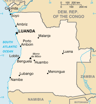
| DescriptionAngola map.png | Angola map from CIA World Factbook, converted from original GIF format |
| Date | |
| Source | CIA World Factbook |
| Author | United States Central Intelligence Agency |
Licensing
| Public domainPublic domainfalsefalse |
This image is in the public domain because it contains materials that originally came from the United States Central Intelligence Agency's World Factbook.
Bahasa Indonesia ∙ čeština ∙ Deutsch ∙ eesti ∙ English ∙ español ∙ Esperanto ∙ français ∙ galego ∙ hrvatski ∙ italiano ∙ Nederlands ∙ norsk nynorsk ∙ polski ∙ português ∙ sicilianu ∙ slovenščina ∙ suomi ∙ Türkçe ∙ Zazaki ∙ беларуская (тарашкевіца) ∙ македонски ∙ русский ∙ српски / srpski ∙ українська ∙ ქართული ∙ বাংলা ∙ தமிழ் ∙ മലയാളം ∙ 한국어 ∙ 日本語 ∙ 中文 ∙ 中文(简体) ∙ 中文(繁體) ∙ العربية ∙ +/− |
 |
Captions
Items portrayed in this file
depicts Ingarihi
inception Ingarihi
15 Haratua 2005
media type Ingarihi
image/png
checksum Ingarihi
147ce79ba9c8a2ff5e7acfc96fb187b3803f2a0f
data size Ingarihi
11,147 byte
height Ingarihi
351 tongiiti
width Ingarihi
326 tongiiti
File history
Click on a date/time to view the file as it appeared at that time.
| Date/Time | Thumbnail | Dimensions | User | Comment | |
|---|---|---|---|---|---|
| current | 19:05, 30 Oketopa 2021 | | 326 × 351 (11 KB) | Auguel | Remove border |
| 12:12, 15 Mei 2005 |  | 330 × 354 (11 KB) | Nord68 | {{PD-USGov-CIA-WF}} |
File usage
The following page uses this file:
Global file usage
The following other wikis use this file:
- Usage on ar.wikipedia.org
- Usage on arz.wikipedia.org
- Usage on ast.wikipedia.org
- Usage on azb.wikipedia.org
- Usage on az.wikipedia.org
- Usage on ban.wikipedia.org
- Usage on bs.wikipedia.org
- Usage on ca.wikipedia.org
- Luanda
- Frontera entre Angola i la República Democràtica del Congo
- Frontera entre Angola i Zàmbia
- Llista d'aeroports d'Angola
- Llista de ciutats d'Angola
- Resolució 1045 del Consell de Seguretat de les Nacions Unides
- Resolució 1294 del Consell de Seguretat de les Nacions Unides
- Resolució 1348 del Consell de Seguretat de les Nacions Unides
- Llista de governadors colonials d'Angola
- Mòdul:Location map/data/Angola
- Mòdul:Location map/data/Angola/ús
- Usage on ckb.wikipedia.org
- Usage on cy.wikipedia.org
- Usage on dag.wikipedia.org
- Usage on da.wikipedia.org
- Usage on de.wikipedia.org
- Usage on diq.wikipedia.org
- Usage on dsb.wikipedia.org
- Usage on el.wikipedia.org
- Usage on en.wikipedia.org
View more global usage of this file.
Metadata
This file contains additional information, probably added from the digital camera or scanner used to create or digitize it.
If the file has been modified from its original state, some details may not fully reflect the modified file.
| Software used | Adobe Photoshop 22.3 (Windows) |
|---|---|
| Date and time of digitizing | 22:58, 30 Oketopa 2021 |
| File change date and time | 23:05, 30 Oketopa 2021 |
| Date metadata was last modified | 23:05, 30 Oketopa 2021 |
| Unique ID of original document | xmp.did:6db654fe-3a0c-0c43-bfd0-f19aba82c9ef |
| Horizontal resolution | 28.35 dpc |
| Vertical resolution | 28.35 dpc |