File:Europe_countries_map_en.png
From Wikipedia, the free encyclopedia
Šī priekšskata izmērs: 737 × 600 pikseļi. Citi izmēri: 295 × 240 pikseļi | 590 × 480 pikseļi | 944 × 768 pikseļi | 1 259 × 1 024 pikseļi | 1 475 × 1 200 pikseļi.
Sākotnējais fails (1 475 × 1 200 pikseļi, faila izmērs: 612 KB, MIME tips: image/png)
| Šis fails ir no Vikikrātuves. Tā apraksts no attēla lapas Vikikrātuvē ir parādīts zemāk. Vikikrātuve ir brīvi licencēta failu krātuve. Tu vari tai palīdzēt. |
Kopsavilkums
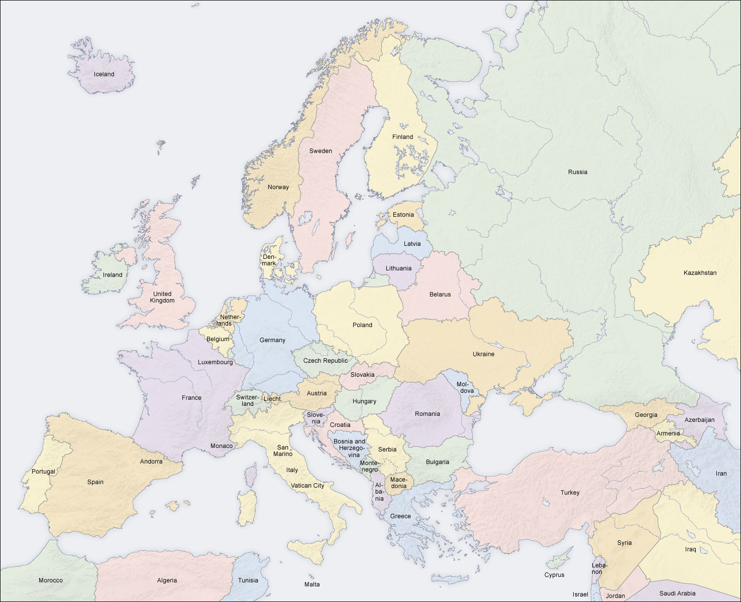
| AprakstsEurope countries map en.png |
English: Map of countries in Europe |
||||||||||
| Datums | 02.04.2006 | ||||||||||
| Avots | Paša darbs (Original text: own map, based on the Generic Mapping Tools and ETOPO2) | ||||||||||
| Autors | San Jose (map) | ||||||||||
| Atļauja: (Šī faila izmantošana citur) |
|
||||||||||
| Citas versijas |
Derivative works of this file:
|


|
This map of europe image could be re-created using vector graphics as an SVG file. This has several advantages; see Commons:Media for cleanup for more information. If an SVG form of this image is available, please upload it and afterwards replace this template with
{{vector version available|new image name}}.
It is recommended to name the SVG file “Europe countries map en.svg”—then the template Vector version available (or Vva) does not need the new image name parameter. |
See also
_en.png)
.png)
.jpg)
Captions
Pievieno vienas rindiņas aprakstu, ko šis fails attēlo
Šajā failā attēlotais
attēlo
Faila hronoloģija
Uzklikšķini uz datums/laiks kolonnā esošās saites, lai apskatītos, kā šis fails izskatījās tad.
| Datums/Laiks | Attēls | Izmēri | Dalībnieks | Komentārs | |
|---|---|---|---|---|---|
| tagadējais | 2018. gada 3. marts, plkst. 17.49 | | 1 475 × 1 200 (612 KB) | Wiz9999 | Reverted to version as of 08:37, 12 June 2008 (UTC) - Please use File:Europe countries map en 2.png to show disputed land. |
| 2017. gada 22. novembris, plkst. 20.07 |  | 1 475 × 1 200 (1,32 MB) | Мечников | update | |
| 2008. gada 12. jūnijs, plkst. 11.37 |  | 1 475 × 1 200 (612 KB) | San Jose | update | |
| 2006. gada 5. jūnijs, plkst. 14.52 |  | 1 475 × 1 200 (658 KB) | San Jose | updated and corrected | |
| 2006. gada 4. jūnijs, plkst. 17.58 |  | 1 475 × 1 200 (611 KB) | Roke~commonswiki | montenegro independent now | |
| 2006. gada 2. aprīlis, plkst. 14.14 |  | 1 475 × 1 200 (661 KB) | San Jose | Upload |
Faila lietojums
Šo failu neizmanto nevienā lapā.
Globālais faila lietojums
Šīs Vikipēdijas izmanto šo failu:
- Izmantojums da.wikipedia.org
- Izmantojums de.wikipedia.org
- Izmantojums en.wikipedia.org
- Izmantojums haw.wikipedia.org
- Izmantojums he.wikipedia.org
- Izmantojums hyw.wikipedia.org
- Izmantojums ilo.wikipedia.org
- Izmantojums nl.wikinews.org
- Izmantojums pag.wikipedia.org
- Izmantojums roa-rup.wikipedia.org
- Izmantojums ro.wikipedia.org
- Izmantojums simple.wiktionary.org
- Izmantojums su.wikipedia.org
- Izmantojums ta.wikipedia.org
- Izmantojums uk.wikipedia.org
Metadati
Šis fails satur papildu informāciju, kuru, visticamāk, ir pievienojis digitālais fotoaparāts vai skeneris, ar ko veidots fails. Ja šis fails pēc tam ir ticis modificēts, šie dati var neatbilst izmaiņām (var būt novecojuši).
| Lietotā programma |
|
|---|
Saturs iegūts no "https://lv.wikipedia.org/wiki/Attēls:Europe_countries_map_en.png"