File:Europe_1878_map_de.png
From Wikipedia, the free encyclopedia
Šī priekšskata izmērs: 800 × 526 pikseļi. Citi izmēri: 320 × 211 pikseļi | 640 × 421 pikseļi | 1 024 × 674 pikseļi | 1 280 × 842 pikseļi | 2 284 × 1 503 pikseļi.
Sākotnējais fails (2 284 × 1 503 pikseļi, faila izmērs: 1,01 MB, MIME tips: image/png)
| Šis fails ir no Vikikrātuves. Tā apraksts no attēla lapas Vikikrātuvē ir parādīts zemāk. Vikikrātuve ir brīvi licencēta failu krātuve. Tu vari tai palīdzēt. |
Kopsavilkums
| AprakstsEurope 1878 map de.png |
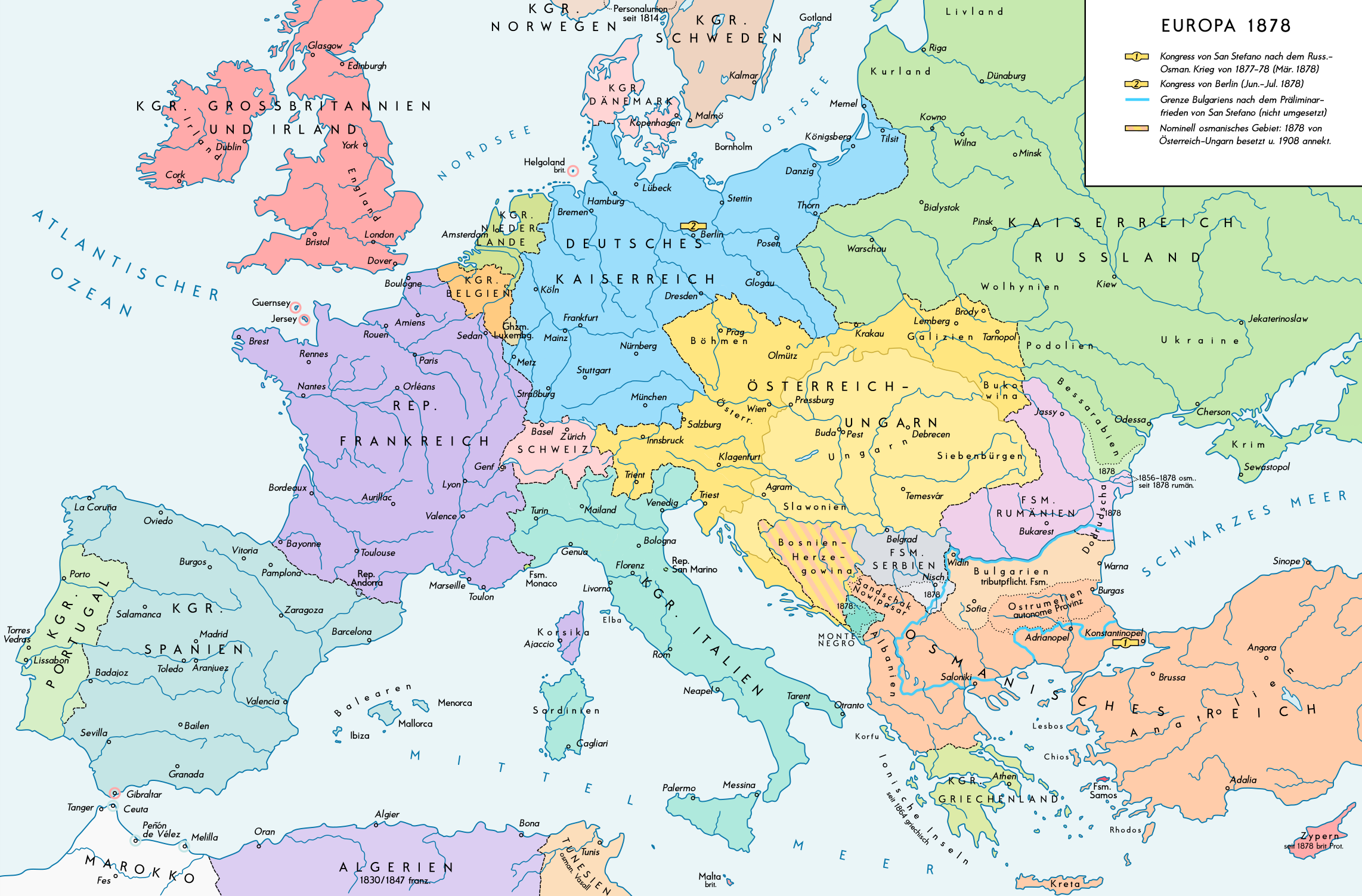
English: Europe 1878. Historical map of the political situation after the Congress of Berlin and the territorial and political rearrangement of the Balkan Peninsula. Please don't alter the map, when you think there something not written or depicted correctly. Leave a message at the talk page of the file. After a verificiation and a possible discussion, i will upload a new map version with all new changes. This prevents an unnecessary waste of disc space and ensures a good result, aesthetically and contentwise. - The author. Deutsch: Europa 1878. Historische Karte der politischen Situation nach dem Berliner Kongress und der politischen und territorialen Neuordnung des Balkans. Bitte die Karte bei Änderungs- und Korrekturwünschen nicht selbst verändern, sondern eine Anmerkung im Diskussionsbereich der Bilddatei hinterlassen. Nach einer Prüfung und ggfs. Diskussion werden evtl. Änderungen von mir zusammengefasst eingearbeitet. Das vermeidet unnötige Speicherplatz-Verschwendung und gewährleistet ein ästhetisch ansprechendes und inhaltlich korrektes Ergebnis. - Der Urheber. |
| Datums | |
| Avots |
Paša darbs. Source of Information: Historical atlases and maps – Ramsay Muir, George Philip (ed.): Philip's New School Atlas of Universal History, George Philip & Son, Ltd., London 1928 – Dr. Walter Leisering (ed.): Putzger Historischer Weltatlas, Cornelsen Verlag, Berlin 1992, ISBN 3-464-00176-8 – Bayerischer Schulbuch-Verlag (ed.): Großer Historischer Weltatlas, Dritter Teil, Neuzeit, Bayerischer Schulbuch-Verlag, München 1981, ISBN 3-7627-6021-7. – Prof. Dr. Vadim Oswalt u. Prof. Dr. Hans Ulrich Rudolf (ed.): Klett-Perthes Atlas zur Weltgeschichte, Ernst Klett Verlag, Stuttgart 2011, ISBN 978-3-12-828194-0 |
| Autors | Alexander Altenhof |
| Citas versijas |
|

Recompressed without quality loss with OptiPNG (1.28 MB > 1.00 MB)
Licence
Es, šī darba autortiesību īpašnieks, publicēju to saskaņā ar šo licenci:
This file is licensed under the Creative Commons Attribution-Share Alike 4.0 International license.
- Jūs varat brīvi:
- koplietot – kopēt, izplatīt un pārraidīt darbu
- remiksēt – pielāgot darbu
- Saskaņā ar šādiem nosacījumiem:
- atsaucoties – Tev ir jānorāda autors, saite uz licenci un to, vai veiktas kādas izmaiņas. To var darīt jebkādā saprātīgā veidā, bet ne tādā, kas norādītu, ka licencētājs atbalsta tevi vai veidu, kā tu izmanto šo darbu.
- nemainot licenci – Ja tu miksē, pārveido vai izmanto materiālu, tev savs devums jāpublicē ar to pašu vai saderīgu licenci kā oriģināls.
Captions
Pievieno vienas rindiņas aprakstu, ko šis fails attēlo
Šajā failā attēlotais
attēlo
Šai īpašībai ir vērtība, bet tā ir nezināma
11 septembris 2016
image/png
Faila hronoloģija
Uzklikšķini uz datums/laiks kolonnā esošās saites, lai apskatītos, kā šis fails izskatījās tad.
| Datums/Laiks | Attēls | Izmēri | Dalībnieks | Komentārs | |
|---|---|---|---|---|---|
| tagadējais | 2017. gada 15. aprīlis, plkst. 02.53 | | 2 284 × 1 503 (1,01 MB) | KaterBegemot | Minor changes |
| 2016. gada 11. septembris, plkst. 01.35 |  | 2 284 × 1 503 (1 023 KB) | KaterBegemot | {{Information |Description ={{en|1=Europe 1878. Historical map of the political situation after the Congress of Berlin and the territorial and political rearrangement of the Balkan Peninsula.<br> ''Please don't alter the map, when you think there so... |
Faila lietojums
Šo failu neizmanto nevienā lapā.
Globālais faila lietojums
Šīs Vikipēdijas izmanto šo failu:
- Izmantojums de.wikipedia.org
- Izmantojums lt.wikipedia.org
- Izmantojums lt.wikibooks.org
- Izmantojums zh.wikipedia.org
Metadati
Šis fails satur papildu informāciju, kuru, visticamāk, ir pievienojis digitālais fotoaparāts vai skeneris, ar ko veidots fails. Ja šis fails pēc tam ir ticis modificēts, šie dati var neatbilst izmaiņām (var būt novecojuši).
| Horizontālā izšķirtspēja | 70 dpi |
|---|---|
| Vertikālā izšķirtspēja | 70 dpi |
| Krāsu telpa | Nekalibrēts |
| Attēla platums | 2 284 px |
| Attēla augstums | 1 503 px |
| Lietotā programma | Adobe Photoshop CC 2017 (Windows) |
| Attēla izveidošanas datums un laiks | 2017. gada 8. aprīlis, plkst. 14.45 |
| Attēla pēdējās izmainīšanas datums un laiks | 2017. gada 15. aprīlis, plkst. 03.27 |
| Date metadata was last modified | 2017. gada 15. aprīlis, plkst. 03.27 |
| Sākotnējā dokumenta unikālais ID | xmp.did:dd077bf2-bd99-fb40-8c20-266ee80cfa99 |
Saturs iegūts no "https://lv.wikipedia.org/wiki/Attēls:Europe_1878_map_de.png"