Attēls:Chile-Chonos_Archipelago.jpg
From Wikipedia, the free encyclopedia
Sākotnējais fails (1 032 × 1 276 pikseļi, faila izmērs: 572 KB, MIME tips: image/jpeg)
| Šis fails ir no Vikikrātuves. Tā apraksts no attēla lapas Vikikrātuvē ir parādīts zemāk. Vikikrātuve ir brīvi licencēta failu krātuve. Tu vari tai palīdzēt. |
Kopsavilkums
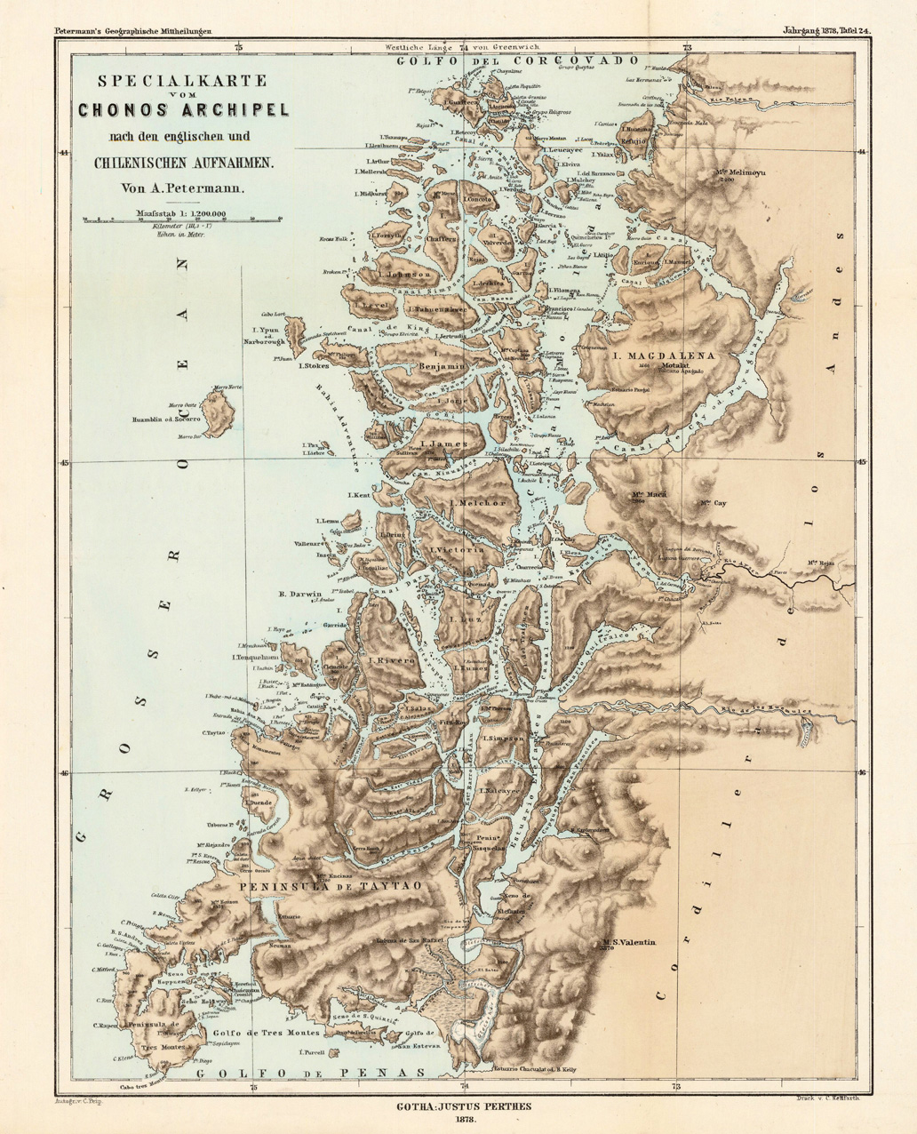
| AprakstsChile-Chonos Archipelago.jpg |
English: Lithograph, printed in colors when published. Detailled map, showing the Chonos Archipel from the gulf of Penas with the Peninsula de Taytao up to the gulf of Corcovado. Very detailled map with an enormous number of islands and peninsulas, most of them with place names. The map provides an overview of the results of the travel by Th. von Heugelin to Somalia. It is also ornated with a scene of birds and mammals, which were discovered by Th. Heugelin in Somalia. |
| Datums | |
| Avots | http://www.bergbook.com/htdocs/woda/data/demo/descriptions/17333.htm |
| Autors | Petermann, A. |
Licence
| Public domainPublic domainfalsefalse |
|
This work is in the public domain in its country of origin and other countries and areas where the copyright term is the author's life plus 70 years or fewer.
| |
| This file has been identified as being free of known restrictions under copyright law, including all related and neighboring rights. | |
https://creativecommons.org/publicdomain/mark/1.0/PDMCreative Commons Public Domain Mark 1.0falsefalse
Captions
Šajā failā attēlotais
attēlo
1878
image/jpeg
checksum angļu
b29053ce8721299e9075c7c182899f91f1f07ad8
data size angļu
585 964 Baits
1 276 pikselis
1 032 pikselis
Faila hronoloģija
Uzklikšķini uz datums/laiks kolonnā esošās saites, lai apskatītos, kā šis fails izskatījās tad.
| Datums/Laiks | Attēls | Izmēri | Dalībnieks | Komentārs | |
|---|---|---|---|---|---|
| tagadējais | 2010. gada 24. februāris, plkst. 05.43 | | 1 032 × 1 276 (572 KB) | Rec79 | {{Information |Description={{en|1=Lithograph, printed in colors when published. Detailled map, showing the Chonos Archipel from the gulf of Penas with the Peninsula de Taytao up to the gulf of Corcovado. Very detailled map with an enormous number of islan |
Faila lietojums
Šo failu izmanto šajā 1 lapā:
Globālais faila lietojums
Šīs Vikipēdijas izmanto šo failu:
- Izmantojums bar.wikipedia.org
- Izmantojums ca.wikipedia.org
- Izmantojums de.wikipedia.org
- Izmantojums en.wikipedia.org
- Izmantojums es.wikipedia.org
- Izmantojums fr.wikipedia.org
- Izmantojums fr.wiktionary.org
- Izmantojums gl.wikipedia.org
- Izmantojums it.wikipedia.org
- Izmantojums lt.wikipedia.org
- Izmantojums nn.wikipedia.org
- Izmantojums ru.wikipedia.org
- Izmantojums sh.wikipedia.org
- Izmantojums www.wikidata.org
Metadati
Šis fails satur papildu informāciju, kuru, visticamāk, ir pievienojis digitālais fotoaparāts vai skeneris, ar ko veidots fails. Ja šis fails pēc tam ir ticis modificēts, šie dati var neatbilst izmaiņām (var būt novecojuši).
| _error | 0 |
|---|