Attēls:World_in_400_CE.png
From Wikipedia, the free encyclopedia
Šī priekšskata izmērs: 800 × 407 pikseļi. Citi izmēri: 320 × 163 pikseļi | 640 × 326 pikseļi | 1 024 × 521 pikseļi | 1 280 × 652 pikseļi | 4 000 × 2 036 pikseļi.
Sākotnējais fails (4 000 × 2 036 pikseļi, faila izmērs: 1,71 MB, MIME tips: image/png)
| Šis fails ir no Vikikrātuves. Tā apraksts no attēla lapas Vikikrātuvē ir parādīts zemāk. Vikikrātuve ir brīvi licencēta failu krātuve. Tu vari tai palīdzēt. |
Kopsavilkums
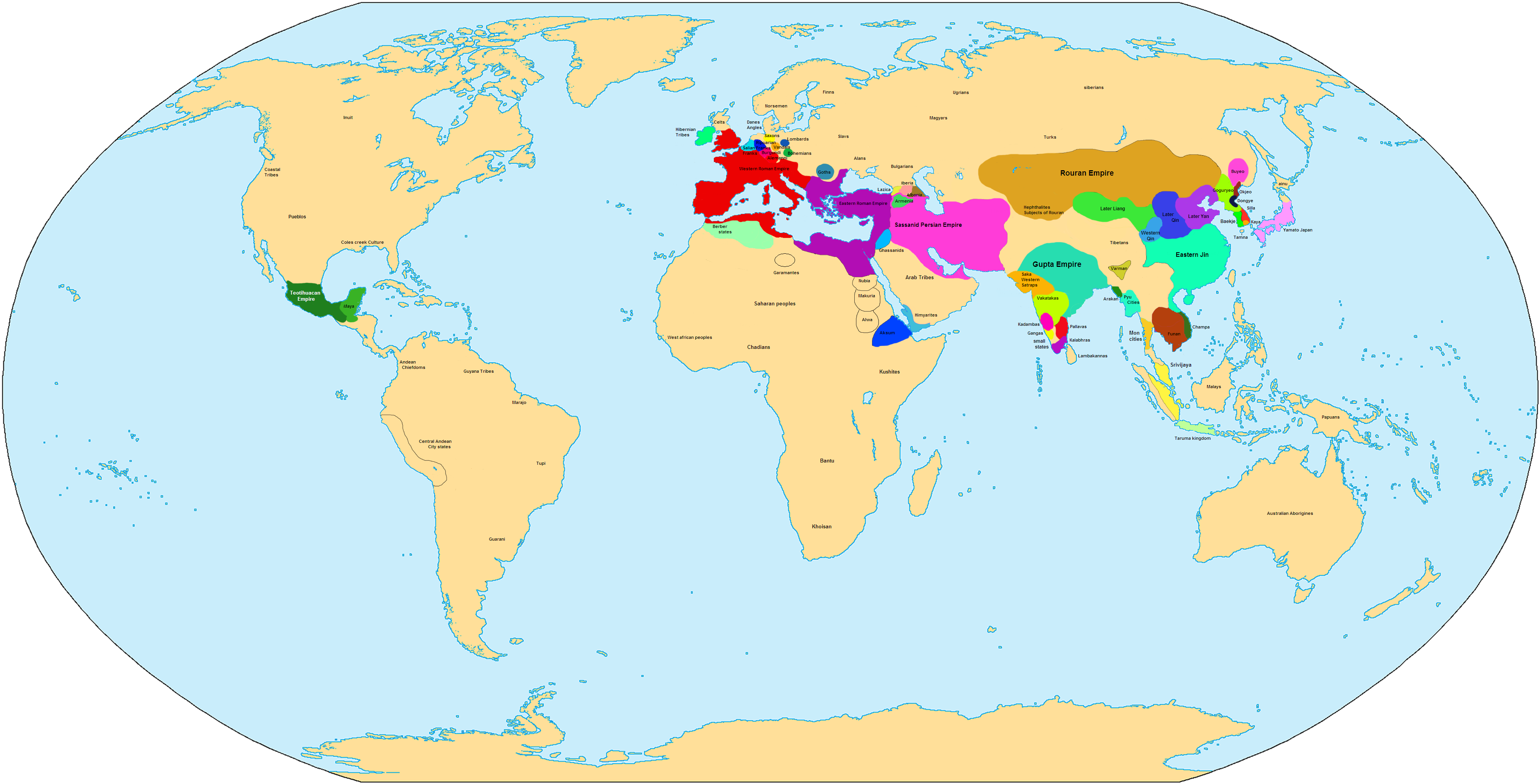
| AprakstsWorld in 400 CE.png | Map showing the world in 400 CE. |
| Avots | Paša darbs |
| Autors | Javierfv1212 |

|
This historical map image could be re-created using vector graphics as an SVG file. This has several advantages; see Commons:Media for cleanup for more information. If an SVG form of this image is available, please upload it and afterwards replace this template with
{{vector version available|new image name}}.
It is recommended to name the SVG file “World in 400 CE.svg”—then the template Vector version available (or Vva) does not need the new image name parameter. |
| Maps of world history | |
| BC | |
|
| |
| AD |
1 · 50 · 100 · 200 · 250 · 300 · 400 · 500 · 700 · 750 · 820 · 900 · 1200 · 1500 · 1556 · 1648 · 1700 · 1750 · 1815 · 1859 · 1871 · 1914 · 1935 · 1954 · 1989 · 2000 · |
|
Maps of colonization history | |
|
see also: Eastern Hemisphere only maps template (1300BC-1500AD) | |
| (this template: · view · discuss ) | |
.jpg)
._LOC_2001620596.jpg)
Licence
| Public domainPublic domainfalsefalse |
| I, the copyright holder of this work, release this work into the public domain. This applies worldwide. In some countries this may not be legally possible; if so: I grant anyone the right to use this work for any purpose, without any conditions, unless such conditions are required by law. |
| Annotations InfoField | This image is annotated: View the annotations at Commons |
1675
150
2088
1486
4000
2036

Captions
Pievieno vienas rindiņas aprakstu, ko šis fails attēlo
Šajā failā attēlotais
attēlo
Šai īpašībai ir vērtība, bet tā ir nezināma
Faila hronoloģija
Uzklikšķini uz datums/laiks kolonnā esošās saites, lai apskatītos, kā šis fails izskatījās tad.
| Datums/Laiks | Attēls | Izmēri | Dalībnieks | Komentārs | |
|---|---|---|---|---|---|
| tagadējais | 2007. gada 4. novembris, plkst. 04.37 | | 4 000 × 2 036 (1,71 MB) | Javierfv1212 | {{Information |Description= |Source=self-made |Date= |Author= Javierfv1212 |Permission= |other_versions= }} Category:Maps of the world showing history |
Faila lietojums
Šo failu neizmanto nevienā lapā.
Globālais faila lietojums
Šīs Vikipēdijas izmanto šo failu:
- Izmantojums de.wikipedia.org
- Izmantojums en.wikipedia.org
- Izmantojums es.wikipedia.org
- Izmantojums fr.wikipedia.org
- Izmantojums lt.wikipedia.org
- Izmantojums sv.wikipedia.org
- Izmantojums uk.wikipedia.org
- Izmantojums zh.wikipedia.org
Saturs iegūts no "https://lv.wikipedia.org/wiki/Attēls:World_in_400_CE.png"