Attēls:Liniadmowskiego.png
From Wikipedia, the free encyclopedia
Augstāka izšķirtspēja nav pieejama.
Liniadmowskiego.png (545 × 600 pikseļi, faila izmērs: 228 KB, MIME tips: image/png)
| Šis fails ir no Vikikrātuves. Tā apraksts no attēla lapas Vikikrātuvē ir parādīts zemāk. Vikikrātuve ir brīvi licencēta failu krātuve. Tu vari tai palīdzēt. |
| AprakstsLiniadmowskiego.png |
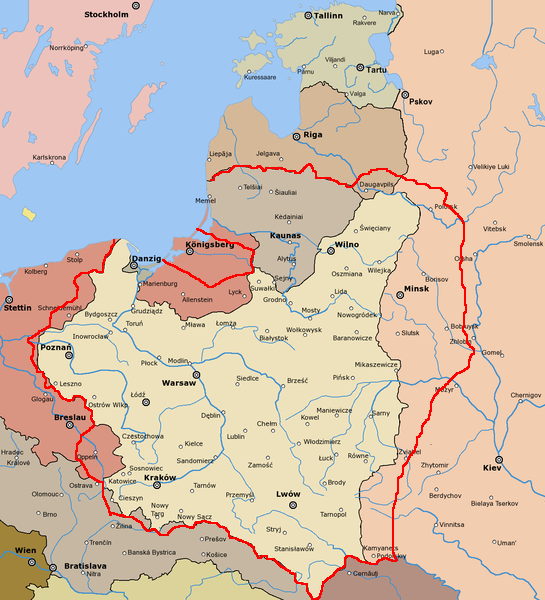
English: Dmowski's Line (borders of Poland proposed during the Paris Peace Conference) Polski: Linia Dmowskiego |
| Datums | |
| Avots |
derivative of File:Rzeczpospolita 1920.png; uploaded to pl wikipedia by Mix321 on 2 Dec 2006 data based on Małkowski, T. Rześniowiecki, J. Historia III, podręcznik dla klasy III gimnazjum, wyd. Gdańskie Wydawnictwo Oświatowe, Gdańsk, 2002 |
| Autors | derivative: Mix321, original: listed below |
| Atļauja: (Šī faila izmantošana citur) |
GFDL |
This image is a derivative work of the following images:
- File:Rzeczpospolita_1920.png licensed with Cc-by-sa-3.0-migrated, GFDL
- 2009-12-05T08:35:28Z DJ Sturm 2000x1534 (369919 Bytes) Correct borders, improved Estonia
- 2009-08-16T14:37:51Z Halibutt 2000x1534 (349775 Bytes) Reverted to version as of 06:33, 8 May 2005 (don't do this. Modify the svg version instead, without those horrible colours and copy-paste leftovers)
- 2009-03-27T14:30:53Z DJ Sturm 2000x1534 (368552 Bytes) Fixed borders of Estonia, Latvia, Lithuania, Soviet Union and Germany, added some towns.
- 2005-05-08T06:33:43Z Halibutt 2000x1534 (349775 Bytes) Reverted to earlier revision
- 2005-05-07T21:41:55Z DeirYassin 2000x1534 (314976 Bytes) Corrected borders of Latvia and Russia, Estonia and Russia according to real interwar, rather than current, borders; the Lithuanian claim is shown.
- 2005-05-07T20:50:35Z DeirYassin 2000x1534 (314976 Bytes)
- 2005-05-07T20:47:17Z DeirYassin 2000x1534 (314976 Bytes)
- 2005-04-07T21:04:53Z Halibutt 2000x1534 (349775 Bytes) New additions: borders of Czechoslovakia corrected, new towns added, more changes to follow. Any suggestions?
- 2005-04-05T07:53:46Z Halibutt 2000x1534 (267139 Bytes) Newer version
- 2005-04-04T07:02:24Z Halibutt 2000x1534 (236688 Bytes) new version: Hungaro-Czechoslovak border corrected and town names added
- 2005-04-02T12:06:46Z Halibutt 2000x1534 (148548 Bytes) new version, colours added
- 2005-04-02T05:30:08Z Halibutt 2000x1534 (151894 Bytes) Early version of my map of Poland and Eastern Europe between 1918 and 1945. So far it features the borders and major towns and cities, as well as the frontlines of the [[Polish-Bolshevik War]]. The colours and fonts and other

|
Ir dota atļauja kopēt, izplatīt un/vai pārveidot šo dokumentu saskaņā ar GNU brīvās dokumentācijas licences, versijas 1.2 vai jebkuras vēlākas versijas, ko publiskojis Brīvās programmatūras fonds nosacījumiem; bez nemainīgajām sadaļā, priekšējā un aizmugurēja'vāka tekstiem. Licences kopija ir iekļauta sadaļā ar nosaukumu GNU brīvās dokumentācijas licence.http://www.gnu.org/copyleft/fdl.htmlGFDLGNU Free Documentation Licensetruetrue |
| Šis fails tiek izplatīts saskaņā ar licences Creative Commons Atsauce-Līdzīgi Noteikumi 3.0 Vispārējiem noteikumiem. | ||
| ||
| This licensing tag was added to this file as part of the GFDL licensing update.http://creativecommons.org/licenses/by-sa/3.0/CC BY-SA 3.0Creative Commons Attribution-Share Alike 3.0truetrue |
Captions
Pievieno vienas rindiņas aprakstu, ko šis fails attēlo
Šajā failā attēlotais
attēlo
2 decembris 2006
Faila hronoloģija
Uzklikšķini uz datums/laiks kolonnā esošās saites, lai apskatītos, kā šis fails izskatījās tad.
| Datums/Laiks | Attēls | Izmēri | Dalībnieks | Komentārs | |
|---|---|---|---|---|---|
| tagadējais | 2010. gada 20. oktobris, plkst. 11.46 | | 545 × 600 (228 KB) | Mixx321 | dr |
| 2009. gada 15. decembris, plkst. 18.05 |  | 514 × 496 (171 KB) | Piotrus | {{Information |Description=:en: Dmowski's Line (borders of Poland proposed during the Paris Peace Conference)<br>:pl: Linia Dmowskiego |Source=uploaded to pl wikipedia by Mix321 on 2 Dec 2006 |Date=2 Dec 2006 |Author=Mix321 |Permi |
Faila lietojums
Šo failu izmanto šajā 1 lapā:
Saturs iegūts no "https://lv.wikipedia.org/wiki/Attēls:Liniadmowskiego.png"