File:Nazi_Germany.png
From Wikipedia, the free encyclopedia
Gruutde van dees veurvertuining: 772 × 600 pixels. Anger resoluties: 309 × 240 pixels | 618 × 480 pixels | 989 × 768 pixels | 1.200 × 932 pixels.
Oearsprunkelik bestandj ((1.200 × 932 pixel, besjtandsgruutde: 263 kB, MIME type: image/png))
Dit besjtandj kump van Wikimedia Commons en kin ouch in anger projekte gebroek waere. De pagina mit de besjtandjsbesjrieving wurt hiejónger weergegaeve.

|
Bestand:Nazi Germany.svg is een vectorversie van dit bestand. Indien niet van slechtere kwaliteit dient deze gebruikt te worden in plaats van deze rasterafbeelding.
File:Nazi Germany.png → File:Nazi Germany.svg
Zie Help:SVG voor meer informatie.
|
 |
Besjrieving
| BesjrievingNazi Germany.png |
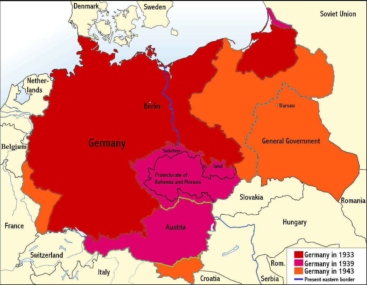
English: An overview map of Nazi Germany to 1943. |
||||||||
| Datum | |||||||||
| Brón | Transferred from the English Wikipedia. Original file is/was here. (Original upload log available below.) | ||||||||
| Sjriever | Wikinist | ||||||||
| Permissie (Hergebroek van dit besjtandj) |
|
||||||||
| Anger versies |
Derivative works of this file: Nazi Germany-it.svg |


Orzjineel uploadlogbook
All the following user names refer to the English Wikipedia.
| Date/Time | Dimensions | User | Comment |
|---|---|---|---|
| 00:03, 24 June 2008 | 1,200×932 (275 KB) |
Wikinist | (Belgia -> Belgium) |
| 00:52, 30 April 2008 | 1,200×932 (286 KB) |
R-41 | (Removed swastika from map. The title "Germany" is moved up to the centre of Germany on the map now.) |
| 21:37, 29 April 2008 | 1,200×932 (291 KB) |
Wikinist | (== Description== {{Information |Description=An overview map of Nazi Germany, based on another map[http://en.wikipedia.org/wiki/Image:GDR.png] by [[:de:Benutzer:kgberger|kgberger]]. Placenames replaced with English ones, resolution decreased, a lot of info) |
Bijschriften
Beschrijf in één regel wat dit bestand voorstelt
Items getoond in dit bestand
beeldt af Nederlands
auteursrechtenstatus Nederlands
auteursrechtelijk beschermd Nederlands
datum van oprichting of creatie Nederlands
30 apr 2008
Besjtandshistorie
Klik op 'ne datum/tied óm 't besjtand te zeen wie 't oetzaog op det tiedsjtip.
| Datum/Tied | Miniatuurplaetje | Aafmaetinge | Gebroeker | Kómmentaar | |
|---|---|---|---|---|---|
| hujig | 7 jun 2009 01:35 | | 1.200 × 932 (263 kB) | MaggotMaster | Reverted to version as of 22:18, 21 May 2009 |
| 4 jun 2009 13:57 |  | 1.200 × 932 (234 kB) | Fz22~commonswiki | {{Information |Description= |Source= |Date= |Author= |Permission= |other_versions= }} | |
| 22 mei 2009 00:18 |  | 1.200 × 932 (263 kB) | Hohum | Reduced garish colour intensity. | |
| 19 jan 2009 11:30 |  | 1.200 × 932 (207 kB) | Brianski | clean up the legend | |
| 8 okt 2008 22:20 |  | 1.200 × 932 (275 kB) | File Upload Bot (Magnus Manske) | {{BotMoveToCommons|en.wikipedia}} {{Information |Description={{en|An overview map of Nazi Germany, based on another map (en::Image:GDR.png) by kgberger. Placenames replaced with English ones, resolution decreased, a lot |
Plaetjesverwiezinge
Gein inkel pazjena gebroek dit plaetje.
Globaal besjtandjsgebroek
De volgende anger wiki's gebroeke dit bestandj:
- Gebroek in la.wikipedia.org
- Gebroek in pt.wikipedia.org
Aafkomstig van Wikipedia, de Vriej Encyclopedie. "https://li.wikipedia.org/wiki/Plaetje:Nazi_Germany.png"