File:France_departements_regions_narrow.jpg
From Wikipedia, the free encyclopedia

Nulla maior resolutio exstat.
France_departements_regions_narrow.jpg (520 × 550 elementa imaginalia, magnitudo fasciculi: 68 chiliocteti, typus MIME: image/jpeg)
Hic fasciculus apud Vicimedia Communia iacet; in aliis inceptis adhiberi potest. Contenta paginae descriptionis fasciculi subter monstrantur.
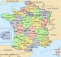
| DescriptioFrance departements regions narrow.jpg | Map of official départements and régions of France, with French titles (in JPEG format for larger, rapid display: 5x faster than SVG). French: Départements et régions, en Francais. | |||
| Datum | ||||
| Fons | Image:Départements+régions (France).svg (Wikimedia file, converted to quick JPEG and narrowed 15%) | |||
| Auctor | self (after User:Historicair 6-Nov-2006) | |||
| Permissio (Reusing this file) |
|
|||
| Other versions | Wider view, large 254kb SVG file: Image:Départements+régions (France).svg |
This map was improved or created by the Wikigraphists of the Graphic Lab (fr). You can propose images to clean up, improve, create or translate as well. |

|
File:Départements+régions (France).svg is a vector version of this file. It should be used in place of this JPG file.
File:France departements regions narrow.jpg → File:Départements+régions (France).svg
For more information, see Help:SVG.
|
.svg) |
Variations
-
 CURRENT IMAGE: Départements 520px (15% magnified, rapid JPEG format)
 -
 Départements 588px (régions en lettres et colorisé, wider view, same labels, SVG format 5x slower)
 -
 Départements sans colorisé (numeric labels, uncolorized)
 -
 Départements de France avec un découpage régional


Captions
Add a one-line explanation of what this file represents
نقشه جغرافیای سیاسی فرانسه همراه با ۲۲ ناحیه و ۹۶ شهرستان
Items portrayed in this file
depicts Anglica
copyright status Anglica
21 Martii 2007
media type Anglica
image/jpeg
Historia fasciculi
Presso die vel tempore fasciculum videbis, sicut tunc temporis apparuit.
| Dies/Tempus | Minutio | Dimensiones | Usor | Sententia | |
|---|---|---|---|---|---|
| recentissima | 13:44, 21 Martii 2007 | | 520 × 550 (68 chiliocteti) | Wikid77 | Circled Paris in maroon red color, to tie inset to Paris region. |
| 12:02, 21 Martii 2007 |  | 520 × 550 (68 chiliocteti) | Wikid77 | {{Information |Description=Map of official départements and régions of France, with French titles (in JPEG format for larger, rapid display: 5x faster than SVG). ''French:'' Départements et régions, en Francais. |Source=[[:Image:Départements+région |
Nexus ad fasciculum
Nullae paginae hoc fasciculo utuntur.
Usus fasciculi per inceptus Vicimediorum
Quae incepta Vici fasciculo utuntur:
- Usus in azb.wikipedia.org
- Usus in be.wikipedia.org
- Usus in ca.wikipedia.org
- Usus in cs.wikipedia.org
- Usus in en.wikipedia.org
- Usus in fa.wikipedia.org
- Usus in fr.wikipedia.org
- Usus in hu.wikipedia.org
- Usus in hy.wikipedia.org
- Usus in id.wikipedia.org
- Usus in ja.wikipedia.org
- Usus in jv.wikipedia.org
- Usus in ka.wikipedia.org
- Usus in km.wikipedia.org
- Usus in my.wikipedia.org
- Usus in mzn.wikipedia.org
- Usus in nn.wikipedia.org
- Usus in sk.wikipedia.org
- Usus in sl.wikipedia.org
- Usus in sr.wikipedia.org
- Usus in sv.wikipedia.org
- Usus in te.wikipedia.org
- Usus in tl.wikipedia.org
- Usus in tr.wiktionary.org
- Usus in tt.wikipedia.org
View more global usage of this file.