File:Ambulante_Kinderhospizdienste_in_Deutschland.PNG
From Wikipedia, the free encyclopedia
Nulla maior resolutio exstat.
Ambulante_Kinderhospizdienste_in_Deutschland.PNG (372 × 444 elementa imaginalia, magnitudo fasciculi: 44 chiliocteti, typus MIME: image/png)
Hic fasciculus apud Vicimedia Communia iacet; in aliis inceptis adhiberi potest. Contenta paginae descriptionis fasciculi subter monstrantur.

|
This health map image could be re-created using vector graphics as an SVG file. This has several advantages; see Commons:Media for cleanup for more information. If an SVG form of this image is available, please upload it and afterwards replace this template with
{{vector version available|new image name}}.
It is recommended to name the SVG file “Ambulante Kinderhospizdienste in Deutschland.svg”—then the template Vector version available (or Vva) does not need the new image name parameter. |
Summarium
| DescriptioAmbulante Kinderhospizdienste in Deutschland.PNG |
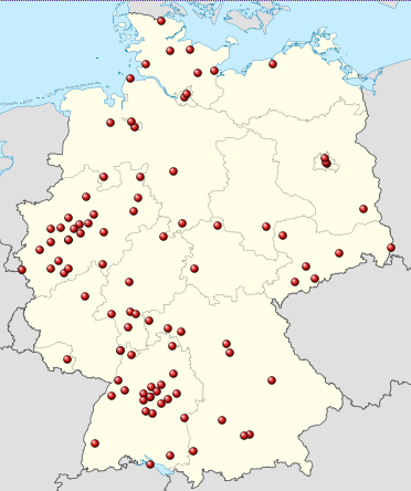
Deutsch: Positionskarte von Deutschland, eingetragen sind die Standorte ambulanter kinderhospizdienste nach DHKV ([1], Stand: März 2012 Quadratische Plattkarte, N-S-Streckung 150 %. Geographische Begrenzung der Karte: * N: 55.1° N * S: 47.2° N * W: 5.5° O * O: 15.5° O English: Location map of Germany Equirectangular projection, N/S stretching 150 %. Geographic limits of the map: * N: 55.1° N * S: 47.2° N * W: 5.5° E * E: 15.5° E Français : Carte de l'Allemagne |
| Datum | (UTC) |
| Fons |
This file was derived from: Germany location map.svg:  |
| Auctor |
|
| This is a retouched picture, which means that it has been digitally altered from its original version. Modifications: Ambulante Kinderhospizdienste eingetragen. The original can be viewed here: Germany location map.svg:
|
Potestas usoris
I, the copyright holder of this work, hereby publish it under the following licenses:
This file is licensed under the Creative Commons Attribution-Share Alike 3.0 Unported license.
- Tibi licet:
- communicare – copiare, distribuere et committere hoc opus
- to remix – to adapt the work
- His condicionibus:
- attributio – You must give appropriate credit, provide a link to the license, and indicate if changes were made. You may do so in any reasonable manner, but not in any way that suggests the licensor endorses you or your use.
- aequa parte – If you remix, transform, or build upon the material, you must distribute your contributions under the same or compatible license as the original.

|
Licet hoc documentum exscribere vel distribuere vel demutare sub GNU Liberarum Litterarum Licentiae conditionibus in editione 1.2 aut in ulla editione recentiori a Fundatione Liberarum Programmationis Partium publicata; praeterquam Sectiones Immutabiles et Verba Involucra Adversa et Aversa. Licentiae exemplar praesto est in sectione intitulata GNU Free Documentation License.http://www.gnu.org/copyleft/fdl.htmlGFDLGNU Free Documentation Licensetruetrue |
Tibi typum permissionis ligere licet.
Original upload log
This image is a derivative work of the following images:
- File:Germany_location_map.svg licensed with Cc-by-sa-3.0, GFDL
- 2010-01-19T10:03:29Z NordNordWest 1073x1272 (502104 Bytes) update
- 2009-07-22T08:33:33Z NordNordWest 1075x1273 (623082 Bytes) c
- 2008-10-13T14:36:44Z NordNordWest 1075x1273 (620685 Bytes)
- 2008-10-09T21:13:47Z NordNordWest 1075x1273 (627868 Bytes) smaller file, data optimized
- 2008-06-30T20:25:05Z NordNordWest 1076x1274 (899543 Bytes) {{Information |Description= {{de|Positionskarte von [[:de:Deutschland|Deutschland]]}} Quadratische Plattkarte, N-S-Streckung 150 %. Geographische Begrenzung der Karte: * N: 55.1° N * S: 47.2° N * W: 5.5° O * O: 15.5° O {{
Uploaded with derivativeFX
Captions
Add a one-line explanation of what this file represents
Items portrayed in this file
depicts Anglica
copyright status Anglica
copyrighted Anglica
19 Martii 2012
media type Anglica
image/png
checksum Anglica
c681fda2c24da74787cdbf1ad13cb6144ff91e18
data size Anglica
44 997 byte
444 pixel
372 pixel
Historia fasciculi
Presso die vel tempore fasciculum videbis, sicut tunc temporis apparuit.
| Dies/Tempus | Minutio | Dimensiones | Usor | Sententia | |
|---|---|---|---|---|---|
| recentissima | 22:19, 19 Martii 2012 | | 372 × 444 (44 chiliocteti) | Gripweed | == {{int:filedesc}} == {{Information |Description={{de|Positionskarte von Deutschland}} Quadratische Plattkarte, N-S-Streckung 150 %. Geographische Begrenzung der Karte: * N: 55.1° N * S: 47.2° N * ... |
Nexus ad fasciculum
Nullae paginae hoc fasciculo utuntur.
Usus fasciculi per inceptus Vicimediorum
Quae incepta Vici fasciculo utuntur:
- Usus in de.wikipedia.org