Fasciculus:Oceanic_gyres.png
From Wikipedia, the free encyclopedia
Nulla maior resolutio exstat.
Oceanic_gyres.png (450 × 294 elementa imaginalia, magnitudo fasciculi: 225 chiliocteti, typus MIME: image/png)
Hic fasciculus apud Vicimedia Communia iacet; in aliis inceptis adhiberi potest. Contenta paginae descriptionis fasciculi subter monstrantur.
Summarium
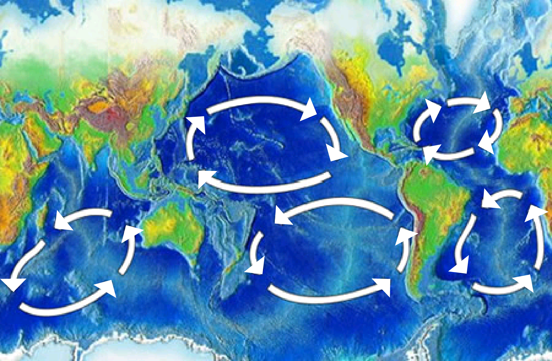
| DescriptioOceanic gyres.png | There are five major ocean-wide gyres — the North Atlantic, South Atlantic, North Pacific, South Pacific, and Indian Ocean gyres. Each is flanked by a strong and narrow “western boundary current,” and a weak and broad “eastern boundary current”. |
| Datum | |
| Fons | here, img |
| Auctor | NOAA |
| Other versions | Image:Pacific oceanic gyres.png |
Potestas usoris
| Public domainPublic domainfalsefalse |
This image is in the public domain because it contains materials that originally came from the U.S. National Oceanic and Atmospheric Administration, taken or made as part of an employee's official duties.
العربية ∙ čeština ∙ Deutsch ∙ Zazaki ∙ English ∙ español ∙ eesti ∙ suomi ∙ français ∙ hrvatski ∙ magyar ∙ italiano ∙ 日本語 ∙ 한국어 ∙ македонски ∙ മലയാളം ∙ Plattdüütsch ∙ Nederlands ∙ polski ∙ português ∙ română ∙ русский ∙ sicilianu ∙ slovenščina ∙ Türkçe ∙ Tiếng Việt ∙ 简体中文 ∙ 繁體中文 ∙ +/− |
Captions
Add a one-line explanation of what this file represents
Il y a 5 grands gyres océaniques : de l'Atlantique Nord, de l'Atlantique Sud, du Pacifique Nord, du Pacifique Sud et de l'océan Indien. Chacun a un courant de frontière ouest, fort et étroit et un courant de frontière est, faible et large.
Items portrayed in this file
depicts Anglica
Historia fasciculi
Presso die vel tempore fasciculum videbis, sicut tunc temporis apparuit.
| Dies/Tempus | Minutio | Dimensiones | Usor | Sententia | |
|---|---|---|---|---|---|
| recentissima | 06:18, 20 Maii 2024 | | 450 × 294 (225 chiliocteti) | Sumanjyot840 | Reverted to version as of 02:47, 5 April 2008 (UTC) |
| 21:46, 12 Decembris 2018 |  | 1 875 × 1 225 (328 chiliocteti) | A loose necktie | Fixing surprisingly unhelopful NOAA map by adding better arrows | |
| 02:47, 5 Aprilis 2008 |  | 450 × 294 (225 chiliocteti) | Jrockley | {{Information |Description=Gyres of the world's oceans |Source=[http://oceanservice.noaa.gov/education/kits/currents/05currents3.html here] |Date=March 25, 2008 |Author=NOAA |Permission= |other_versions= }} Category:Oceans [[Category:Mar |
Nexus ad fasciculum
Ad hunc fasciculum nectunt:
Usus fasciculi per inceptus Vicimediorum
Quae incepta Vici fasciculo utuntur:
- Usus in af.wikipedia.org
- Usus in ar.wikipedia.org
- Usus in bn.wikipedia.org
- Usus in bs.wikipedia.org
- Usus in ca.wikipedia.org
- Usus in da.wikipedia.org
- Usus in de.wikipedia.org
- Usus in de.wikinews.org
- Usus in en.wikipedia.org
- Atlantic Ocean
- History of Portugal (1415–1578)
- Downwelling
- Conquistador
- Ocean gyre
- Kuroshio Current
- Walter Munk
- Great Pacific garbage patch
- Volta do mar
- User:Epipelagic/sandbox/box3
- Wild fisheries
- Ocean
- Indian Ocean Gyre
- Indian Ocean garbage patch
- Marine habitat
- User:GarrettGissinger/sandbox
- User:Daniel Mietchen/gallery
- Beach cleaning
- Template:Oceanic gyres
- Low-nutrient, low-chlorophyll region
View more global usage of this file.