File:Germany_(+districts_+municipalities)_location_map.png
From Wikipedia, the free encyclopedia
Түп нуска файл (5 000 × 5 888 пиксель, файлдын өлчөмү: 1,15 MB, MIME түрү: image/png)
Бул файл Викиказына долбоорунан. Ошондой эле башка долбоорлордо пайдаланылышы мүмкүн. Төмөндө файлды сыпаттоо барагындагы сыпаттамасы көрсөтүлгөн.
Жыйынтыгы
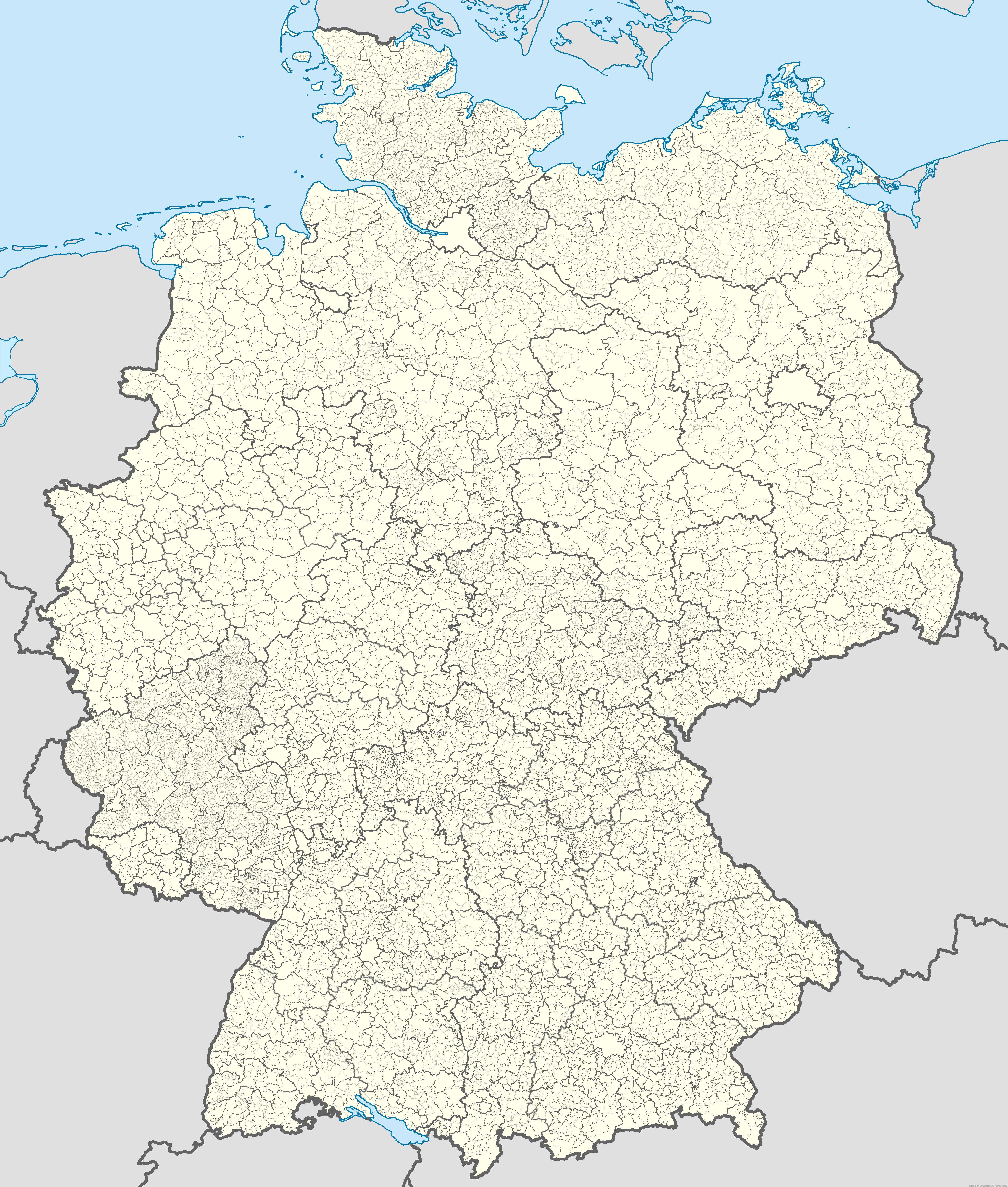
| СыпаттамаGermany (+districts +municipalities) location map.png |
Deutsch: Positionskarte von Deutschland mit Grenzen der Regierungsbezirke, Landkreise, kreisfreien Städte, Kommunen und Kommunalverbände. Stand 1.1.2013.
Quadratische Plattkarte, N-S-Streckung 150 %. Geographische Begrenzung der Karte:
English: Location map of Germany with states, districts, municipalities af of Jan 1st, 2013.
Equirectangular projection, N/S stretching 150 %. Geographic limits of the map:
|
| Дата | |
| Булак |
Өздүк чыгарма This image includes elements that have been taken or adapted from this file: |
| Автор |
TUBS |
| Уруксат (Бул файлды кайрадан колдонуу) |
Please see File:Germany (+districts +municipalities) location map.svg for a recommendation of how to deal with the BKG-attribution. |
| Башка нускалар |
|
| PNG genesis InfoField | This map was created with Adobe Illustrator. |

_location_map.svg)
_location_map_2013.svg)
_location_map.png)
_location_map.svg)
Лицензиялоо
Original data for all borders within Germany: © GeoBasis-DE / BKG 2013 according Verordnung zur Festlegung der Nutzungsbestimmungen für die Bereitstellung von Geodaten des Bundes vom 19. März 2013 (BGBl. I S. 547) (GEoNutzV)
- Сиз буларга эркинсиз:
- бөлүшүү – чыгарманы көчүрүү, жайылтуу жана өткөрүп берүү
- ремикс кылуу – чыгарманы ылайыкташтыруу
- Төмөнкү шарттарда:
- атрибуция – Сиз тийиштүү насыя берип, лицензияга шилтеме калтырып жана өзгөртүүлөр болсо көрсөтүшүңүз керек. Сиз муну кандайдыр бир акылга сыярлык жол менен жасай аласыз, бирок лицензиар сизди же сиздин колдонууңузду жактырган кандайдыр бир жол менен эмес.
- Бирдей шарттар боюнча бөлүшүү – If you remix, transform, or build upon the material, you must distribute your contributions under the same or compatible license as the original.

|
Permission is granted to copy, distribute and/or modify this document under the terms of the GNU Free Documentation License, Version 1.2 or any later version published by the Free Software Foundation; with no Invariant Sections, no Front-Cover Texts, and no Back-Cover Texts. A copy of the license is included in the section entitled GNU Free Documentation License.http://www.gnu.org/copyleft/fdl.htmlGFDLGNU Free Documentation Licensetruetrue |

|
I'd greatly appreciate, that you attribute this media file to Wikimedia Commons, if used outside Wikipedia or Commons. For use in publications such as books, newspapers, blogs, websites, please insert here the following line:
বাংলা ∙ Deutsch ∙ Deutsch (Sie-Form) ∙ Ελληνικά ∙ English ∙ español ∙ français ∙ Ἀρχαία ἑλληνικὴ ∙ Bahasa Indonesia ∙ 日本語 ∙ македонски ∙ Nederlands ∙ português ∙ русский ∙ Türkçe ∙ 简体中文 ∙ 繁體中文 ∙ +/− |
Captions
Items portrayed in this file
depicts англисче
creator англисче
some value
copyright status англисче
copyrighted англисче
source of file англисче
original creation by uploader англисче
20 ноябрь 2013
media type англисче
image/png
Файлдын тарыхы
Файлдын мурдагы нускасын көрүү үчүн тийиштүү убакыт/датаны басыңыз
| Убакыт/дата | Миниатюра | Өлчөм | Колдонуучу | Түшүндүрмө | |
|---|---|---|---|---|---|
| учурдагы | 11:00, 20 ноябрь 2013 | | 5 000 × 5 888 (1,15 MB) | TUBS | == {{int:filedesc}} == {{Information |Description= {{de|Positionskarte von Deutschland mit Grenzen der Regierungsbezirke, Landkreise, kreisfreien Städte, Kommmunen und Kommunalverbände. Stand 1.1.2013.}} [[:de:Quadratische Plattka... |
Шилтемелер
Бул файлды колдонгон барактар жок.
Файлдын глобалдык колдонулушу
Бул файл төмөнкү викилерде колдонулат:
- uk.wikipedia.org сайтындагы колдонулушу
- www.wikidata.org сайтындагы колдонулушу
Метамаалымат
Бул файл адатта санарип камера же сканнер кошуучу маалыматтарды камтыйт.
Эгерде файл баштапкы абалынан өзгөртүлсө, анда анын кээ бир сыпаттары толук чагылдырылбашы мүмкүн.
| Software used |
|
|---|
_location_map.png)