Wêne:1759_map_Holy_Land_and_12_Tribes.jpg
From Wikipedia, the free encyclopedia
Mezinahiya vê pêşdîtinê: 715 × 599 pîksel. Resolusyonên din: 286 × 240 pîksel | 573 × 480 pîksel | 917 × 768 pîksel | 1222 × 1024 pîksel | 2000 × 1676 pîksel.
Dosyeya orjînal (2000 × 1676 pixel, mezinbûnê data: 1,74 MB, MIME-typ: image/jpeg)
| Ev pel ji Wikimedia Commonsê ye. Agahdariya li ser rûpela danasîna pelê li jêr tê nîşandan. |
Danasîn
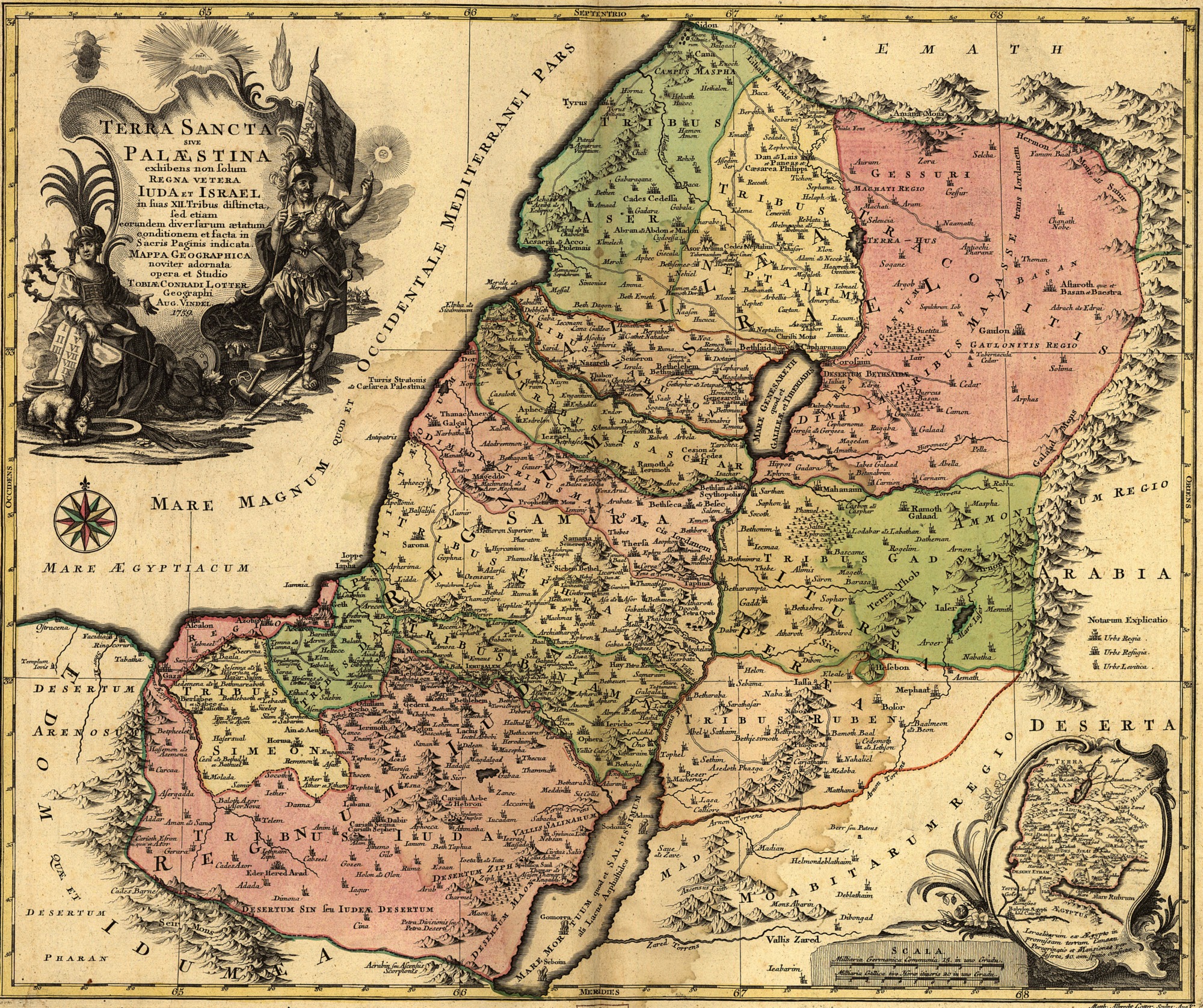
| Tobias Conrad Lotter: Latina: Terra Sancta sive Palæstina exhibens no ſolum Regna vetera Iuda et Israel in ſuas XII Tribus diſtincta, ſed etiam eorundem diverſarum ætatum conditionem et facta in Sacris Paginis indicata.
( |
|||||||||||||||||||||||
|---|---|---|---|---|---|---|---|---|---|---|---|---|---|---|---|---|---|---|---|---|---|---|---|
| Artist |
artist QS:P170,Q106511 |
||||||||||||||||||||||
| Sernav |
Latina: Terra Sancta sive Palæstina exhibens no ſolum Regna vetera Iuda et Israel in ſuas XII Tribus diſtincta, ſed etiam eorundem diverſarum ætatum conditionem et facta in Sacris Paginis indicata. |
||||||||||||||||||||||
| Danasîn |
English: English Translation: The Holy Land or Palestine showing not only the Old Kingdoms of Judea and Israel but also the 12 Tribes Distinctly, Confirming their Locations Diversely in their Ancient Condition and Doing So as the Holy Scriptures Indicate. |
||||||||||||||||||||||
| Dîrok |
1759 date QS:P571,+1759-00-00T00:00:00Z/9 |
||||||||||||||||||||||
| Medium | hand-colored | ||||||||||||||||||||||
| Dimensions |
Bilindahî: 47 cm; panî: 57 cm dimensions QS:P2048,47U174728 dimensions QS:P2049,57U174728 |
||||||||||||||||||||||
| Berhevok | Library of Congress Geography and Map Division Washington, D.C. 20540-4650 | ||||||||||||||||||||||
| Not | Scale [ca. 1:695,000] | ||||||||||||||||||||||
| Source/Photographer | Geography and Map Division, Library of Congress | ||||||||||||||||||||||
| Guhartoyên din |
 |
||||||||||||||||||||||
Lîsans
|
This is a faithful photographic reproduction of a two-dimensional, public domain work of art. The work of art itself is in the public domain for the following reason:
The official position taken by the Wikimedia Foundation is that "faithful reproductions of two-dimensional public domain works of art are public domain".
This photographic reproduction is therefore also considered to be in the public domain in the United States. In other jurisdictions, re-use of this content may be restricted; see Reuse of PD-Art photographs for details. | |||||
Captions
Add a one-line explanation of what this file represents
سرزمین مقدس یا فلسطین نه تنها پادشاهی های قدیمی یهودا و اسرائیل، بلکه 12 قبیله را به طور مشخص نشان می دهد، مکان های خود را به گونه ای متفاوت در شرایط باستانی خود تأیید می کنند و همانطور که کتاب مقدس نشان می دهد چنین می کنند.
Святая Земля или Палестина, на которой отчетливо изображены не только Древние царства Иудея и Израиль, но и 12-ть колен, что по-разному подтверждает их местоположение в их древнем состоянии и делает это так, как указано в Священном Писании.
Yalnızca Eski Yahudiye ve İsrail Krallıkları'nı değil, aynı zamanda 12 Kabile'yi de açıkça gösteren Kutsal Topraklar veya Filistin, konumlarını eski durumlarında çeşitli şekillerde doğruluyor ve bunu kutsal yazıların gösterdiği gibi yapıyor.
Items portrayed in this file
motîv Kurdish (Latin script) (transliterated)
media type îngilîzî
image/jpeg
checksum îngilîzî
9aec441e2a748bb1f14eca6e42dd7d08ce2e766b
data size îngilîzî
1.827.878 byte
1676 pixel
panî Kurdish (Latin script) (transliterated)
2000 pixel
Dîroka daneyê
Ji bo dîtina guhartoya wê demê bişkoka dîrokê bitikîne.
| Dîrok/Katjimêr | Wêneyê biçûk | Mezinahî | Bikarhêner | Şirove | |
|---|---|---|---|---|---|
| niha | 10:43, 12 îlon 2005 | | 2000 x 1676 (1,74 MB) | Humus sapiens~commonswiki | 1759 map: Terra Sancta sive Palæstina exhibens no folum Regna vetera Iuda et Israel in fuas XII Tribus diftincta... Source: Library of Congress historical maps Category:Historical maps of the Middle East Category:Israel |
Bikaranîna pelê
Ev rûpelên li jêr vê dosyeyê bi kar tînin:
Bikaranîna gerdûnî ya pelê
Ev wîkiyên di rêzê de vê pelê bi kar tînin:
- Bikaranîna di ace.wikipedia.org de
- Bikaranîna di af.wikipedia.org de
- Bikaranîna di anp.wikipedia.org de
- Bikaranîna di ar.wikipedia.org de
- Bikaranîna di arz.wikipedia.org de
- Bikaranîna di ast.wikipedia.org de
- Bikaranîna di az.wikipedia.org de
- Bikaranîna di ba.wikipedia.org de
- Bikaranîna di be.wikipedia.org de
- Bikaranîna di bg.wikipedia.org de
- Bikaranîna di bn.wikipedia.org de
- Bikaranîna di ca.wikipedia.org de
- Bikaranîna di crh.wikipedia.org de
- Bikaranîna di cs.wikipedia.org de
- Bikaranîna di cv.wikipedia.org de
- Bikaranîna di da.wikipedia.org de
- Bikaranîna di de.wikipedia.org de
- Bikaranîna di de.wikisource.org de
- Bikaranîna di diq.wikipedia.org de
- Bikaranîna di el.wikipedia.org de
- Bikaranîna di en.wikipedia.org de
- Bikaranîna di en.wikiversity.org de
- Bikaranîna di eo.wikipedia.org de
- Bikaranîna di es.wikipedia.org de
Zêdetir bikaranîna global a vê pelê bibîne.
Ji "https://ku.wikipedia.org/wiki/Wêne:1759_map_Holy_Land_and_12_Tribes.jpg" hatiye standin.