File:Kingdoms_of_the_Levant_Map_830.xcf
From Wikipedia, the free encyclopedia
Size of this PNG preview of this XCF file: 503 × 600 pîksel. Resolusyonên din: 201 × 240 pîksel | 402 × 480 pîksel | 644 × 768 pîksel | 858 × 1024 pîksel | 1955 × 2332 pîksel.
Dosyeya orjînal (1955 × 2332 pixel, mezinbûnê data: 941 KB, MIME-typ: image/x-xcf)
| Ev pel ji Wikimedia Commonsê ye. Agahdariya li ser rûpela danasîna pelê li jêr tê nîşandan. |
|
|
Danasîn
| DanasînKingdoms of the Levant Map 830.xcf |
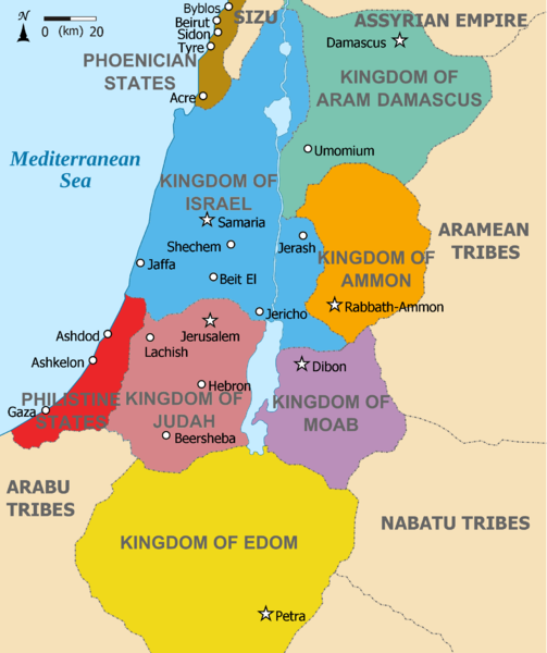
English: Map showing Kingdoms of the Levant c 830. The Kingdoms:
العربية: خريطة توضح ممالك بلاد الشام ج 830. الممالك:
فينيقيا - بني ارام دمشق - زبرجد آمون - البرتقالي موآب - بنفسجي ايدوم - الأصفر فلسطين - أحمر يهوذا - مارون تُظهر الخريطة المنطقة في القرن التاسع قبل الميلاد. |
| Dîrok | (UTC) |
| Çavkanî |
This file was derived from: |
| Xwedî |
|
| Guhartoyên din | Derivative works of this file: Kingdoms of the Levant Map 830.png |


| Ew wêneyekî guhertî ye, li ser wêneyê orjînal guhertin hatiye çêkirin û ev pêk hatiye. Guhertinên hatine çêkirin: Added colours for the two kingdoms.Tu dikarî li Kingdoms of Israel and Judah map 830.svg wêneyê orjînal bibînî. Guhertinên wêne ji aliyê Dlv999 ve hatine çêkirin.
|
Lîsans
Ev pel di bin lîsansa Creative Commons Attribution-Share Alike 3.0 Unported de lîsanskirî ye.
- Tu azad î:
- parve bike – ji bo kopîkirin, belavkirin û weşandina xebatê
- ji bo guhartin û adaptekirina naverokê – ji bo adaptekirina xebatê
- Di bin van mercan de:
- isnad – Divê tu isnadeke maqûl bikî, lînekek pêşkêş bikî ji bo lîsansê, û diyar bikî ku guhartin hatiye kirin an na. Tu dikarî vê yekê bi adilî bi cih bînî, lê ne bi awayê ku wekî lîsansor te an bikaranîna te pejirandibe.
- parvekirinê mîna hev – Ger tu materyalê biguherînî, bizivirînî formeke din, an ava bikî divê beşdariyên xwe di bin eynî lîsansê an lîsansa hevaheng de wekî ya eslî belav bikî.
Original upload log
This image is a derivative work of the following images:
- File:Kingdoms_around_Israel_830_map.svg licensed with Cc-by-sa-3.0, GFDL
- 2010-07-13T12:58:31Z Richardprins 720x859 (169373 Bytes) livened up the colors, converted med sea text to path
- 2010-07-13T11:26:40Z Richardprins 720x859 (141985 Bytes) {{Information |Description={{en|1=Map showing the ancient levant borders and ancient cities such as [[Urmomium]] and [[Jerash]]. The Kingdoms around Israel and Judah are colored. The map also shows the region in the 9th centu
- File:Kingdoms_of_Israel_and_Judah_map_830.svg licensed with Cc-by-sa-3.0, GFDL
- 2011-02-12T23:48:05Z Richardprins 720x859 (80190 Bytes) -
- 2010-07-13T11:29:47Z Richardprins 720x859 (80899 Bytes) Fixed Judah color
- 2010-07-13T10:51:49Z Richardprins 720x859 (80858 Bytes) Added colors for the two kingdoms and converted their text to path and arial
- 2010-07-12T23:53:35Z Richardprins 720x859 (63843 Bytes) Shrinked down the borders
- 2010-07-12T19:43:31Z Richardprins 720x859 (63800 Bytes) {{Information |Description={{en|1=Map showing the ancient levant borders and ancient cities such as [[Urmomium]] and [[Jerash]]. The map also shows the region in the 9th century BCE. Notice the coastal land of Philistia, from
Uploaded with derivativeFX
Captions
Add a one-line explanation of what this file represents
Items portrayed in this file
motîv Kurdish (Latin script) (transliterated)
rewşa mafê telîfê Kurdish (Latin script) (transliterated)
copyrighted îngilîzî
destûr Kurdish (Latin script) (transliterated)
dema avabûnê Kurdish (Latin script) (transliterated)
12 adar 2012
media type îngilîzî
image/x-xcf
Dîroka daneyê
Ji bo dîtina guhartoya wê demê bişkoka dîrokê bitikîne.
| Dîrok/Katjimêr | Wêneyê biçûk | Mezinahî | Bikarhêner | Şirove | |
|---|---|---|---|---|---|
| niha | 11:26, 12 adar 2012 |  | 1955 x 2332 (941 KB) | Dlv999 | == {{int:filedesc}} == {{Information |Description={{en|1=Map showing Kingdoms of the Levant c 830. The Kingdoms: * Phoenicia -Brown * Aram Damascus - Aquamarine * Amon - Orange * Moab - Purple * Edom - Yellow * Philistia - Red * Israel - Blue) *... |
Bikaranîna pelê
Rûpelekî ku ji vê dosyeyê bi kar tîne nîne.
Bikaranîna gerdûnî ya pelê
Ev wîkiyên di rêzê de vê pelê bi kar tînin:
- Bikaranîna di ar.wikipedia.org de
- Bikaranîna di en.wikipedia.org de
- Bikaranîna di hr.wikipedia.org de
- Bikaranîna di mg.wikipedia.org de
Ji "https://ku.wikipedia.org/wiki/Wêne:Kingdoms_of_the_Levant_Map_830.xcf" hatiye standin.