파일:Map_of_Hven_from_copper_etching_of_Blaeu_Atlas_1663.jpg
From Wikipedia, the free encyclopedia
원본 파일 (6,304 × 4,939 픽셀, 파일 크기: 19.49 MB, MIME 종류: image/jpeg)
| 설명Map of Hven from copper etching of Blaeu Atlas 1663.jpg |
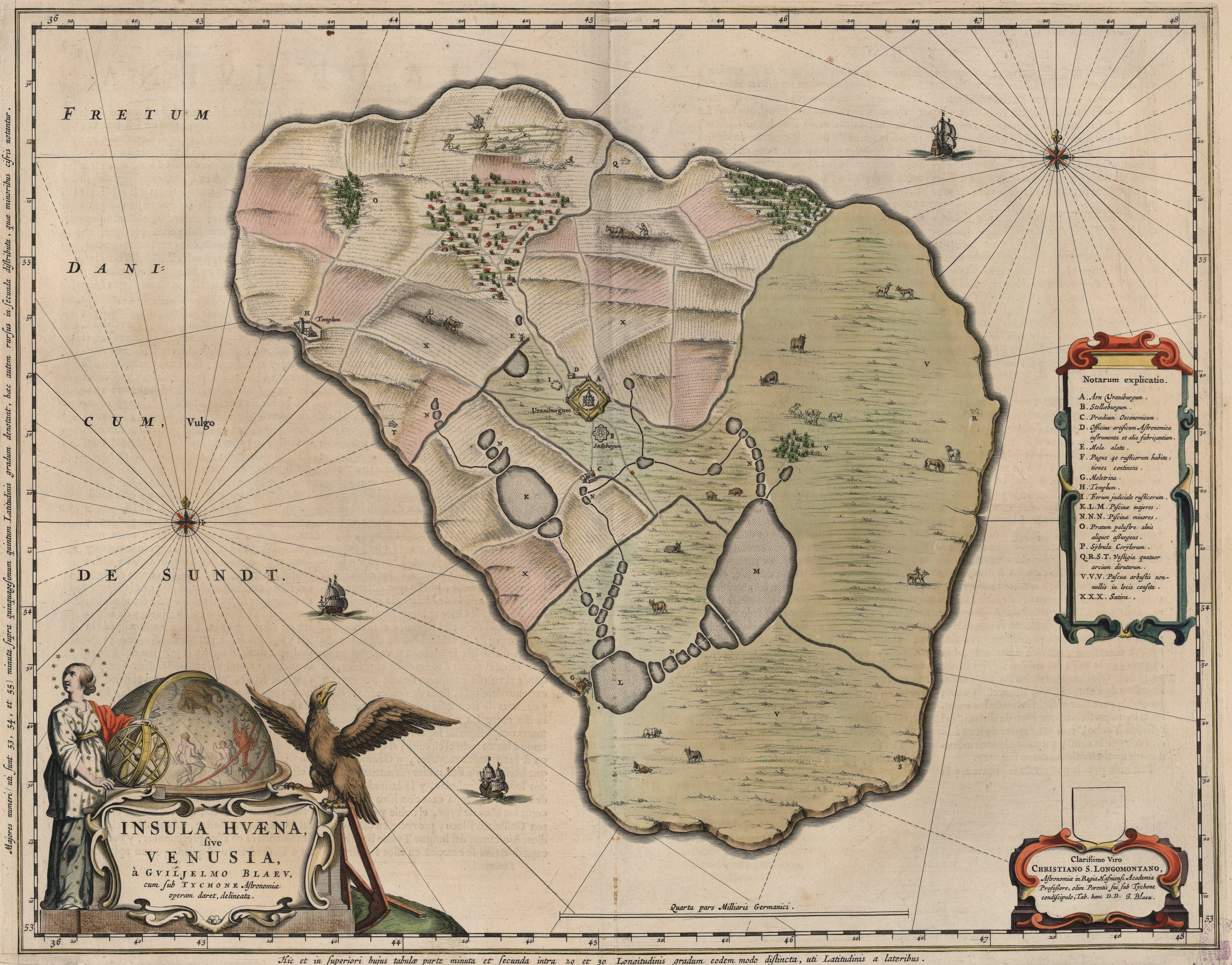
English: Map of the island of Hven from a copper etching of Willem Janszoon Blaeu's Blaeu Atlas 1663.
Willem made this map based on his experience as a student of Tycho Brahe between 1594 and 1596. On this map North is up, Denmark to the west and Scania, now part of Sweden, to the east. It shows the location of Uraniborg just above the centre, and below the linked set of ponds that Tycho had created to both collect water and power his papermill and other small industries on the island. Name of map : INSULAE HVAENA Map record source: Biblioteca Nacionale Espana (click on "View Digital object" to browse from the first page down to "GMG/189/177/mapa") (1664 is date of atlas on title page at "GMG/189/5/hg-ilustracionr") vorige upload: Tychobrahe.com
|
||||||||||||||||||||||||||
| 날짜 | |||||||||||||||||||||||||||
| 출처 | (There is no permanent link) Browse to [1], click "View Digital Object", scroll down and click on link "GMG/189/177/mapa", image should appear named "GMG189177mapa.jpeg" in right hand panel. | ||||||||||||||||||||||||||
| 저자 |
creator QS:P170,Q379677 |
||||||||||||||||||||||||||
.jpg)
| Public domainPublic domainfalsefalse |
|
이 작품은 미국, 그리고 저작권 보호 기간이 저작자 사후 100년, 또는 그 이하인 모든 국가에서 퍼블릭 도메인입니다. | |
| 이 저작물은 모든 저작인접권을 포함한 저작권법하의 규제로부터 자유로운 것으로 확인되었습니다. | |
https://creativecommons.org/publicdomain/mark/1.0/PDMCreative Commons Public Domain Mark 1.0falsefalse
| 주석 InfoField | 이 이미지에는 주석이 있습니다: 공용에서 주석을 보기 |


| 대상 위치 | 55° 54′ 25.09″ N, 12° 41′ 49.2″ E | 이 지역의 다른 사진을 보기: OpenStreetMap |
|---|
설명
이 파일에 묘사된 항목
다음을 묘사함
1663
55°54'28.001"N, 12°41'46.000"E
파일 역사
날짜/시간 링크를 클릭하면 해당 시간의 파일을 볼 수 있습니다.
| 날짜/시간 | 섬네일 | 크기 | 사용자 | 설명 | |
|---|---|---|---|---|---|
| 현재 | 2016년 8월 9일 (화) 10:06 | | 6,304 × 4,939 (19.49 MB) | Centpacrr | crp |
| 2013년 1월 4일 (금) 20:46 |  | 7,598 × 6,341 (5.28 MB) | Joop Rotte | ietwat hogere resolutie | |
| 2005년 12월 31일 (토) 03:18 |  | 750 × 601 (89 KB) | Fred J | :: '' Originally uploaded on English Wikipedia by en:User:Wikibob. Map of the island of Hven from a copper etching of Willem Janszoon Blaeu's Blaeu Atlas 1663. Willem made this map while a student of Tycho Brahe between 1594 and 1596. On th |
이 파일을 사용하는 문서
다음 문서 1개가 이 파일을 사용하고 있습니다:
이 파일을 사용하고 있는 모든 위키의 문서 목록
다음 위키에서 이 파일을 사용하고 있습니다:
- de.wikipedia.org에서 이 파일을 사용하고 있는 문서 목록
- en.wikipedia.org에서 이 파일을 사용하고 있는 문서 목록
- et.wikipedia.org에서 이 파일을 사용하고 있는 문서 목록
- fa.wikipedia.org에서 이 파일을 사용하고 있는 문서 목록
- fr.wikipedia.org에서 이 파일을 사용하고 있는 문서 목록
- ia.wikipedia.org에서 이 파일을 사용하고 있는 문서 목록
- ja.wikipedia.org에서 이 파일을 사용하고 있는 문서 목록
- la.wikipedia.org에서 이 파일을 사용하고 있는 문서 목록
- mk.wikipedia.org에서 이 파일을 사용하고 있는 문서 목록
- nl.wikipedia.org에서 이 파일을 사용하고 있는 문서 목록
- pl.wikipedia.org에서 이 파일을 사용하고 있는 문서 목록
- ru.wikipedia.org에서 이 파일을 사용하고 있는 문서 목록
- sv.wikipedia.org에서 이 파일을 사용하고 있는 문서 목록
- uk.wikipedia.org에서 이 파일을 사용하고 있는 문서 목록
- zh.wikipedia.org에서 이 파일을 사용하고 있는 문서 목록
메타데이터
이 파일에는 카메라나 스캐너가 파일을 만들거나 디지털화하는 데 사용하기 위해 기록한 부가 정보가 포함되어 있습니다.
프로그램에서 파일을 편집한 경우, 새로 저장한 파일에 일부 부가 정보가 빠질 수 있습니다.
| 너비 | 7,598 px |
|---|---|
| 높이 | 6,341 px |
| 픽셀당 비트 수 |
|
| 픽셀 배열 | RGB |
| 방향 | 일반 |
| 화소 수 | 3 |
| 수평 해상도 | 300 dpi |
| 수직 해상도 | 300 dpi |
| 사용한 소프트웨어 | Adobe Photoshop CS5 Macintosh |
| 파일이 바뀐 날짜와 시간 | 2016년 8월 8일 (월) 21:05 |
| Exif 버전 | 2.21 |
| 색 공간 | 조정되지 않음 |
| 날짜와 시간(디지털 데이터) | 2016년 8월 8일 (월) 17:04 |
| 메타데이터가 마지막으로 수정된 날짜 | 2016년 8월 8일 (월) 17:05 |
| 원본 문서의 고유 ID | xmp.did:FC7F117407206811AFFDF4BE1ACD6254 |