ಚಿತ್ರ:Canada_topo.jpg
From Wikipedia, the free encyclopedia
ಮೂಲ ಕಡತ (೧,೪೦೦ × ೧,೨೧೧ ಚಿತ್ರಬಿಂದು, ಫೈಲಿನ ಗಾತ್ರ: ೭೯೧ KB, MIME ಪ್ರಕಾರ: image/jpeg)
ಈ ಫೈಲು ವಿಕಿಮೀಡಿಯ ಕಾಮನ್ಸ್ನಲ್ಲಿ ಇರುವುದು. ಅಲ್ಲಿನ ವಿವರಣೆ ಪುಟವನ್ನೇ ಕೆಳಗೆ ತೋರಿಸಲಾಗಿದೆ. ಕಾಮನ್ಸ್ ಕೃತಿಸ್ವಾಮ್ಯತೆಯಿಂದ ಮುಕ್ತ ಫೈಲುಗಳ ಒಂದು ಆಗರ. ಅಲ್ಲಿ ನೀವೂ ಸಹಕರಿಸಬಹುದು. |
Hhhdndicidm
ಸಾರಾಂಶ
| ವಿವರCanada topo.jpg |
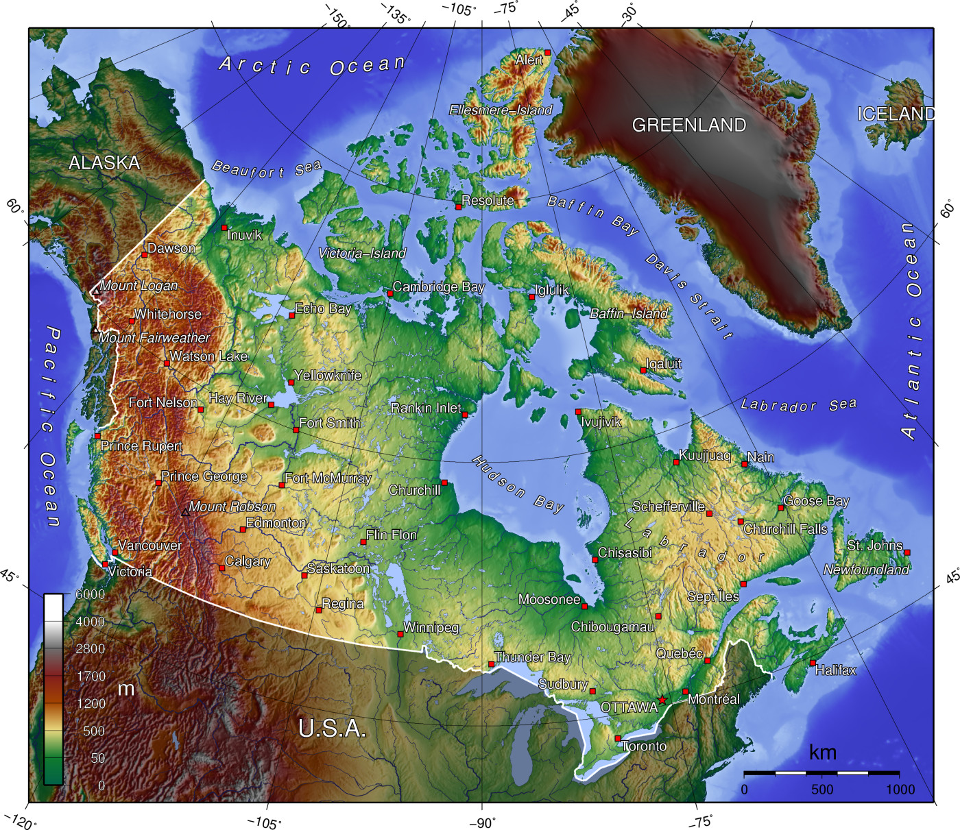
A topographic map of Canada, in polar projection (for 90° W), showing elevations shaded from green to brown (higher), with elevation-legend overlaid at lower left. Nearby countries are shaded darker (compare elevation shades at Canadian borders). The image is centered over longitude 90° W, with longitude meridians at 15-degree intervals apart, and latitude parallels also 15-degree. The boundaries are roughly from longitude 10°W to 177°W, and latitude 40°N to 84°N (above northern-most Alert, Canada 82°28′N, 62°30′W). |
| ದಿನಾಂಕ | 14-April-2006 (English Wikipedia image of 7-July-2005) |
| ಆಕರ | From English Wikipedia image of 7-July-2005, same name: en:Image:Canada topo.jpg (which now points here to Commons). |
| ಕರ್ತೃ | User:Anchjo (from en:Wikipedia User:Captain_Blood) |
| ಇತರೆ ಆವೃತ್ತಿಗಳು | Derivative works of this file: Dawson Route topo.jpg |
ಪರವಾನಗಿ
The map has been created with the Generic Mapping Tools: https://www.generic-mapping-tools.org/ using one or more of these public-domain datasets for the relief:
বাংলা ∙ English ∙ español ∙ français ∙ italiano ∙ 日本語 ∙ македонски ∙ sicilianu ∙ 中文(简体) ∙ 中文(繁體) ∙ +/− |

|
GNU ಉಚಿತ ಡಾಕ್ಯುಮೆಂಟೇಶನ್ ಪರವಾನಗಿ, ಆವೃತ್ತಿಯ ನಿಯಮಗಳ ಅಡಿಯಲ್ಲಿ ಈ ಡಾಕ್ಯುಮೆಂಟ್ ಅನ್ನು ನಕಲಿಸಲು, ವಿತರಿಸಲು ಮತ್ತು/ಅಥವಾ ಮಾರ್ಪಡಿಸಲು ಅನುಮತಿಯನ್ನು ನೀಡಲಾಗಿದೆ. 1.2 ಅಥವಾ ಯಾವುದೇ ನಂತರದ ಆವೃತ್ತಿಯನ್ನು ಉಚಿತ ಸಾಫ್ಟ್ವೇರ್ ಫೌಂಡೇಶನ್ ಪ್ರಕಟಿಸಿದೆ; ಯಾವುದೇ ಅಸ್ಥಿರ ವಿಭಾಗಗಳಿಲ್ಲದೆ, ಮುಖ ಪಠ್ಯಗಳಿಲ್ಲ ಮತ್ತು ಹಿಂದಿನ ಕವರ್ ಪಠ್ಯಗಳಿಲ್ಲ. ಪರವಾನಗಿಯ ಪ್ರತಿಯನ್ನು GNU ಉಚಿತ ಡಾಕ್ಯುಮೆಂಟೇಶನ್ ಪರವಾನಗಿ ಎಂಬ ವಿಭಾಗದಲ್ಲಿ ಸೇರಿಸಲಾಗಿದೆ.http://www.gnu.org/copyleft/fdl.htmlGFDLGNU Free Documentation Licensetruetrue |
| ಈ ಕಡತ ಕ್ರಿಯೇಟಿವ್ ಕಾಮನ್ಸ್ Attribution -Share Alike 3.0 Unported ಪರವಾನಗಿ ಹೊಂದಿದೆ. | ||
| ||
| This licensing tag was added to this file as part of the GFDL licensing update.http://creativecommons.org/licenses/by-sa/3.0/CC BY-SA 3.0Creative Commons Attribution-Share Alike 3.0truetrue |
Original upload log
- http://upload.wikimedia.org/wikipedia/en/d/d7/Canada topo.jpg[dead link] (14:36, 7 July 2005) . . User:Captain Blood (Captain Blood) (User talk:Captain Blood (Talk) ) . . 1400x1211 (810081 bytes) ({GMT})
Captions
Items portrayed in this file
depicts ಇಂಗ್ಲಿಷ್
copyright status ಇಂಗ್ಲಿಷ್
copyrighted ಇಂಗ್ಲಿಷ್
media type ಇಂಗ್ಲಿಷ್
image/jpeg
checksum ಇಂಗ್ಲಿಷ್
3ab064c6b03c834b1acf1aef60718ef80ba89f3b
data size ಇಂಗ್ಲಿಷ್
೮,೧೦,೦೮೧ byte
height ಇಂಗ್ಲಿಷ್
೧,೨೧೧ pixel
width ಇಂಗ್ಲಿಷ್
೧,೪೦೦ pixel
ಕಡತದ ಇತಿಹಾಸ
ದಿನ/ಕಾಲ ಒತ್ತಿದರೆ ಆ ಸಮಯದಲ್ಲಿ ಈ ಕಡತದ ವಸ್ತುಸ್ಥಿತಿ ತೋರುತ್ತದೆ.
| ದಿನ/ಕಾಲ | ಕಿರುನೋಟ | ಆಯಾಮಗಳು | ಬಳಕೆದಾರ | ಟಿಪ್ಪಣಿ | |
|---|---|---|---|---|---|
| ಪ್ರಸಕ್ತ | ೧೯:೫೨, ೧೪ ಏಪ್ರಿಲ್ ೨೦೦೬ | | ೧,೪೦೦ × ೧,೨೧೧ (೭೯೧ KB) | Anchjo | '''This file was transfered from [http://en.wikipedia.org en.wikipedia.org]. The original file description page is (was) here.''' == Original description at [http://en.wikipedia.org en] == {{GFDL-GMT}} [[:de:Bild:Kanada_topo |
ಕಡತ ಬಳಕೆ
ಈ ಕೆಳಗಿನ 3 ಪುಟಗಳು ಈ ಚಿತ್ರಕ್ಕೆ ಸಂಪರ್ಕ ಹೊಂದಿವೆ:
ಜಾಗತಿಕ ಕಡತ ಉಪಯೋಗ
ಈ ಕಡತವನ್ನು ಕೆಳಗಿನ ಬೇರೆ ವಿಕಿಗಳೂ ಉಪಯೋಗಿಸುತ್ತಿವೆ:
- an.wikipedia.org ಮೇಲೆ ಬಳಕೆ
- ar.wikipedia.org ಮೇಲೆ ಬಳಕೆ
- bg.wikipedia.org ಮೇಲೆ ಬಳಕೆ
- de.wikipedia.org ಮೇಲೆ ಬಳಕೆ
- en.wikipedia.org ಮೇಲೆ ಬಳಕೆ
- Talk:British Columbia
- Talk:Burgess Shale
- Geography of Canada
- Talk:Columbia River
- Talk:Newfoundland and Labrador
- Talk:Rocky Mountains
- Talk:Vinland
- Talk:Great Lakes
- Talk:Nunavut
- Talk:Muskeg
- Talk:Ellesmere Island
- Talk:St. Lawrence River
- Talk:Island of Montreal
- Talk:Provinces and territories of Canada
- Talk:Northern Canada
- Talk:Montreal
- Talk:Prince Edward Island
- Talk:Alberta
- Talk:Arctic Circle
- Talk:Emerald Park, Saskatchewan
- Talk:Cascade Range
- Talk:St. John's, Newfoundland and Labrador
- Talk:Citadel Hill (Fort George)
- Talk:List of communities in Quebec
- Talk:List of cities in Canada
- Talk:Nunavik
- Talk:Belcher Islands
- Talk:Carleton Place
- Talk:Beringia
- Talk:Quebec
- Talk:Plains of Abraham
- Talk:List of Hudson Bay rivers
- Talk:Yukon
- Talk:Inuvik
- Talk:Proposal for the Province of Toronto
- Talk:New Brunswick
- Talk:Surrey, British Columbia
- Talk:List of communities in Nova Scotia
- Talk:Greater Toronto Area
- Talk:Richmond County, Nova Scotia
- Talk:Lake Erie
- Talk:St. Marys River (Michigan–Ontario)
- Talk:100 Mile House
ಈ ಫೈಲ್ನ ಹೆಚ್ಚು ಜಾಗತಿಕ ಬಳಕೆಯನ್ನು ವೀಕ್ಷಿಸಿ.
ಮೇಲ್ದರ್ಜೆ ಮಾಹಿತಿ
ಈ ಫೈಲಿನಲ್ಲಿ ಹೆಚ್ಚಿನ ಮಾಹಿತಿ ಇದೆ. ಪ್ರಾಯಶಃ ಫೈಲನ್ನು ಸೃಷ್ಟಿಸಲು ಉಪಯೋಗಿಸಲಾದ ಡಿಜಿಟಲ್ ಕ್ಯಾಮೆರದಿಂದ ಅಥವ ಸ್ಕ್ಯಾನರ್ ಇಂದ ಈ ಮಾಹಿತಿ ಸೇರಿಸಲ್ಪಟ್ಟಿದೆ.
ಮೂಲಪ್ರತಿಯಿಂದ ಈ ಫೈಲು ಮಾರ್ಪಾಟಾಗಿದ್ದಲ್ಲಿ, ಈ ಮಾಹಿತಿ ಮಾರ್ಪಟ್ಟ ಫೈಲಿನ ವಿವರಗಳಿಗೆ ಸರಿಯಾಗಿ ಹೊಂದದೆ ಇರಬಹುದು.
| _error | ೦ |
|---|