ಚಿತ್ರ:Arabian_Sea_map.png
From Wikipedia, the free encyclopedia
ಈ ಮುನ್ನೋಟ ಗಾತ್ರ:೬೩೫ × ೬೦೦ ಪಿಕ್ಸೆಲ್ಗಳು. ಇತರ ರೆಸಲ್ಯೂಶನ್ಗಳು: ೨೫೪ × ೨೪೦ ಪಿಕ್ಸೆಲ್ಗಳು | ೫೦೮ × ೪೮೦ ಪಿಕ್ಸೆಲ್ಗಳು | ೭೯೭ × ೭೫೩ ಪಿಕ್ಸೆಲ್ಗಳು.
ಮೂಲ ಕಡತ (೭೯೭ × ೭೫೩ ಚಿತ್ರಬಿಂದು, ಫೈಲಿನ ಗಾತ್ರ: ೧೪೭ KB, MIME ಪ್ರಕಾರ: image/png)
ಈ ಫೈಲು ವಿಕಿಮೀಡಿಯ ಕಾಮನ್ಸ್ನಲ್ಲಿ ಇರುವುದು. ಅಲ್ಲಿನ ವಿವರಣೆ ಪುಟವನ್ನೇ ಕೆಳಗೆ ತೋರಿಸಲಾಗಿದೆ. ಕಾಮನ್ಸ್ ಕೃತಿಸ್ವಾಮ್ಯತೆಯಿಂದ ಮುಕ್ತ ಫೈಲುಗಳ ಒಂದು ಆಗರ. ಅಲ್ಲಿ ನೀವೂ ಸಹಕರಿಸಬಹುದು. |
ಸಾರಾಂಶ
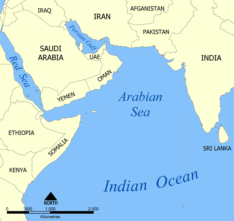
| ವಿವರArabian Sea map.png | A map showing the location of the Arabian Sea in the Indian Ocean. Created by NormanEinstein, July 19, 2005. |
| ದಿನಾಂಕ | |
| ಆಕರ | Self-published work by NormanEinstein |
| ಕರ್ತೃ | NormanEinstein, Ras67 |
| ಇತರೆ ಆವೃತ್ತಿಗಳು |
Derivative works of this file: |
ಪರವಾನಗಿ
I, the copyright holder of this work, hereby publish it under the following licenses:

|
GNU ಉಚಿತ ಡಾಕ್ಯುಮೆಂಟೇಶನ್ ಪರವಾನಗಿ, ಆವೃತ್ತಿಯ ನಿಯಮಗಳ ಅಡಿಯಲ್ಲಿ ಈ ಡಾಕ್ಯುಮೆಂಟ್ ಅನ್ನು ನಕಲಿಸಲು, ವಿತರಿಸಲು ಮತ್ತು/ಅಥವಾ ಮಾರ್ಪಡಿಸಲು ಅನುಮತಿಯನ್ನು ನೀಡಲಾಗಿದೆ. 1.2 ಅಥವಾ ಯಾವುದೇ ನಂತರದ ಆವೃತ್ತಿಯನ್ನು ಉಚಿತ ಸಾಫ್ಟ್ವೇರ್ ಫೌಂಡೇಶನ್ ಪ್ರಕಟಿಸಿದೆ; ಯಾವುದೇ ಅಸ್ಥಿರ ವಿಭಾಗಗಳಿಲ್ಲದೆ, ಮುಖ ಪಠ್ಯಗಳಿಲ್ಲ ಮತ್ತು ಹಿಂದಿನ ಕವರ್ ಪಠ್ಯಗಳಿಲ್ಲ. ಪರವಾನಗಿಯ ಪ್ರತಿಯನ್ನು GNU ಉಚಿತ ಡಾಕ್ಯುಮೆಂಟೇಶನ್ ಪರವಾನಗಿ ಎಂಬ ವಿಭಾಗದಲ್ಲಿ ಸೇರಿಸಲಾಗಿದೆ.http://www.gnu.org/copyleft/fdl.htmlGFDLGNU Free Documentation Licensetruetrue |
| ಈ ಕಡತ ಕ್ರಿಯೇಟಿವ್ ಕಾಮನ್ಸ್ Attribution -Share Alike 3.0 Unported ಪರವಾನಗಿ ಹೊಂದಿದೆ. | ||
| ||
| This licensing tag was added to this file as part of the GFDL licensing update.http://creativecommons.org/licenses/by-sa/3.0/CC BY-SA 3.0Creative Commons Attribution-Share Alike 3.0truetrue |
ನಿಮ್ಮಿಚ್ಛೆಯ ಪರವಾನಗಿಯನ್ನು ನೀವು ಆರಿಸಿಕೊಳ್ಳಬಹುದು.
Captions
Add a one-line explanation of what this file represents
Items portrayed in this file
depicts ಇಂಗ್ಲಿಷ್
copyright status ಇಂಗ್ಲಿಷ್
copyrighted ಇಂಗ್ಲಿಷ್
2005
media type ಇಂಗ್ಲಿಷ್
image/png
checksum ಇಂಗ್ಲಿಷ್
11d2e7e596b8bb1253ae1ba65e7311915c961a6e
data size ಇಂಗ್ಲಿಷ್
೧,೫೦,೬೦೭ byte
height ಇಂಗ್ಲಿಷ್
೭೫೩ pixel
width ಇಂಗ್ಲಿಷ್
೭೯೭ pixel
ಕಡತದ ಇತಿಹಾಸ
ದಿನ/ಕಾಲ ಒತ್ತಿದರೆ ಆ ಸಮಯದಲ್ಲಿ ಈ ಕಡತದ ವಸ್ತುಸ್ಥಿತಿ ತೋರುತ್ತದೆ.
| ದಿನ/ಕಾಲ | ಕಿರುನೋಟ | ಆಯಾಮಗಳು | ಬಳಕೆದಾರ | ಟಿಪ್ಪಣಿ | |
|---|---|---|---|---|---|
| ಪ್ರಸಕ್ತ | ೧೭:೨೪, ೧೩ ಜುಲೈ ೨೦೨೦ | | ೭೯೭ × ೭೫೩ (೧೪೭ KB) | Kzl55 | Restored longstanding version |
| ೧೯:೪೩, ೨೧ ಮಾರ್ಚ್ ೨೦೨೦ |  | ೬೩೫ × ೬೦೦ (೧೫೫ KB) | Noseisnostriledd | ctl | |
| ೦೫:೧೨, ೨೦ ಮಾರ್ಚ್ ೨೦೨೦ |  | ೬೩೫ × ೬೦೦ (೧೫೫ KB) | Noseisnostriledd | regional sea | |
| ೦೧:೨೮, ೨೯ ಡಿಸೆಂಬರ್ ೨೦೧೯ |  | ೭೯೭ × ೭೫೩ (೨೦೦ KB) | Noseisnostriledd | Add detail | |
| ೧೮:೫೦, ೧೪ ಏಪ್ರಿಲ್ ೨೦೧೧ |  | ೭೯೭ × ೭೫೩ (೧೪೭ KB) | Ras67 | cropped and squeezed | |
| ೨೦:೦೦, ೧೯ ಜುಲೈ ೨೦೦೫ |  | ೮೦೦ × ೭೫೭ (೨೨೩ KB) | NormanEinstein | A map showing the location of the Arabian Sea in the Indian Ocean. Created by NormanEinstein, Jully 19, 2005. {{GFDL-self}} Category:Maps of seas | |
| ೨೦:೦೦, ೧೯ ಜುಲೈ ೨೦೦೫ |  | ೮೦೦ × ೭೫೭ (೨೨೩ KB) | NormanEinstein | A map showing the location of the Arabian Sea in the Indian Ocean. Created by NormanEinstein, Jully 19, 2005. {{GFDL-self}} Category:Maps of seas |
ಕಡತ ಬಳಕೆ
ಈ ಕೆಳಗಿನ ಪುಟವು ಈ ಚಿತ್ರಕ್ಕೆ ಸಂಪರ್ಕ ಹೊಂದಿದೆ:
ಜಾಗತಿಕ ಕಡತ ಉಪಯೋಗ
ಈ ಕಡತವನ್ನು ಕೆಳಗಿನ ಬೇರೆ ವಿಕಿಗಳೂ ಉಪಯೋಗಿಸುತ್ತಿವೆ:
- af.wikipedia.org ಮೇಲೆ ಬಳಕೆ
- am.wikipedia.org ಮೇಲೆ ಬಳಕೆ
- ar.wikipedia.org ಮೇಲೆ ಬಳಕೆ
- ast.wikipedia.org ಮೇಲೆ ಬಳಕೆ
- as.wikipedia.org ಮೇಲೆ ಬಳಕೆ
- az.wikipedia.org ಮೇಲೆ ಬಳಕೆ
- az.wiktionary.org ಮೇಲೆ ಬಳಕೆ
- be-tarask.wikipedia.org ಮೇಲೆ ಬಳಕೆ
- bg.wikipedia.org ಮೇಲೆ ಬಳಕೆ
- bh.wikipedia.org ಮೇಲೆ ಬಳಕೆ
- bs.wikipedia.org ಮೇಲೆ ಬಳಕೆ
- bxr.wikipedia.org ಮೇಲೆ ಬಳಕೆ
- ckb.wikipedia.org ಮೇಲೆ ಬಳಕೆ
- cs.wikipedia.org ಮೇಲೆ ಬಳಕೆ
- cv.wikipedia.org ಮೇಲೆ ಬಳಕೆ
- cy.wikipedia.org ಮೇಲೆ ಬಳಕೆ
- da.wikipedia.org ಮೇಲೆ ಬಳಕೆ
- de.wikipedia.org ಮೇಲೆ ಬಳಕೆ
- diq.wikipedia.org ಮೇಲೆ ಬಳಕೆ
- dv.wikipedia.org ಮೇಲೆ ಬಳಕೆ
- en.wikipedia.org ಮೇಲೆ ಬಳಕೆ
- eo.wikipedia.org ಮೇಲೆ ಬಳಕೆ
- es.wikipedia.org ಮೇಲೆ ಬಳಕೆ
- eu.wikipedia.org ಮೇಲೆ ಬಳಕೆ
- fa.wikipedia.org ಮೇಲೆ ಬಳಕೆ
ಈ ಫೈಲ್ನ ಹೆಚ್ಚು ಜಾಗತಿಕ ಬಳಕೆಯನ್ನು ವೀಕ್ಷಿಸಿ.
"https://kn.wikipedia.org/wiki/ಚಿತ್ರ:Arabian_Sea_map.png" ಇಂದ ಪಡೆಯಲ್ಪಟ್ಟಿದೆ