File:South_Korea_location_map_topography_with_taebaek_and_sobaek_mountains_marked.jpg
From Wikipedia, the free encyclopedia
ទំហំរបស់ការមើលមុននេះ: ៦៣៥ × ៥៩៩ ភីកសែ។ ភាពម៉ត់ផ្សេងទៀត៖ ២៥៤ × ២៤០ ភីកសែ | ៥០៩ × ៤៨០ ភីកសែ | ៨១៤ × ៧៦៨ ភីកសែ | ១០៨៥ × ១០២៤ ភីកសែ | ១៧៧២ × ១៦៧២ ភីកសែ។
រូបភាពដើម (១៧៧២ × ១៦៧២ ភីកសែល ទំហំឯកសារ៖ ៥៥៣គីឡូបៃ ប្រភេទ MIME៖ image/jpeg)
ឯកសារនេះមានប្រភពមកពី Wikimedia Commons និងអាចត្រូវបានប្រើដោយគម្រោងដទៃទៀត។ ការពណ៌នានៅលើទំព័រពណ៌នាអំពីវា មានបង្ហាញខាងក្រោមនេះ។
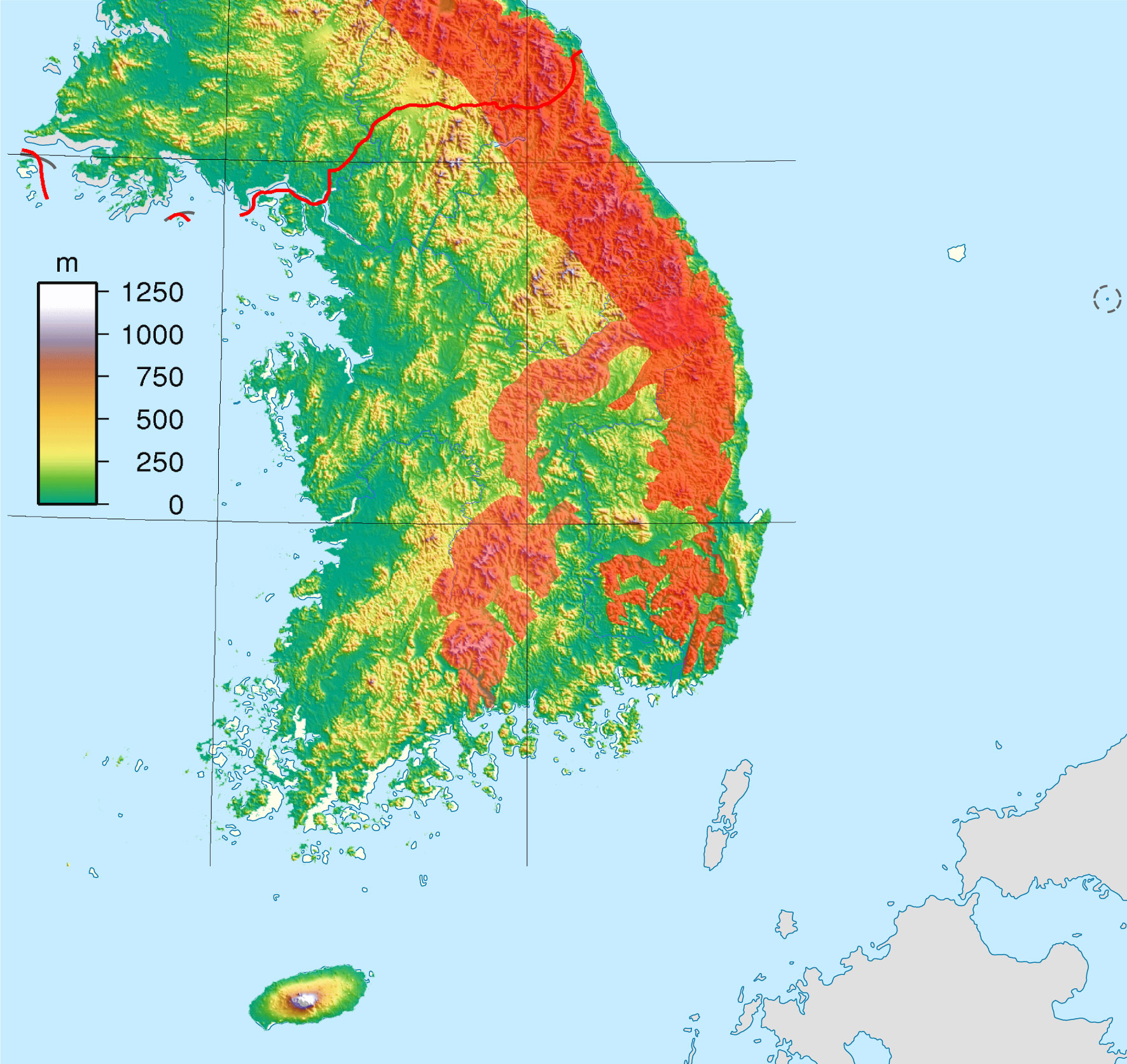
| ការពិពណ៌នាSouth Korea location map topography with taebaek and sobaek mountains marked.jpg | Topography map version designed to be used as an alternative map to South Korea location map.svg with the Taebaek and Sobaek Mountains regions marked in red |
| កាលបរិច្ឆេទ | (UTC) |
| ប្រភព | |
| អ្នកនិពន្ធ |
|
| This is a retouched picture, which means that it has been digitally altered from its original version. The original can be viewed here: South Korea Topography.png.
|
ឯកសារនេះជាប់អាជ្ញាបណ្ឌCreative Commons Attribution-Share Alike 3.0 Unported។
- អ្នកមានសិទ្ធិ៖
- ចែកចាយ – ថតចំលងនិងចែកចាយស្នាដៃនេះ
- កែច្នៃ – កែច្នៃយកទៅប្រើ
- ក្រោមលក្ខខណ្ឌដូចតទៅនេះ៖
- ភាពជាម្ចាស់កម្មសិទ្ធ – You must give appropriate credit, provide a link to the license, and indicate if changes were made. You may do so in any reasonable manner, but not in any way that suggests the licensor endorses you or your use.
- share alike – If you remix, transform, or build upon the material, you must distribute your contributions under the same or compatible license as the original.
Original upload log
This image is a derivative work of the following images:
- File:South_Korea_location_map.svg licensed with Cc-by-sa-3.0, GFDL
- 2010-10-24T17:48:10Z NordNordWest 1772x1672 (386497 Bytes) upd
- 2010-10-02T20:05:03Z NordNordWest 1559x1672 (357245 Bytes) upd
- 2008-08-26T18:57:44Z NordNordWest 1559x1673 (513639 Bytes) {{Information |Description= {{de|Positionskarte von [[:de:Südkorea|Südkorea]]}} Quadratische Plattkarte, N-S-Streckung 120 %. Geographische Begrenzung der Karte: * N: 38.9° N * S: 33.0° N * W: 124.5° O * O: 131.1° O {{e
- File:South_Korea_Topography.png licensed with Cc-by-sa-3.0,2.5,2.0,1.0, GFDL
- 2007-09-01T17:43:59Z Sadalmelik 1705x1979 (2489211 Bytes) {{Information |Description=Topographic map of South Korea. Created wth GMT from SRTM data. |Source=self-made |Date=Sep 1, 2007 |Author= [[User:Sadalmelik|Sadalmelik]] }} [[Category:Topographi
Uploaded with derivativeFX
Captions
Add a one-line explanation of what this file represents
Items portrayed in this file
depicts អង់គ្លេស
copyright status អង់គ្លេស
copyrighted អង់គ្លេស
copyright license អង់គ្លេស
inception អង់គ្លេស
០៧ ខែវិច្ឆិកា 2010
ប្រវត្តិឯកសារ
ចុចលើម៉ោងនិងកាលបរិច្ឆេទដើម្បីមើលឯកសារដែលបានផ្ទុកឡើងនៅពេលនោះ។
| ម៉ោងនិងកាលបរិច្ឆេទ | កូនរូបភាព | វិមាត្រ | អ្នកប្រើប្រាស់ | យោបល់ | |
|---|---|---|---|---|---|
| បច្ចុប្បន្ន | ម៉ោង០៤:៥៧ ថ្ងៃអាទិត្យ ទី០៧ ខែវិច្ឆិកា ឆ្នាំ២០១០ | | ១៧៧២ × ១៦៧២ (៥៥៣គីឡូបៃ) | 배우는사람 | {{Information |Description=Topography map version designed to be used as an alternative map to South Korea location map.svg with the Taebaek and Sobaek Mountains regio |
បម្រើបម្រាស់ឯកសារ
គ្មានទំព័រណាមួយដែលប្រើប្រាស់ឯកសារនេះទេ។
បម្រើបម្រាស់ឯកសារជាសាកល
វីគីដទៃទៀតដូចខាងក្រោមនេះប្រើប្រាស់ឯកសារនេះ៖
- ការប្រើប្រាស់នៅក្នុង ko.wikipedia.org
- ការប្រើប្រាស់នៅក្នុង no.wikipedia.org
ទិន្នន័យមេតា
ឯកសារនេះមានព័ត៌មានបន្ថែមដែលទំនងជាបានបន្ថែមពី ឧបករណ៍ថតរូបឌីជីថល ឬ ម៉ាស៊ីនស្កេន ដែលត្រូវបានប្រើប្រាស់ដើម្បីបង្កើត ឬ ធ្វើវាជាឌីជីថល។ បើសិនឯកសារបានត្រូវកែប្រែពី ស្ថានភាពដើម នោះសេចក្តីលំអិតខ្លះអាចនឹងមិនអាចឆ្លុះបញ្ចាំងពេញលេញទៅឯកសារដែលបានកែប្រែទេ។
| _error | ០ |
|---|