File:Africa_topography_map.png
From Wikipedia, the free encyclopedia
ទំហំរបស់ការមើលមុននេះ: ៦០៥ × ៦០០ ភីកសែ។ ភាពម៉ត់ផ្សេងទៀត៖ ២៤២ × ២៤០ ភីកសែ | ៤៨៤ × ៤៨០ ភីកសែ | ៧៧៥ × ៧៦៨ ភីកសែ | ១០៣៣ × ១០២៤ ភីកសែ | ២០៦៧ × ២០៤៨ ភីកសែ | ២៦៦៣ × ២៦៣៩ ភីកសែ។
រូបភាពដើម (២៦៦៣ × ២៦៣៩ ភីកសែល ទំហំឯកសារ៖ ១.៦៦មេកាបៃ ប្រភេទ MIME៖ image/png)
ឯកសារនេះមានប្រភពមកពី Wikimedia Commons និងអាចត្រូវបានប្រើដោយគម្រោងដទៃទៀត។ ការពណ៌នានៅលើទំព័រពណ៌នាអំពីវា មានបង្ហាញខាងក្រោមនេះ។
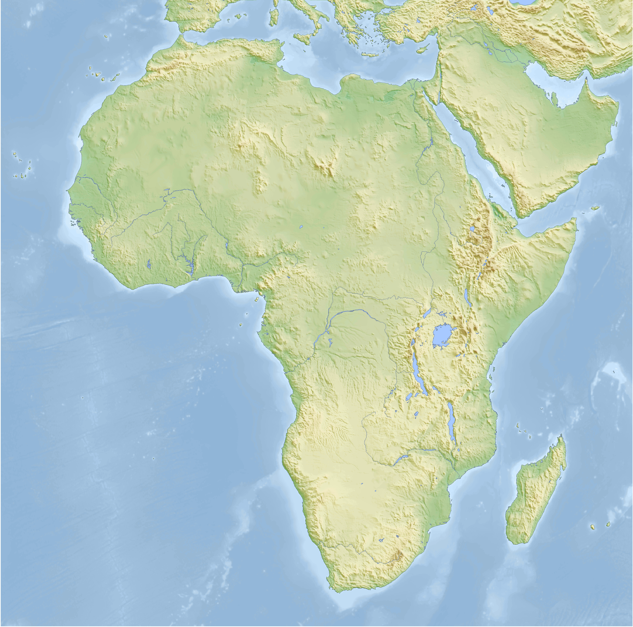
| ការពិពណ៌នាAfrica topography map.png | Topographic map of Africa, Cassini cylindrical projection |
| កាលបរិច្ឆេទ | |
| ប្រភព |
self-made, using GMT For the code see de:Benutzer:Lilleskut/Afrikakarte. |
| អ្នកនិពន្ធ | Bamse |
| ទំរង់ផ្សេងទៀត |
Derivative works of this file: Menelik II conquests map.svg with borders |
The map has been created with the Generic Mapping Tools: https://www.generic-mapping-tools.org/ using one or more of these public-domain datasets for the relief:
বাংলা ∙ English ∙ español ∙ français ∙ italiano ∙ 日本語 ∙ македонски ∙ sicilianu ∙ 中文(简体) ∙ 中文(繁體) ∙ +/− |

|
រូបភាពនៃទំព័រនេះជាកម្មសិទ្ធិរបស់GNU Free Documentation License។ Version 1.2 ឬក៏ខ្ពស់ជាងនេះត្រូវបានឧបត្ថមគាំទ្រដោយ មូលនិធិសូហ្វវែរដោយឥតគិតថ្លៃ (Free Software Foundation) ដែលមិនមានផ្នែកណាមួយរបស់ប្រភពដើមរួមទាំងអក្សរនៅលើគំរបមុខនិងខ្នង ត្រូវបានផ្លាស់ប្តូរទេ។ ចំពោះផ្នែកដែលមិនអាចផ្លាស់ប្តូរបាន សូមមើលGNU Free Documentation License។http://www.gnu.org/copyleft/fdl.htmlGFDLGNU Free Documentation Licensetruetrue |
| ឯកសារនេះជាប់អាជ្ញាបណ្ឌCreative Commons Attribution-Share Alike 3.0 Unported។ | ||
| ||
| This licensing tag was added to this file as part of the GFDL licensing update.http://creativecommons.org/licenses/by-sa/3.0/CC BY-SA 3.0Creative Commons Attribution-Share Alike 3.0truetrue |

|
This map has been made or improved in the German Kartenwerkstatt (Map Lab). You can propose maps to improve as well.
azərbaycanca ∙ čeština ∙ Deutsch ∙ Deutsch (Sie-Form) ∙ English ∙ español ∙ français ∙ italiano ∙ latviešu ∙ magyar ∙ Nederlands ∙ Plattdüütsch ∙ polski ∙ português ∙ română ∙ sicilianu ∙ slovenščina ∙ suomi ∙ македонски ∙ русский ∙ ქართული ∙ հայերեն ∙ বাংলা ∙ ไทย ∙ +/−
|
Captions
Add a one-line explanation of what this file represents
Items portrayed in this file
depicts អង់គ្លេស
creator អង់គ្លេស
some value
copyright status អង់គ្លេស
copyrighted អង់គ្លេស
inception អង់គ្លេស
១៩ ខែធ្នូ 2007
media type អង់គ្លេស
image/png
checksum អង់គ្លេស
b8715a1a86eb212b286ed6119a8e1fca7aca74ca
data size អង់គ្លេស
១៧៤១៤៥៨ byte
height អង់គ្លេស
២៦៣៩ pixel
width អង់គ្លេស
២៦៦៣ pixel
ប្រវត្តិឯកសារ
ចុចលើម៉ោងនិងកាលបរិច្ឆេទដើម្បីមើលឯកសារដែលបានផ្ទុកឡើងនៅពេលនោះ។
| ម៉ោងនិងកាលបរិច្ឆេទ | កូនរូបភាព | វិមាត្រ | អ្នកប្រើប្រាស់ | យោបល់ | |
|---|---|---|---|---|---|
| បច្ចុប្បន្ន | ម៉ោង០៧:៤១ ថ្ងៃអង្គារ ទី១២ ខែកុម្ភៈ ឆ្នាំ២០០៨ | | ២៦៦៣ × ២៦៣៩ (១.៦៦មេកាបៃ) | Bamse | |
| ម៉ោង០៣:៥១ ថ្ងៃអង្គារ ទី២៩ ខែមករា ឆ្នាំ២០០៨ |  | ២៦៦៣ × ២៦៣៩ (១.៦៦មេកាបៃ) | Bamse | ||
| ម៉ោង០៩:០៣ ថ្ងៃអង្គារ ទី២២ ខែមករា ឆ្នាំ២០០៨ |  | ២៦៦៣ × ២៦៣៩ (១.៦៧មេកាបៃ) | Bamse | ||
| ម៉ោង០៥:៥២ ថ្ងៃសុក្រ ទី១១ ខែមករា ឆ្នាំ២០០៨ |  | ២៧២៨ × ២៧០៣ (១.៧មេកាបៃ) | Bamse | ||
| ម៉ោង០៥:២៣ ថ្ងៃសុក្រ ទី១១ ខែមករា ឆ្នាំ២០០៨ |  | ២៧២៨ × ២៧០៣ (១.៦៩មេកាបៃ) | Bamse | ||
| ម៉ោង០៤:២៦ ថ្ងៃពុធ ទី១៩ ខែធ្នូ ឆ្នាំ២០០៧ |  | ២៥០០ × ២៤៧៩ (២.៤៥មេកាបៃ) | Bamse | {{Information |Description=topographic map of Africa |Source=self-made |Date=19-12-2007 |Author= Bamse |Permission= |other_versions= }} {{GFDL-GMT}} |
បម្រើបម្រាស់ឯកសារ
គ្មានទំព័រណាមួយដែលប្រើប្រាស់ឯកសារនេះទេ។
បម្រើបម្រាស់ឯកសារជាសាកល
វីគីដទៃទៀតដូចខាងក្រោមនេះប្រើប្រាស់ឯកសារនេះ៖
- ការប្រើប្រាស់នៅក្នុង azb.wikipedia.org
- ការប្រើប្រាស់នៅក្នុង de.wikipedia.org
- ការប្រើប្រាស់នៅក្នុង de.wikiversity.org
- ការប្រើប្រាស់នៅក្នុង pt.wikinews.org