File:Colonisation_1885.png
From Wikipedia, the free encyclopedia
Түпнұсқа файл (1200 × 526 пиксел, файл өлшемі: 206 КБ, MIME түрі: image/png)
| Бұл файл Wikimedia Commons? жобасынан, сондықтан басқа жобаларда да қолдануы мүмкін. Commons ашық лицензиялы медиа файл қоры. Сіз жобаға көмектесе аласыз. |
Ортаққордан қарау |
| References for this description (or part of this) or for the depiction in the file are not provided. |
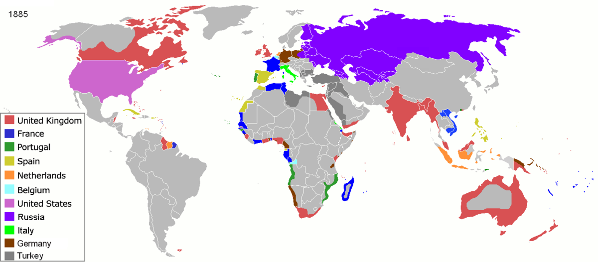
| СипаттамасыColonisation 1885.png |
Map of major world powers by year, derived from public domain animated map on wikipedia.
As the orriginal licence of the animation was Public Domain, this image which has been derived from it is too:
|
|||||||||||||||||||
| Күні | ||||||||||||||||||||
| Көзі | public domain animated map by ArdadN here | |||||||||||||||||||
| Авторы | ArdadN | |||||||||||||||||||
.jpg)
._LOC_2001620596.jpg)

|
This historical map image could be re-created using vector graphics as an SVG file. This has several advantages; see Commons:Media for cleanup for more information. If an SVG form of this image is available, please upload it and afterwards replace this template with
{{vector version available|new image name}}.
It is recommended to name the SVG file “Colonisation 1885.svg”—then the template Vector version available (or Vva) does not need the new image name parameter. |
Captions
Items portrayed in this file
суреттелген нәрсе
copyright status ағылшын тілі
copyright license ағылшын тілі
inception ағылшын тілі
22 наурыз, 2007
media type ағылшын тілі
image/png
checksum ағылшын тілі
831fd10c262a996a3291205f48ebb3278f0cca4d
data size ағылшын тілі
210 626 Байт
526 нүкте
width ағылшын тілі
1200 нүкте
Файл тарихы
Файл сол кезде қалай көрінгенін көру үшін күн/уақыт дегенге басыңыз.
| Күн/Уақыт | Нобай | Өлшемдер | Қатысушы | Пікір | |
|---|---|---|---|---|---|
| қазіргі | 14:05, 2021 ж. қарашаның 8 | | 1200 × 526 (206 КБ) | Randomastwritter | jubaland |
| 14:52, 2020 ж. сәуірдің 5 |  | 1200 × 526 (206 КБ) | Ориенталист | South Sakhalin was part of Russia in 1885 | |
| 16:17, 2015 ж. мамырдың 2 |  | 1425 × 625 (49 КБ) | Chrischerf | German Empire and colonies in 1885; Sudan under control of the Mahdi | |
| 07:57, 2014 ж. тамыздың 3 |  | 1425 × 625 (54 КБ) | Alvin Lee | correcting the boundaries of Russia and China | |
| 18:54, 2013 ж. қарашаның 3 |  | 1425 × 625 (78 КБ) | McZusatz | Reverted to version as of 00:22, 24 January 2011 [corrupt file?] | |
| 20:24, 2012 ж. қарашаның 3 |  | 1425 × 625 (67 КБ) | Franco310397 | Spanish presence in Micronesia (Oceania) included in the Captaincy General of the Philippines. In the Caroline Islands and the Mariana Islands. | |
| 05:22, 2011 ж. қаңтардың 24 |  | 1425 × 625 (78 КБ) | Micsha~commonswiki | Reverted to version as of 02:17, 3 May 2010 | |
| 05:22, 2011 ж. қаңтардың 24 |  | 506 × 326 (85 КБ) | Micsha~commonswiki | Only Africa; includes map key | |
| 07:17, 2010 ж. мамырдың 3 |  | 1425 × 625 (78 КБ) | Kieran4 | slight edit | |
| 07:14, 2010 ж. мамырдың 3 |  | 1425 × 625 (78 КБ) | Kieran4 | Correct Dutch East INdies |
Файл қолданылуы
Бұл файлға еш бет сілтемейді.
Глобалды файл қолданылуы
Бұл файл келесі басқа уикилерде қолданылады:
- am.wikipedia.org жобасында қолданылуы
- de.wikipedia.org жобасында қолданылуы
- en.wikipedia.org жобасында қолданылуы
- es.wikipedia.org жобасында қолданылуы
- fr.wikipedia.org жобасында қолданылуы
- he.wikipedia.org жобасында қолданылуы
- oc.wikipedia.org жобасында қолданылуы
- sk.wikipedia.org жобасында қолданылуы
Метадеректер
Бұл файлда цифрлық камера немесе оны цифрландыруға қолданылған сканер қосқан болуы мүмкін қосымша ақпарат бар.
Файл бастапқы күйінен өзгертілген болса, кейбір ақпарат өзгертілген файлды дұрыс сипаттамауы мүмкін.
| PNG файл пікірі | |
|---|---|
| Дерелей ажыратылымдығы | 47,24 dpc |
| Тірелей ажыратылымдығы | 47,24 dpc |
| Қолданылған бағдарламалық жасақтама |