File:Mauritius_Island_topographic_map-fr.jpg
From Wikipedia, the free encyclopedia
Tiddi n azaraskan agi : 502 × 599 iferdisen n tugna. Tibuda nniḍen : 201 × 240 iferdisen n tugna | 402 × 480 iferdisen n tugna | 643 × 768 iferdisen n tugna | 858 × 1 024 iferdisen n tugna | 1 810 × 2 160 iferdisen n tugna.
Afaylu aneṣli (1 810 × 2 160 pixel, tiddi n ufaylu: 942 KB/KO, anaw n MIME: image/jpeg)
Afaylu agi yusad seg : Wikimedia Commons. Ahat yeseqdec deg isenfaṛen nniḍen. Aglam-is ɣef asebter n aglam ye beqqeḍ ddaw-agi.
Agzul
| Lieu de la prise de vue | 20° 15′ 00″ S, 57° 35′ 00″ E | Voir cet endroit et d’autres images sur : OpenStreetMap |
|---|
| AglamMauritius Island topographic map-fr.jpg |
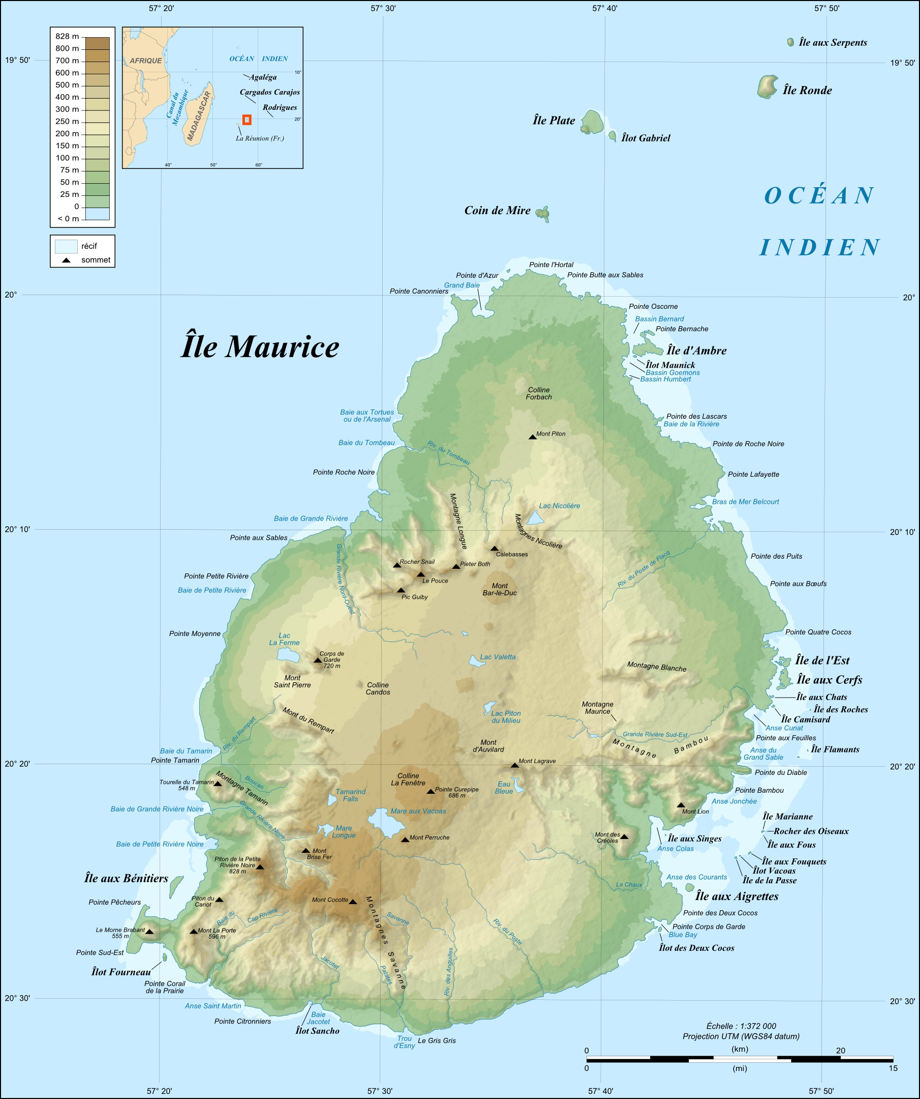
English: Topographic map in French of Mauritius Island.
|
||
| Azemz | |||
| Aɣbalu |
Own work ;
|
||
| Ameskar | Eric Gaba (Sting - fr:Sting) | ||
| Tasiregt (Tulsa n useqdec n ufaylu-agi) |
|
||
| Autres versions |
[beddel]
|


Cette carte a été améliorée ou créée par les Wikigraphistes de l'Atelier graphique (fr). Vous pouvez également y proposer des images, blasons, drapeaux ou cartes à améliorer, créer, ou traduire. |
Turagt
Moi, en tant que détenteur des droits d’auteur sur cette œuvre, je la publie sous les licences suivantes :

|
Ɣuṛ-k tasiregt akken ad tneɣleḍ, ad tzuzreḍ neɣ ad tesnifleḍ isemli-agi akken yella di tewtilin n GNU Free Documentation License lqem 1.2 neq yal lqem amaynut i d-yeffɣen sɣuṛ Free Software Foundation, s war abeddel di tgezmiyin, s war aḍris deg usebter amenzu n tdulineɣ s war aḍris deg usebter aneggaru n tduli. Amedya n turagt yedda deg tgezmi ittusemman GNU Free Documentation License.http://www.gnu.org/copyleft/fdl.htmlGFDLGNU Free Documentation Licensetruetrue |
This file is licensed under the Creative Commons Attribution-Share Alike Attribution-Share Alike 4.0 International, 3.0 Unported, 2.5 Generic, 2.0 Generic and 1.0 Generic license.
- Ɣuṛ-k tilelli:
- i beṭṭu – akken ad tneɣleḍ, ad tzuzreḍ neɣ ad tebḍuḍ amahil-agi
- i uṣeggem – i uṣeggem n umahil
- Ddaw n tiwtilin-agi:
- bab – Yessefk ad d-bedreḍ isem n umeskar aneṣli s wudem yettwammlen sɣuṛ ameskar n umahil neɣ bab n izerfan i k-imudden tasiregt (mačči s wudem yemmalen am akken yettmuddu-yak afus neɣ yeqbel aseqdec-it n umahil).
- bḍut akken yella – Ma tbeddleḍ, teskelteḍ, neɣ tebniḍ ɣef umahil-agi, yessefk ad tezzuzreḍ amahil i d-yeffɣen ɣas ddaw n turagt-nni neɣ turagt icuban ɣuṛ-s.
Tzemreḍ ad ferneḍ yiwet seg turagin-agi.
Légendes
Ajoutez en une ligne la description de ce que représente ce fichier
Éléments décrits dans ce fichier
igellem
licence Tafransist
Licence de documentation libre GNU Tafransist
Yulyu 2008
coordonnées du point de vue Tafransist
20°15'0.000"S, 57°34'59.999"E
Amazray n ufaylu
Senned ɣef yiwen azmez d usrag iwakken ad ẓṛeḍ afaylu aken yella deg imir nni.
| Azemz/Ssaɛa | Aqmamaḍ | Iseggiwen | Amseqdac | Awennit | |
|---|---|---|---|---|---|
| Lux a | 19 Yulyu 2010 à 13:47 | | 1 810 × 2 160 (942 KB/KO) | Sting | Color profile |
| 25 Yulyu 2008 à 03:47 |  | 1 810 × 2 160 (853 KB/KO) | Sting | == Summary == {{Location|20|15|00|S|57|35|00|E|scale:500000}} <br/> {{Information |Description={{en|Topographic map in French of Mauritius Island.}} {{fr|Carte topographique en français de l'île Maurice, [[:fr:Maur |
Aseqdec n ufaylu
Ulaḥedd seg isebtar sɛan azday ar afaylu-agi.
Aseqdec n ufaylu amatu
Iwikiyen-agi-nniḍen seqdacen afaylu-agi:
- Aseqdec ɣef de.wikipedia.org
- Aseqdec ɣef et.wikipedia.org
- Aseqdec ɣef fr.wikipedia.org
- Aseqdec ɣef hu.wikipedia.org
- Aseqdec ɣef ka.wikipedia.org
- Aseqdec ɣef uk.wikipedia.org
- Aseqdec ɣef www.wikidata.org
Adferisefka
Afaylu agi, yesɛa tilɣa tisutay, ahat d-tamsaknewt id ernan tilɣa agi. Ma afaylu yebeddel seg addad-is amezwaru, ahat kra n tilɣa ur zemrent ara ad illint d-timekdant s-ufaylu amiran.
| Taɣda | Amagnu |
|---|---|
| Tabadut taglawit | 89 pt/po |
| Tabadut taratakt | 89 pt/po |
| Aseɣẓan yetseqdecen | Adobe Photoshop 7.0 |
| Azmez n ubeddel | 19 Yulyu 2010 à 10:46 |
| Tallunt n tiniskit | Ur yezize ara |
Yettwakkes-d seg "https://kab.wikipedia.org/wiki/Tugna:Mauritius_Island_topographic_map-fr.jpg"