File:Kurdish_lands_92_cropped.jpg
From Wikipedia, the free encyclopedia
Afaylu aneṣli (982 × 802 pixel, tiddi n ufaylu: 630 KB/KO, anaw n MIME: image/jpeg)
Afaylu agi yusad seg : Wikimedia Commons. Ahat yeseqdec deg isenfaṛen nniḍen. Aglam-is ɣef asebter n aglam ye beqqeḍ ddaw-agi.
Agzul
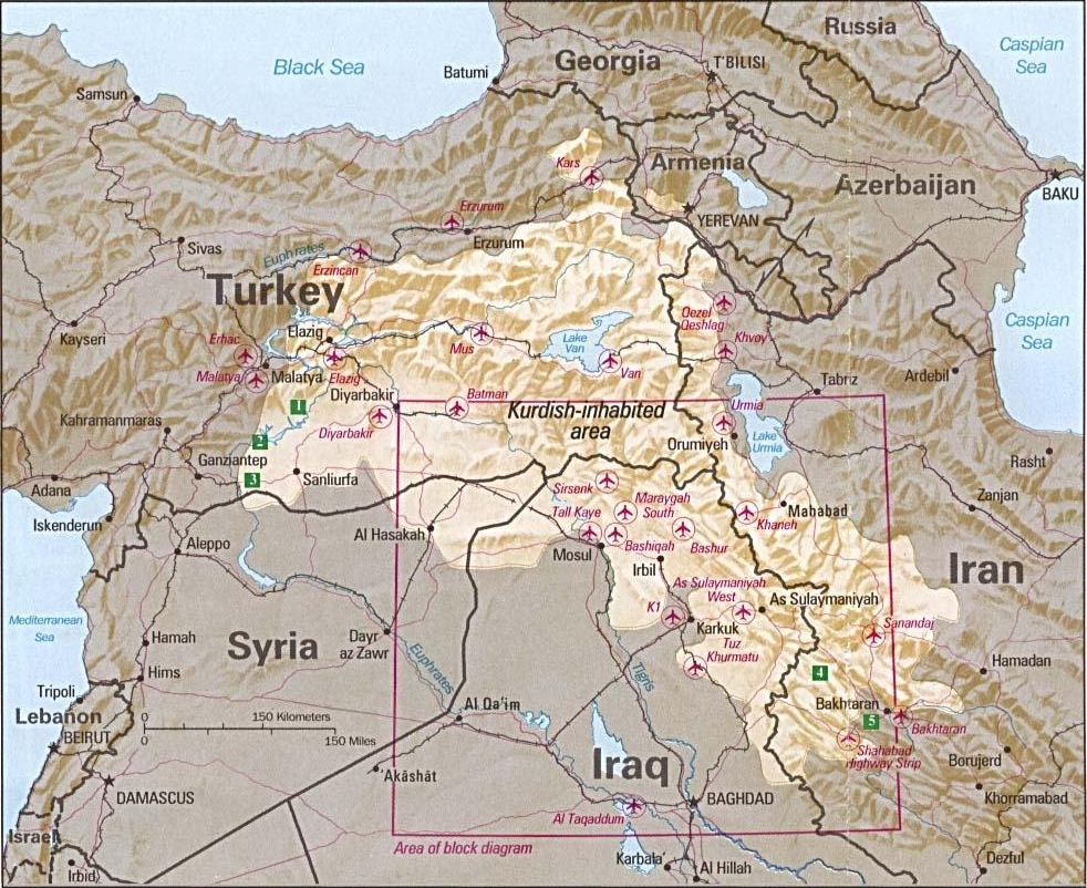
| AglamKurdish-inhabited area by CIA (1992).jpg |
Ελληνικά: Περιοχές κατοικούμενες από Κούρδους κατά τη CIA (1992) |
|||
| Azemz | August 1992 or earlier | |||
| Aɣbalu |
Perry-Castañeda Library Map Collection at The University of Texas at Austin [1] linked from Perry-Castañeda Library Map Collection at The University of Texas at Austin |
|||
| Ameskar |
English: Source stated "The following maps were produced by the U.S. Central Intelligence Agency, unless otherwise indicated." The original, non-cropped map also states: "Boundary representation is not necessarily authoritative". |
|||
| Autres versions |
|

Veuillez éviter d’écraser les fichiers originaux: un recadrement ou autre travail de restauration devrait être versé sous un autre nom et lié depuis cette page via le paramètre "other versions=", de sorte que ce fichier soit l’exacte copie de celui présente dans le catalogue CIA. Les métadonnées présentes sur cette page ont été importées depuis le catalogue CIA ; les informations additionnelles peuvent être ajoutées par les Wikimédiens via le paramètre "description=".
(Remarque: Les éditeurs qui publient le présent avis sont vivement encouragés à ajouter des détails expliquant pourquoi il s'applique à ce fichier.)
Turagt
| Public domainPublic domainfalsefalse |
| Cette image est une œuvre d'un employé de la Central Intelligence Agency, réalisée dans le cadre des tâches officielles de cette personne. En tant qu’œuvre du Gouvernement des États-Unis d'Amérique, ce document est placé dans le domaine public aux États-Unis d'Amérique.
čeština ∙ Deutsch ∙ eesti ∙ English ∙ español ∙ français ∙ italiano ∙ português ∙ polski ∙ sicilianu ∙ slovenščina ∙ suomi ∙ Tiếng Việt ∙ български ∙ македонски ∙ русский ∙ українська ∙ বাংলা ∙ മലയാളം ∙ 한국어 ∙ 日本語 ∙ 中文 ∙ 中文(简体) ∙ 中文(繁體) ∙ العربية ∙ پښتو ∙ +/− |

|
See also
- File:Kurdish lands 92.jpg - cropped and down-scaled version of same map apparently first uploaded at English wikipedia in 12 May 2003 from [2] and transferred to Commons on 2007-09-08
- Image:Kurdish lands 92 cropped.jpg - apparently cropped on 15 Jun 2003 (see w:en:Talk:Kurdish people/Archive 1) moved to Commons on or before 2006-12-16 but deleted on 9 February 2007 with comment: Superceeded ny Image:Kurdish-inhabited area by CIA (1992).jpg
Légendes
type MIME Tafransist
image/jpeg
Amazray n ufaylu
Senned ɣef yiwen azmez d usrag iwakken ad ẓṛeḍ afaylu aken yella deg imir nni.
| Azemz/Ssaɛa | Aqmamaḍ | Iseggiwen | Amseqdac | Awennit | |
|---|---|---|---|---|---|
| Lux a | 20 Ɣuct 2010 à 07:47 | | 982 × 802 (630 KB/KO) | Sv1xv | Reverted to version as of 18:21, 9 February 2007 |
| 19 Ɣuct 2010 à 20:47 |  | 975 × 795 (177 KB/KO) | Saadwand | Reverted to version as of 10:05, 7 August 2010 | |
| 18 Ɣuct 2010 à 05:15 |  | 975 × 795 (556 KB/KO) | Kintetsubuffalo | make a new map, stop warring, per discussion | |
| 17 Ɣuct 2010 à 20:51 |  | 975 × 795 (177 KB/KO) | Daryai | Reverted to version as of 12:55, 14 August 2010 | |
| 14 Ɣuct 2010 à 15:13 |  | 975 × 795 (556 KB/KO) | Kintetsubuffalo | we're not going to edit war on this-create your own map | |
| 14 Ɣuct 2010 à 12:55 |  | 975 × 795 (177 KB/KO) | Abuadab | Reverted to version as of 10:05, 7 August 2010 | |
| 13 Ɣuct 2010 à 21:48 |  | 975 × 795 (556 KB/KO) | Prosfilaes | It's a CIA map as of 1992; if you want to update it, feel free to copy it | |
| 13 Ɣuct 2010 à 20:45 |  | 975 × 795 (177 KB/KO) | Leosan | Reverted to version as of 10:05, 7 August 2010 | |
| 7 Ɣuct 2010 à 18:14 |  | 975 × 795 (556 KB/KO) | Kintetsubuffalo | changes fundaments of CIA map for that date. if you want to update, make a new map with a different date | |
| 7 Ɣuct 2010 à 10:05 |  | 975 × 795 (177 KB/KO) | Saadwand | River coloured. |
Aseqdec n ufaylu
Asebter agi teseqdac afaylu agi :
Aseqdec n ufaylu amatu
Iwikiyen-agi-nniḍen seqdacen afaylu-agi:
- Aseqdec ɣef an.wikipedia.org
- Aseqdec ɣef ar.wikipedia.org
- Aseqdec ɣef ar.wikiversity.org
- Aseqdec ɣef ast.wikipedia.org
- Aseqdec ɣef azb.wikipedia.org
- Aseqdec ɣef be.wikipedia.org
- Aseqdec ɣef bn.wikipedia.org
- Aseqdec ɣef br.wikipedia.org
- Aseqdec ɣef ca.wikipedia.org
- Aseqdec ɣef ca.wikinews.org
- Aseqdec ɣef ce.wikipedia.org
- Aseqdec ɣef ckb.wikipedia.org
- Aseqdec ɣef cs.wikipedia.org
- Aseqdec ɣef da.wikipedia.org
- Aseqdec ɣef de.wikipedia.org
- Irak
- Kurden
- Portal:Kurdistan
- Portal:Kurdistan/Willkommen
- Wikipedia:WikiProjekt Kurdistan
- Wikipedia:WikiProjekt Kurdistan/Intro
- Wikipedia:WikiProjekt Kurdistan/Benutzer
- Wikipedia:WikiProjekt Kurdistan/Teilnehmer
- Benutzer:Bohater/ Kurdisch
- Wikipedia:WikiProjekt Kurdistan/Benutzer Box
- Benutzer:Bohater/Spielwiese
- Wikipedia:WikiProjekt Kurdistan/logo
- Benutzer:Projekt-Till/In Memoriam
- Benutzer:Yoda41
- Diskussion:Völkermord an den irakischen Turkmenen
- Aseqdec ɣef dsb.wikipedia.org
- Aseqdec ɣef el.wikipedia.org
- Aseqdec ɣef en.wikipedia.org
Wali l’utilisation globale n ufaylu-agi.
.jpg)
.jpg)