ファイル:Heathrow_Before_World_War_II_Map.jpg
ウィキペディア フリーな encyclopedia
元のファイル (1,422 × 740 ピクセル、ファイルサイズ: 398キロバイト、MIME タイプ: image/jpeg)
ウィキメディア・コモンズのファイルページにある説明を、以下に表示します。
|
概要
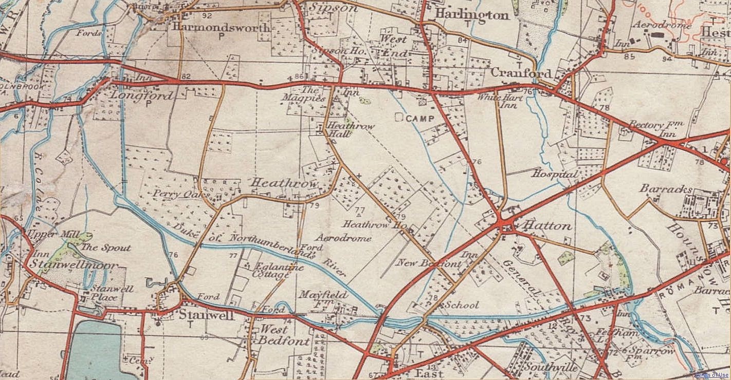
This map is an extract of an old Ordnance Survey map from before World War II which is out of copyright. See Licensing below for details of the source of this image. --DavidCane 23:55, 18 February 2007 (UTC)
Caesar's Camp, wrongly attributed
The camp marked was one of the many supposed "Caesar's Camps", also called Schapsbury Hill and Shasbury Hill, a square, Early Iron Age, British (not Roman) fort site of c. 500 BC, south of Bath Road, about halfway between Heathrow Road and Hatton Road, and a bit north of due east of Heathrow Hall. It was about (90 m) square (c. 1820 measurement) or (120 m) square (1911 measurement). It survived because it was on common land until the enclosure of the Commons of Harmondsworth parish in 1819, after which the fort's ramparts were mostly and fairly quickly ploughed out.
It was excavated hurriedly in 1944: see timeline in the article on Heathrow (hamlet). Inside its rampart 15 circular hut sites were found, and a large rectangular building which was probably a temple. The east end of the north runway obliterated it.
Road names
- Red (arterial)
- Bath Road: the quite straight, east-west road. Note the slight fork formed by the 1926-built Colnbrook (and Longford) by-pass.
- Yellow (non-arterial)
- Cain's Lane: northeast of the aerodrome. It ran 1950 metres. Its south end stays as a suburban street in New Bedfont and opposite the Great South West Road for 150 metres as a Heathrow internal minor vehicle track. A farming family was associated with it including Isaac Cane or Cain. On Enclosure of the Commons into farmland in 1819, he was awarded land to found Cain's Farm.
- High Tree Lane: narrow lane west of the aerodrome. It ran 630 metres to a ford and footbridge over the Duke of Northumberland's River.
- That ford officially was called Goathouse Tree Ford, but the local people called the ford area High Tree River/Ford.
- Goathouse Road: runs 770 metres south from that ford into Long Lane (West Bedfont, Stanwell). May have been named after an enclosure called Goathouse Close which was in the area before.
- Heathrow Road: runs south past Heathrow Hall former farmstead, then turns west forking in Perry Oaks farm. A narrow yard east of The Three Magpies pub (into its car park) is a narrowed remnant of its north end: see Google Earth map link. It briefly dates to the era of road numbering, namely as the B379.
- Hatton Road: the road at a \-type angle to the right of the word CAMP and running to Hatton. Its ends exist now (see this Google Earth map). Vestiges persist: partly-overgrown tarmac and (as on Google Earth's files at 3 January 2012); a crop mark on grass at the east end of the north runway; alignments of airport service buildings; the south part of the airport internal road Eastchurch Road.
- Tithe Barn Lane: road from Perry Oaks almost due north.
- Oaks Road: road from Perry Oaks southward. A bit of its south end survives in Stanwell. Once part of the B379 road.
- White (tracks)
- Long Lane (Heathrow): lane or track leading west from Tithe Barn Lane then north to the Bath Road at the edge of Longford.
ライセンス
- あなたは以下の条件に従う場合に限り、自由に
- 共有 – 本作品を複製、頒布、展示、実演できます。
- 再構成 – 二次的著作物を作成できます。
- あなたの従うべき条件は以下の通りです。
- 表示 – あなたは適切なクレジットを表示し、ライセンスへのリンクを提供し、変更があったらその旨を示さなければなりません。これらは合理的であればどのような方法で行っても構いませんが、許諾者があなたやあなたの利用行為を支持していると示唆するような方法は除きます。
- 継承 – もしあなたがこの作品をリミックスしたり、改変したり、加工した場合には、あなたはあなたの貢献部分を元の作品とこれと同一または互換性があるライセンスの下に頒布しなければなりません。
キャプション
このファイルに描写されている項目
題材
ファイルの履歴
過去の版のファイルを表示するには、その版の日時をクリックしてください。
| 日付と時刻 | サムネイル | 寸法 | 利用者 | コメント | |
|---|---|---|---|---|---|
| 現在の版 | 2013年12月4日 (水) 09:08 | | 1,422 × 740(398キロバイト) | Anthony Appleyard | The previous image, sharpened in Paintshop Pro, and some wear damage (to the original paper map) repaired along the river Colne near the west edge. |
| 2012年2月5日 (日) 12:05 |  | 1,422 × 740(208キロバイト) | Anthony Appleyard | More area | |
| 2008年10月4日 (土) 22:35 |  | 525 × 368(158キロバイト) | DavidCane | ==Summary== This map is an extract of an old Ordnance Survey map from before Word War II which is out of copyright. See Licensing below for details of the source of this image. --DavidCane 23:55, 18 February 2007 ( |
ファイルの使用状況
以下のページがこのファイルを使用しています:
グローバルなファイル使用状況
以下に挙げる他のウィキがこの画像を使っています:
- de.wikipedia.org での使用状況
- en.wikipedia.org での使用状況
- nl.wikipedia.org での使用状況
- no.wikipedia.org での使用状況
- zh.wikipedia.org での使用状況
メタデータ
このファイルには、追加情報があります (おそらく、作成やデジタル化する際に使用したデジタルカメラやスキャナーが追加したものです)。
このファイルが元の状態から変更されている場合、修正されたファイルを完全に反映していない項目がある場合があります。
| 画像の幅 | 1,422 ピクセル |
|---|---|
| 画像の高さ | 740 ピクセル |
| 画像方向 | 通常 |
| 水平方向の解像度 | 96dpi |
| 垂直方向の解像度 | 96dpi |
| 使用ソフトウェア名 | PaintShop Pro 16.00 |