ファイル:Germany_general_map.png
ウィキペディア フリーな encyclopedia
このプレビューのサイズ: 471 × 599 ピクセル。 その他の解像度: 189 × 240 ピクセル | 377 × 480 ピクセル | 603 × 768 ピクセル | 805 × 1,024 ピクセル | 1,979 × 2,518 ピクセル。
元のファイル (1,979 × 2,518 ピクセル、ファイルサイズ: 7メガバイト、MIME タイプ: image/png)
ウィキメディア・コモンズのファイルページにある説明を、以下に表示します。
|
|
概要
| 解説Germany general map.png |
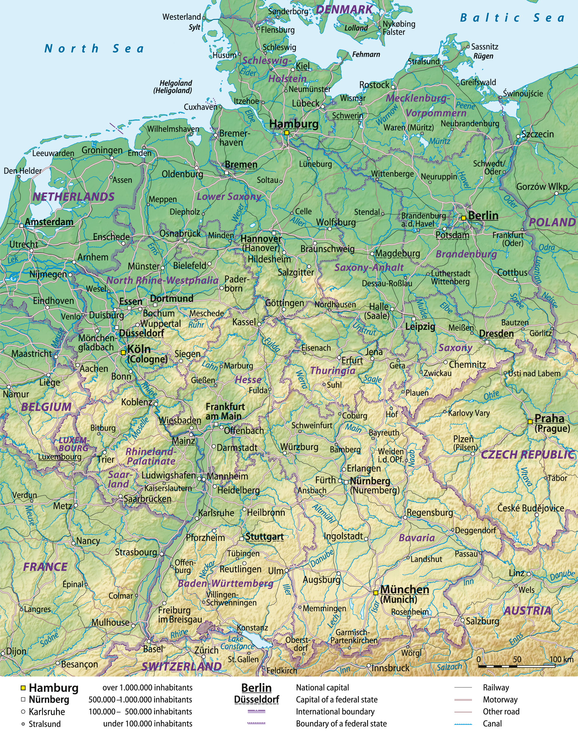
Deutsch: Übersichtskarte von Deutschland, englische Version
English: General map of Germany, English version
Français : Carte générale de l'Allemagne, en anglais |
||
| 日付 | 08-06-2008 | ||
| 原典 |
Self made, using Generic Mapping Tools (source code below), based on United States National Imagery and Mapping Agency data.
|
||
| 作者 | Lencer and NordNordWest | ||
| 許可 (ファイルの再利用) |
この作品の著作権者である私は、この作品を以下のライセンスで提供します。
このファイルはクリエイティブ・コモンズ 表示-継承 3.0 非移植ライセンスのもとに利用を許諾されています。
あなたは上記のライセンスから、どれか一つ以上を選択できます。 |
||
| その他のバージョン |


Source code
- color_table based of fr:Aide:Cartographie:
# ih_land_de.cpt
   0 148 191 139    200 189 204 150
 200 189 204 150    500 239 235 192
 500 239 235 192   1000 222 214 163
1000 222 214 163   2000 202 185 130
2000 202 185 130   5000 192 154  83
B 148 191 139
F 192 154  83
N 148 191 139
- Creating the background with Generic Mapping Tools (GMT) アーカイブされたコピー at the Wayback Machine and Globe
xyz2grd c10g -R0/90/50/90 -I30c -N-500 -F -ZTLh -Gc10g.grd
xyz2grd g10g -R0/90/0/50 -I30c -N-500 -F -ZTLh -Gg10g.grd
grdpaste c10g.grd g10g.grd -Gih_land_de.grd
grdgradient ih_land_de.grd -A305 -Ne0.2 -Gih_schatten_de.grd
pscoast -JL10/51/42/54/18c -R5/47/16/55r -Gc -Dh -P -K >ih_de.ps
grdimage ih_land_de.grd -Iih_schatten_de.grd -Cih_land_de.cpt -JL10/51/42/54/18c -R5/47/16/55r -P -K -O >>ih_de.ps
pscoast -JL10/51/42/54/18c -R5/47/16/55r -Q -O >>ih_de.ps
See the German GMT-helppage for further instructions.
キャプション
このファイルの内容を1行で記述してください
このファイルに描写されている項目
題材
ファイルの履歴
過去の版のファイルを表示するには、その版の日時をクリックしてください。
| 日付と時刻 | サムネイル | 寸法 | 利用者 | コメント | |
|---|---|---|---|---|---|
| 現在の版 | 2012年12月29日 (土) 16:44 | | 1,979 × 2,518 (7メガバイト) | NordNordWest | update |
| 2009年10月4日 (日) 10:19 |  | 1,979 × 2,518 (6.56メガバイト) | NordNordWest | ||
| 2008年6月16日 (月) 14:03 |  | 1,979 × 2,521 (6.81メガバイト) | NordNordWest | ||
| 2008年6月8日 (日) 20:17 |  | 1,979 × 2,521 (6.79メガバイト) | NordNordWest | == Beschreibung == {{Information |Description= {{de|Übersichtskarte von Deutschland, englische Version}} {{en|General map of Germany, English version}} {{fr|Carte générale d'Allemagne, en anglais}} |
ファイルの使用状況
以下の 3 ページがこのファイルを使用しています:
グローバルなファイル使用状況
以下に挙げる他のウィキがこの画像を使っています:
- af.wikipedia.org での使用状況
- bg.wikipedia.org での使用状況
- cy.wikipedia.org での使用状況
- de.wikipedia.org での使用状況
- en.wikipedia.org での使用状況
- Portal:Geography
- Portal:Germany/Selected picture
- Outline of Germany
- Wikipedia:Featured pictures/Diagrams, drawings, and maps/Maps
- User talk:Spencer/Archive 2
- User talk:NordNordWest
- Wikipedia:Featured pictures thumbs/15
- Wikipedia:Featured picture candidates/February-2009
- Wikipedia:Featured picture candidates/Germany general map
- Wikipedia:Wikipedia Signpost/2009-02-16/Features and admins
- Wikipedia:Picture of the day/October 2009
- Template:POTD/2009-10-03
- User talk:Spencer/Archive 10
- Wikipedia:Wikipedia Signpost/2009-02-16/SPV
- Portal:Geography/Selected picture
- Wikipedia:Wikipedia Signpost/Single/2009-02-16
- User:Falcaorib/Germany and Prussia
- fa.wikipedia.org での使用状況
- fr.wikipedia.org での使用状況
- mk.wikipedia.org での使用状況
- no.wikipedia.org での使用状況
- pt.wikipedia.org での使用状況
- simple.wikipedia.org での使用状況
- srn.wikipedia.org での使用状況
- uk.wikipedia.org での使用状況
- zh.wikipedia.org での使用状況
メタデータ
このファイルには、追加情報があります (おそらく、作成やデジタル化する際に使用したデジタルカメラやスキャナーが追加したものです)。
このファイルが元の状態から変更されている場合、修正されたファイルを完全に反映していない項目がある場合があります。
| 水平方向の解像度 | 78.74dpc |
|---|---|
| 垂直方向の解像度 | 78.74dpc |