File:WW2_Holocaust_Europe_map-de.png
ウィキペディア フリーな encyclopedia
このプレビューのサイズ: 721 × 600 ピクセル。 その他の解像度: 289 × 240 ピクセル | 577 × 480 ピクセル | 923 × 768 ピクセル | 1,231 × 1,024 ピクセル | 2,461 × 2,048 ピクセル | 2,729 × 2,271 ピクセル。
元のファイル (2,729 × 2,271 ピクセル、ファイルサイズ: 660キロバイト、MIME タイプ: image/png)
ウィキメディア・コモンズのファイルページにある説明を、以下に表示します。
|
概要
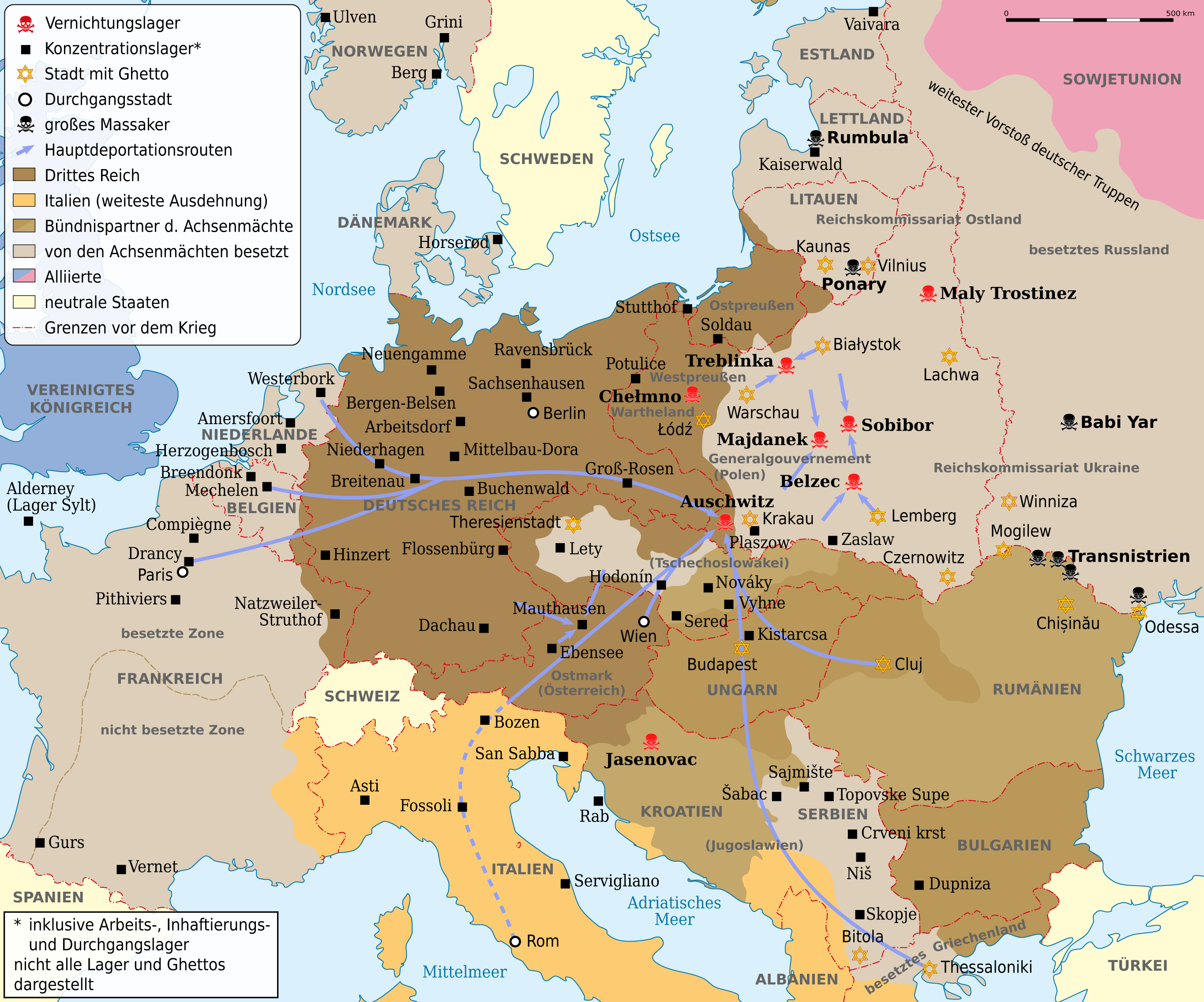
| 解説WW2 Holocaust Europe map-de.png |
Deutsch: Karte der Vernichtungslager, der meisten großen Konzentrationslager (Arbeits-, Inhaftierungs- und Durchgangslager), der Hauptdeportationsrouten, Ghettos und Orten großer Massaker. Grenzen etwa 1942. Vor- und Nachkriegsstaatennamen in Klammern. English: Map of the extermination camps, most of the major concentration camps (labor, detention and transit camp), the main deportation routes, ghettos and places great massacre. Limits about the 1942nd Pre-and post-conflict states name in parentheses |
| 日付 | |
| 原典 |
このファイルの派生元: WW2 Holocaust Europe map-fr.svg |
| 作者 |
|
この画像には画像編集が施されています。原本に対して次のデジタル的な変更が行われました。
|
ライセンス
この作品の著作権者である私は、この作品を以下のライセンスで提供します。
| コピーレフト: この芸術作品はフリーです。あなたは、自由芸術ライセンスの規約に従うことで、再配布や改変が可能です。このライセンスの見本は、Copyleft Attitude または他のウェブサイトで見ることができます。 http://artlibre.org/licence/lal/enFALFree Art Licensefalsetrue |
元のアップロードログ
This image is a derivative work of the following images:
- File:WW2_Holocaust_Europe_map-fr.svg licensed with FAL
- 2011-09-28T13:32:55Z Sémhur 1310x1090 (502755 Bytes) Location of Varsovie, border between Poland and East Prussia
- 2009-05-11T16:52:07Z Sémhur 1310x1090 (607330 Bytes) {{Information |Description=Map of the Holocaust in Europe during World War II, 1939-1945. This map shows all extermination camps (or ''death camps''), most major concentration camps, labor camps, prison camps, ghettos, major
キャプション
このファイルの内容を1行で記述してください
Karte der Vernichtungslager, der meisten großen Konzentrationslager (Arbeits-, Inhaftierungs- und Durchgangslager), der Hauptdeportationsrouten, Ghettos und Orten großer Massaker. Grenzen etwa 1942.
このファイルに描写されている項目
題材
12 9 2012
ファイルの履歴
過去の版のファイルを表示するには、その版の日時をクリックしてください。
| 日付と時刻 | サムネイル | 寸法 | 利用者 | コメント | |
|---|---|---|---|---|---|
| 現在の版 | 2013年5月1日 (水) 08:53 | | 2,729 × 2,271 (660キロバイト) | NordNordWest | c |
| 2012年9月14日 (金) 08:03 |  | 2,729 × 2,271 (660キロバイト) | NordNordWest | c | |
| 2012年9月13日 (木) 20:45 |  | 2,729 × 2,271 (654キロバイト) | NordNordWest | c | |
| 2012年9月12日 (水) 19:07 |  | 2,729 × 2,271 (660キロバイト) | NordNordWest | == {{int:filedesc}} == {{Information |Description={{de|Karte der Vernichtungslager, der meisten großen Konzentrationslager (Arbeits-, Inhaftierungs- und Durchgangslager), der Hauptdeportationsrouten, Ghettos und Orten großer Massaker. Grenzen etwa 19... |
ファイルの使用状況
このファイルを使用しているページはありません。
グローバルなファイル使用状況
以下に挙げる他のウィキがこの画像を使っています:
- ca.wikipedia.org での使用状況
- de.wikipedia.org での使用状況
- Deportation
- Holocaust
- Durchgangslager Fossoli
- Deutsche Besetzung Polens 1939–1945
- Konzentrationslager
- Durchgangslager Bozen
- Eichmannreferat
- Wikipedia:Kartenwerkstatt/Archiv/2012-09
- Deutsche Besetzung Frankreichs im Zweiten Weltkrieg
- Diskussion:Gesetz über das Institut des Nationalen Gedenkens – Kommission für die Verfolgung von Verbrechen gegen das Polnische Volk
- ga.wikipedia.org での使用状況
- ksh.wikipedia.org での使用状況
- no.wikipedia.org での使用状況
- stq.wikipedia.org での使用状況
- uk.wikipedia.org での使用状況
- www.wikidata.org での使用状況
メタデータ
このファイルには、追加情報があります (おそらく、作成やデジタル化する際に使用したデジタルカメラやスキャナーが追加したものです)。
このファイルが元の状態から変更されている場合、修正されたファイルを完全に反映していない項目がある場合があります。
| 水平方向の解像度 | 59.06dpc |
|---|---|
| 垂直方向の解像度 | 59.06dpc |
| 使用ソフトウェア名 |
|