File:München_-_Stadtbezirke_(Karte).png
Da Wikipedia, l'enciclopedia encyclopedia
File originale (2 119 × 1 641 pixel, dimensione del file: 338 KB, tipo MIME: image/png)
| Questo file e la sua pagina di descrizione (discussione · modifica) si trovano su Wikimedia Commons (?) |
Articles about the boroughs of Munich in the German Wikipedia (original list)
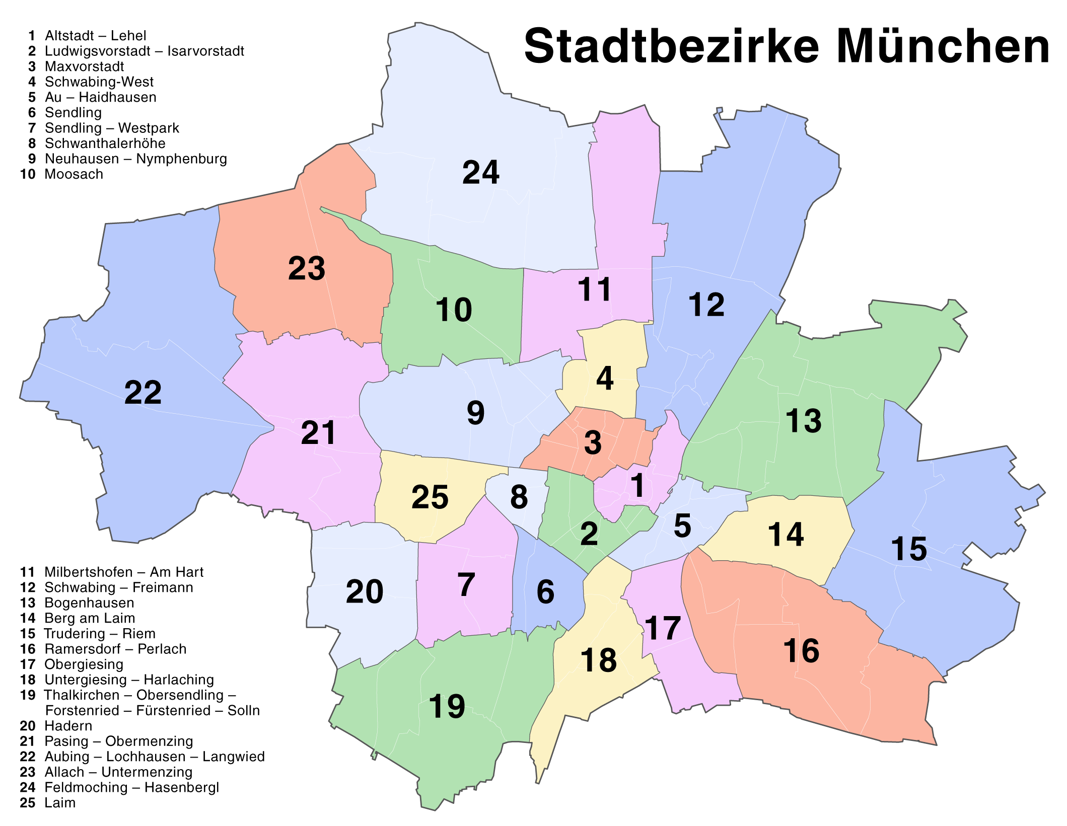
23 Allach-Untermenzing - 1 Altstadt-Lehel - 22 Aubing-Lochhausen-Langwied - 5 Au-Haidhausen - 14 Berg am Laim - 13 Bogenhausen - 24 Feldmoching-Hasenbergl - 20 Hadern - 25 Laim - 2 Ludwigsvorstadt-Isarvorstadt - 3 Maxvorstadt - 11 Milbertshofen-Am Hart - 10 Moosach - 9 Neuhausen-Nymphenburg - 17 Obergiesing - 21 Pasing-Obermenzing - 16 Ramersdorf-Perlach - 12 Schwabing-Freimann - 4 Schwabing-West - 8 Schwanthalerhöhe - 6 Sendling - 7 Sendling-Westpark - 19 Thalkirchen-Obersendling-Forstenried-Fürstenried-Solln - 15 Trudering-Riem - 18 Untergiesing-Harlaching
| DescrizioneMünchen - Stadtbezirke (Karte).png |
Deutsch: Kartenserie der Münchner Stadtbezirke
English: Boroughs of Munich map series |
||
| Data | |||
| Fonte | Self made, created with Adobe Illustrator 12.0 | ||
| Autore | Maximilian Dörrbecker (Chumwa) | ||
| Licenza (Riusare questo file) |
This map was created by Maximilian Dörrbecker. Attribution to Wikipedia or another project of the Wikimedia foundation is required if it is used outside of projects of the Wikimedia foundation. Questo file è disponibile in base alla licenza Creative Commons Attribuzione-Condividi allo stesso modo 2.5 Generico
"I want to use the image. How do I do that?" You can use this map freely for any purpose, including commercial use, provided that you license it under the above license. My suggestion is to use the following text:
|
||
| Altre versioni |
Die Serie besteht aus den folgenden Karten / The series consists of the following maps : Region München:
Stadt München:
|


.png)


.png)
.png)


_-_Altstadt_-_Lehel.png)
_-_Ludwigsvorstadt_-_Isarvorstadt.png)
_-_Maxvorstadt.png)
_-_Schwabing-West.png)
_-_Au_-_Haidhausen.png)
_-_Sendling.png)
_-_Sendling_-_Westpark.png)
_-_Schwanthalerh%C3%B6he.png)
_-_Neuhausen_-_Nymphenburg.png)
_-_Moosach.png)
_-_Milbertshofen_-_Am_Hart.png)
_-_Bogenhausen.png)
_-_Berg_am_Laim.png)
_-_Trudering_-_Riem.png)
_-_Ramersdorf_-_Perlach.png)
_-_Obergiesing.png)
_-_Thalkirchen_-_Obersendling_-_Forstenried_-_F%C3%BCrstenried_-_Solln.png)
_-_Hadern.png)
_-_Pasing_-_Obermenzing.png)
_-_Aubing_-_Lochhausen_-_Langwied.png)
_-_Allach_-_Untermenzing.png)
_-_Feldmoching_-_Hasenbergl.png)
_-_Laim.png)
Didascalie
Elementi ritratti in questo file
raffigura
agosto 2007
Cronologia del file
Fare clic su un gruppo data/ora per vedere il file come si presentava nel momento indicato.
| Data/Ora | Miniatura | Dimensioni | Utente | Commento | |
|---|---|---|---|---|---|
| attuale | 18:22, 20 ago 2007 | | 2 119 × 1 641 (338 KB) | Chumwa | Correction of the district numbering in the named list (many thanks to Andreas for the error hint!) |
| 18:16, 18 ago 2007 |  | 2 119 × 1 641 (342 KB) | Chumwa | {{Information |Description= *{{ de }} Kartenserie der Münchner Stadtbezirke *{{ en }} Boroughs of Munich map series |Source=Self made, created with Adobe Illustrator 12.0 |Date=August 2007 |Author=Maximilian Dörrbecker ([[:de:User:Ch |
Pagine che usano questo file
Nessuna pagina utilizza questo file.
Utilizzo globale del file
Anche i seguenti wiki usano questo file:
- Usato nelle seguenti pagine di ba.wikipedia.org:
- Usato nelle seguenti pagine di bxr.wikipedia.org:
- Usato nelle seguenti pagine di de.wikipedia.org:
- Usato nelle seguenti pagine di en.wikipedia.org:
- Usato nelle seguenti pagine di fr.wikipedia.org:
- Usato nelle seguenti pagine di kk.wikipedia.org:
- Usato nelle seguenti pagine di lez.wikipedia.org:
- Usato nelle seguenti pagine di pl.wikivoyage.org:
- Usato nelle seguenti pagine di ru.wikipedia.org:
- Usato nelle seguenti pagine di vep.wikipedia.org:
.png)