Mynd:Polish-Lithuanian_commonwealth_1619_map.png
From Wikipedia, the free encyclopedia
Það er engin hærri upplausn til.
Polish-Lithuanian_commonwealth_1619_map.png (791 × 375 mynddílar, skráarstærð: 41 KB, MIME-gerð: image/png)
Skrá þessi er af Wikimedia Commons, og deilt meðal annarra verkefna og nýtist því þar. Hér fyrir neðan er afrit af skráarsíðunni þar.

|
This historical map image could be re-created using vector graphics as an SVG file. This has several advantages; see Commons:Media for cleanup for more information. If an SVG form of this image is available, please upload it and afterwards replace this template with
{{vector version available|new image name}}.
It is recommended to name the SVG file “Polish-Lithuanian commonwealth 1619 map.svg”—then the template Vector version available (or Vva) does not need the new image name parameter. |
Lýsing
| LýsingPolish-Lithuanian commonwealth 1619 map.png |
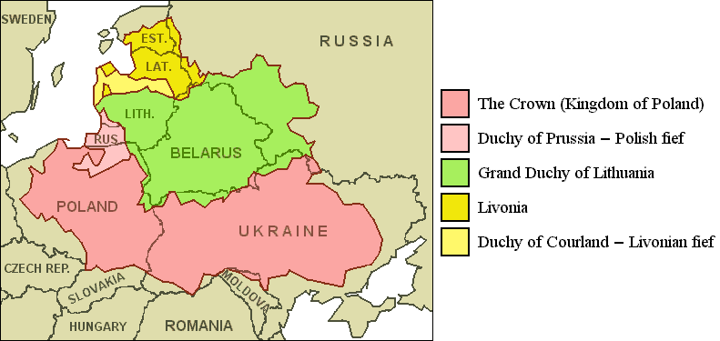
English: Polish-Lithuanian Commonwealth (1619) compared with today's borders. |
| Dagsetning | |
| Uppruni | JPEG-version with artifacts: File:Pol-lith commonwealth map.jpg |
| Höfundarréttarhafi | "Roel van der Hoorn (Van der Hoorn)"; original author: Knutux |
| Aðrar útgáfur | File:Rzeczpospolita265.png (finer borders, different colors, expanded names) |
Leyfisupplýsingar:

|
Gefið er leyfi til að afrita, dreifa og/eða breyta þessu skjali samkvæmt Frjálsa GNU Free Documentation License, útgáfu 1.2 eða nýrri, sem gefið er út af Frjálsu hugbúnaðarstofnuninni með engum breytingum þar á. Afrit af leyfinu er innifalið í kaflanum GNU Free Documentation License.http://www.gnu.org/copyleft/fdl.htmlGFDLGNU Free Documentation Licensetruetrue |
Þessi skrá er með Creative Commons Tilvísun-DeilaEins 3.0 Óstaðfært notkunarleyfi.
Tilvísun höfundarréttar: GFDL
- Þér er frjálst:
- að deila – að afrita, deila og yfirfæra verkið
- að blanda – að breyta verkinu
- Undir eftirfarandi skilmálum:
- tilvísun höfundarréttar – Þú verður að tilgreina viðurkenningu á höfundarréttindum, gefa upp tengil á notkunarleyfið og gefa til kynna ef breytingar hafa verið gerðar. Þú getur gert þetta á einhvern ásættanlegan máta, en ekki á nokkurn þann hátt sem bendi til þess að leyfisveitandinn styðji þig eða notkun þína á verkinu.
- Deila eins – Ef þú breytir, yfirfærir eða byggir á þessu efni, þá mátt þú eingöngu dreifa því verki með sama eða svipuðu leyfi og upprunalega verkið er með.
Captions
Add a one-line explanation of what this file represents
Items portrayed in this file
depicts enska
copyright status enska
copyrighted enska
29. ágúst 2010
Breytingaskrá skjals
Smelltu á dagsetningu eða tímasetningu til að sjá hvernig hún leit þá út.
| Dagsetning/Tími | Smámynd | Víddir | Notandi | Athugasemd | |
|---|---|---|---|---|---|
| núverandi | 29. ágúst 2010 kl. 13:04 | | 791 × 375 (41 KB) | Van der Hoorn | {{Information |Description={{en|1=Polish-Lithuanian Commonwealth (1619) compared with today's borders.}} |Source=JPEG-version with artifacts: File:Pol-lith_commonwealth_map.jpg |Author="Roel van der Hoorn (Van der Hoorn)" |Da |
Skráartenglar
Eftirfarandi síða notar þessa skrá:
Altæk notkun skráar
Eftirfarandi wikar nota einnig þessa skrá:
- Notkun á ast.wikipedia.org
- Notkun á bg.wikipedia.org
- Notkun á br.wikipedia.org
- Notkun á da.wikipedia.org
- Notkun á de.wikipedia.org
- Notkun á en.wikipedia.org
- Notkun á eo.wikipedia.org
- Notkun á fr.wikipedia.org
- Notkun á gl.wikipedia.org
- Notkun á it.wikipedia.org
- Notkun á ja.wikipedia.org
- Notkun á nl.wikipedia.org
- Notkun á oc.wikipedia.org
- Notkun á pt.wikipedia.org
- Notkun á ro.wikipedia.org
- Notkun á scn.wikipedia.org
- Notkun á sv.wikipedia.org
- Notkun á vec.wikipedia.org
- Notkun á zh.wikipedia.org