Mynd:PNW-straits.jpg
From Wikipedia, the free encyclopedia
PNW-straits.jpg (336 × 396 mynddílar, skráarstærð: 128 KB, MIME-gerð: image/jpeg)
Skrá þessi er af Wikimedia Commons, og deilt meðal annarra verkefna og nýtist því þar. Hér fyrir neðan er afrit af skráarsíðunni þar.
This image is very small, unfixably too light/dark, or may not adequately illustrate the subject of the image If a higher-quality version of this particular image is available, please replace this one; otherwise, a supplemental image illustrating this subject and available under a free license should be found or provided and uploaded as a separate file.
Please see Category:Image cleanup templates for templates used to mark images that only need a clean-up. For more help, see Commons:Media for cleanup#Low quality images. Deutsch ∙ català ∙ English ∙ čeština ∙ español ∙ sicilianu ∙ Tiếng Việt ∙ ಕನ್ನಡ ∙ 日本語 ∙ polski ∙ മലയാളം ∙ galego ∙ македонски ∙ 中文(简体) ∙ 中文(繁體) ∙ العربية ∙ русский ∙ 中文 ∙ suomi ∙ 中文(臺灣) ∙ norsk ∙ Nederlands ∙ Plattdüütsch ∙ svenska ∙ français ∙ magyar ∙ 한국어 ∙ italiano ∙ português ∙ беларуская (тарашкевіца) ∙ +/− |
Lýsing
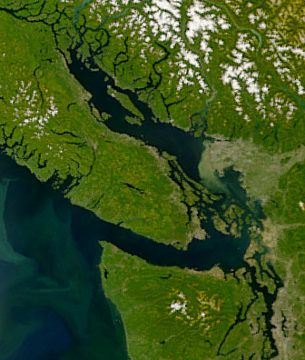
| LýsingPNW-straits.jpg | Satellite image of the Strait of Georgia, Strait of Juan de Fuca, and surrounding region. The image was acquired by the Sea-viewing Wide Field-of-view Sensor (SeaWiFS) on August 9, 2001. Original image cropped to highlight the Strait of Georgia. |
| Dagsetning | |
| Uppruni | NASAEarth Observatory, http://earthobservatory.nasa.gov/Newsroom/NewImages/images.php3?img_id=5051 |
| Höfundarréttarhafi | The SeaWiFS Project, NASA/Goddard Space Flight Center, and ORBIMAGE |
Leyfisupplýsingar:
| Public domainPublic domainfalsefalse |
| This image is from the Sea-viewing Wide Field-of-view Sensor (SeaWiFS) Project and more than 5 years old.
Satellite data captured by the SeaWIFS sensor are released into the public domain 5 years after capture. Data less than five years old can be re-used only for educational or scientific purposes; any commercial use of such images must be coordinated with GeoEye. [1] |
| Public domainPublic domainfalsefalse |
| This work has been released into the public domain by its copyright holder, GeoEye. This applies worldwide. In some countries this may not be legally possible; if so: GeoEye grants anyone the right to use this work for any purpose, without any conditions, unless such conditions are required by law. Public domainPublic domainfalsefalse |
Captions
Items portrayed in this file
depicts enska
9. ágúst 2001
Breytingaskrá skjals
Smelltu á dagsetningu eða tímasetningu til að sjá hvernig hún leit þá út.
| Dagsetning/Tími | Smámynd | Víddir | Notandi | Athugasemd | |
|---|---|---|---|---|---|
| núverandi | 22. apríl 2008 kl. 06:55 | | 336 × 396 (128 KB) | Pfly | {{Information |Description=Satellite image of the Strait of Georgia, Strait of Juan de Fuca, and surrounding region. The image was acquired by the Sea-viewing Wide Field-of-view Sensor (SeaWiFS) on |
Skráartenglar
Eftirfarandi síða notar þessa skrá:
Altæk notkun skráar
Eftirfarandi wikar nota einnig þessa skrá:
- Notkun á ar.wikipedia.org
- Notkun á ast.wikipedia.org
- Notkun á az.wikipedia.org
- Notkun á br.wikipedia.org
- Notkun á ca.wikipedia.org
- Notkun á cv.wikipedia.org
- Notkun á de.wikipedia.org
- Notkun á en.wikipedia.org
- Notkun á eo.wikipedia.org
- Notkun á es.wikipedia.org
- Notkun á fa.wikipedia.org
- Notkun á fi.wikipedia.org
- Notkun á fr.wikipedia.org
- Notkun á fr.wiktionary.org
- Notkun á fy.wikipedia.org
- Notkun á he.wikipedia.org
- Notkun á id.wikipedia.org
- Notkun á it.wikipedia.org
- Notkun á ja.wikipedia.org
- Notkun á ko.wikipedia.org
- Notkun á lv.wikipedia.org
- Notkun á mhr.wikipedia.org
- Notkun á mk.wikipedia.org
- Notkun á ms.wikipedia.org
- Notkun á nl.wikipedia.org
- Notkun á no.wikipedia.org
- Notkun á pl.wikipedia.org
- Notkun á pt.wikipedia.org
- Notkun á ru.wikipedia.org
- Notkun á sh.wikipedia.org
- Notkun á tr.wikipedia.org
- Notkun á uk.wikipedia.org
- Notkun á ur.wikipedia.org
- Notkun á vi.wikipedia.org
- Notkun á zh.wikipedia.org
Lýsigögn
Þessi skrá inniheldur viðbótarupplýsingar, líklega bætt við úr stafrænu myndavélinni eða skannanum sem notaður var til að búa til eða stafræna hana.
Ef skránni hefur verið breytt frá upprunalegu ástandi gæti verið að sumar upplýsingar endurspegli ekki að fullu breyttu skrána.
| Stefna | Venjuleg |
|---|---|
| Lárétt upplausn | 72 pát |
| Lóðrétt upplausn | 72 pát |
| Hugbúnaður | Adobe Photoshop CS2 Macintosh |
| Dagsetning og tími breytingar | 21. apríl 2008 kl. 23:42 |
| Litrýmd | sRGB |