Mynd:1154_world_map_by_Moroccan_cartographer_al-Idrisi_for_king_Roger_of_Sicily.jpg
From Wikipedia, the free encyclopedia

Upphafleg skrá (1.296 × 1.296 mynddílar, skráarstærð: 741 KB, MIME-gerð: image/jpeg)
Skrá þessi er af Wikimedia Commons, og deilt meðal annarra verkefna og nýtist því þar. Hér fyrir neðan er afrit af skráarsíðunni þar.
Lýsing
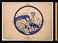
| Lýsing1154 world map by Moroccan cartographer al-Idrisi for king Roger of Sicily.jpg | en:al-Idrisi world map, Arabic from 804/1154/1456 A.D. Oriented with South at the top |
| Dagsetning | |
| Uppruni | https://sindominio.net/labiblio/varios/IdrisiMap.jpg |
| Höfundarréttarhafi | al-Idrisi |
Versions
-
 Original picture.
 -
 Cropped alternative.
 -
 This picture (cropped).


Leyfisupplýsingar:
|
This is a faithful photographic reproduction of a two-dimensional, public domain work of art. The work of art itself is in the public domain for the following reason:
The official position taken by the Wikimedia Foundation is that "faithful reproductions of two-dimensional public domain works of art are public domain". This photographic reproduction is therefore also considered to be in the public domain in the United States. In other jurisdictions, re-use of this content may be restricted; see Reuse of PD-Art photographs for details. {{PD-Art}} template without license parameter: please specify why the underlying work is public domain in both the source country and the United States
(Usage: {{PD-Art|1=|deathyear=''year of author's death''|country=''source country''}}, where parameter 1= can be PD-old-auto, PD-old-auto-expired, PD-old-auto-1996, PD-old-100 or similar. See Commons:Multi-license copyright tags for more information.) | |||||
Captions
Items portrayed in this file
depicts enska
media type enska
image/jpeg
checksum enska
08e7ce75517bd0bab3b68ad49a8f8ce0449cdad4
data size enska
759.030 Bæti
1.296 díll
1.296 díll
1456
Breytingaskrá skjals
Smelltu á dagsetningu eða tímasetningu til að sjá hvernig hún leit þá út.
| Dagsetning/Tími | Smámynd | Víddir | Notandi | Athugasemd | |
|---|---|---|---|---|---|
| núverandi | 23. ágúst 2006 kl. 03:45 | | 1.296 × 1.296 (741 KB) | Leinad-Z~commonswiki | Losslessly rotaded and cropped from http://www.sindominio.net/labiblio/varios/IdrisiMap.jpg |
| 13. september 2005 kl. 09:08 |  | 690 × 677 (122 KB) | Humus sapiens~commonswiki | Category:Historical maps of the Middle East |
Skráartenglar
Eftirfarandi síða notar þessa skrá:
Altæk notkun skráar
Eftirfarandi wikar nota einnig þessa skrá:
- Notkun á ar.wikipedia.org
- Notkun á ar.wikisource.org
- Notkun á ca.wikipedia.org
- Notkun á ckb.wikipedia.org
- Notkun á de.wikipedia.org
- Notkun á en.wikipedia.org
- Notkun á es.wikipedia.org
- Notkun á fr.wikipedia.org
- Notkun á gl.wikipedia.org
- Notkun á hr.wikipedia.org
- Notkun á id.wikipedia.org
- Notkun á it.wikipedia.org
- Notkun á it.wikiquote.org
- Notkun á ja.wikipedia.org
- Notkun á nl.wikipedia.org
- Notkun á nn.wikipedia.org
- Notkun á nrm.wikipedia.org
- Notkun á pt.wikipedia.org
- Notkun á pt.wikiquote.org
- Notkun á sh.wikipedia.org
- Notkun á ur.wikipedia.org
- Notkun á www.wikidata.org