File:Plates_tect2_ar.png
From Wikipedia, the free encyclopedia

Það er engin hærri upplausn til.
Plates_tect2_ar.png (800 × 546 mynddílar, skráarstærð: 1,67 MB, MIME-gerð: image/png)
Skrá þessi er af Wikimedia Commons, og deilt meðal annarra verkefna og nýtist því þar. Hér fyrir neðan er afrit af skráarsíðunni þar.
Lýsing
| LýsingPlates tect2 ar.png |
[breyta]
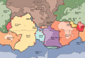
Afrikaans: Die Aarde se tektoniese plate. Bahasa Indonesia: Inti dari tektonika lempeng adalah bahwa litosfer terdiri dari lempeng-lempeng tektonik yang mengambang di atas astenosfer yang serupa fluida (padatan visko-elastik). Fluiditas relatif astenosfer memungkinkan lempeng-lempeng tektonik ini untuk mengalami pergerakan ke arah yang berbeda-beda. Peta ini menunjukkan 15 lempeng terbesar. Perhatikan bahwa Lempeng Indo-Australia bisa terbelah menjadi lempeng India dan Australia (dalam peta ini digambarkan terpisah). Català: Plaques tectòniques Čeština: Mapa tektonických desek Deutsch: Die Lithosphärenplatten der Erde Eesti: Laamade kaart English: The key principle of plate tectonics is that the lithosphere exists as separate and distinct tectonic plates, which float on the fluid-like (visco-elastic solid) asthenosphere. The relative fluidity of the asthenosphere allows the tectonic plates to undergo motion in different directions. This map shows 15 of the largest plates. Note that the Indo-Australian Plate may be breaking apart into the Indian and Australian plates, which are shown separately on this map. Español: Mapa que muestra la ubicación y movimiento de las placas tectónicas en la corteza terrestre Euskara: Plaka tektonikoen banaketa Français : Le principe clé de la tectonique des plaques est que la lithosphère rigide est formée de plaques distinctes et indépendantes, qui flottent sur l'asthénosphère visco-élastique. La fluidité relative de l'asthénosphère permet aux plaques tectoniques de faire des mouvements dans différentes directions. Cette carte montre 15 des plus grandes plaques. Notez que les plaques indienne et australienne, qui sont montrées séparément sur cette carte, soient selon les auteurs parfois regroupées en une seule plaque indo-australienne. Hrvatski: Tektonika ploča Italiano: La struttura e le placche della crosta terrestre. Lëtzebuergesch: Tektonesch Placken Lietuvių: Tektoninės plokštės. Rodyklėmis parodytos judėjimo kryptys Magyar: Tektonikus lemezek Occitan : Mapa de las placas tectonicas mai grandas del mond Srpski (latinica): Zemljine tektonske ploče Sunda: Téktonika lémpéng negeskeun yén litosfér téh diwangun ku sababaraha lémpéng téktonik anu ngambang luhureun asténosfér anu kawas cai (padetan visko-élastik). Ku ayana fluiditas rélatif asténosfér, ieu lémpéng-lémpéng téktonik bisa ojah ka mana waé. Ieu peta némbongkeun 15 lémpéng nu baradag. Imeutan yén Lémpéng Indo-Australia bisa bejad jadi lémpéng India jeung Australia, nu dina ieu peta mémang digambarkeun misah. Suomi: Suomennos maapallon mannerlaatoista ja niiden liikesuunnista. Tiếng Việt: Nguyên tắc quan trọng của kiến tạo mảng là thạch quyển tồn tại dưới dạng các mảng kiến tạo riêng biệt và khác biệt, chúng trôi nổi trên khí quyển giống như chất lỏng (chất rắn đàn hồi). Tính lưu động tương đối của khí quyển cho phép các mảng kiến tạo chuyển động theo các hướng khác nhau. Bản đồ này cho thấy 15 tấm lớn nhất. Lưu ý rằng mảng Ấn-Úc có thể tách ra thành mảng Ấn Độ và Úc, được hiển thị riêng biệt trên bản đồ này. Ελληνικά: Οι τεκτονικές πλάκες Български: Тектонски плочи Македонски: Тектонските плочи во светот. Українська: Основним принципом тектоніки плит є те, що літосфера існує як різні і відокремлені тектонічні плити, які плавають в'язкій астеносфері. Відносна рухливість астеносфери дозволяє тектонічним плитам здійснювати рухи в різних напрямках. Ця карта зображує 15 найбільших плит. Зверніть увагу, що Індо-Австралійська плита може бути розділена на Індостанську та Австралійську плити, які показані окремо на цій карті. ไทย: ภาพแสดงการวางตัวของแผ่นเปลือโลก 한국어: 판구조지질학(plate tectonics)의 핵심 원리는 암석권(lithosphere)이 지질구조판들로 따로 존재하면서, 액체같은(점탄성 고체) 연약권(asthenosphere) 위에 떠 있다는 것입니다. 연약권이 상대적으로 액상이어서, 지질구조판들이 다른 방향으로 움직이게 됩니다. 이 지도에 가장 큰 판들 15개를 표시해놓았습니다. 인도-오스트레일리아 판이 인도판과 오스트레일리아판들로 분열되고 있어서, 따로 표시해놓았음을 주목해주시기 바랍니다.(영문 번역) 日本語: 地殻を構成するプレート群 中文: 全球板块图 / 全球板塊圖 العربية : الصفائح التكتونية |
||
| Dagsetning | |||
| Uppruni |
This file was derived from: Plates tect2 en.svg: |
||
| Höfundarréttarhafi | USGS | ||
| Aðrar útgáfur |
[breyta]
|


| This is a retouched picture, which means that it has been digitally altered from its original version. Modifications: Translated to Arabic - عُرِّبت. The original can be viewed here: Plates tect2 en.svg:
|
Leyfisupplýsingar:

|
Gefið er leyfi til að afrita, dreifa og/eða breyta þessu skjali samkvæmt Frjálsa GNU Free Documentation License, útgáfu 1.2 eða nýrri, sem gefið er út af Frjálsu hugbúnaðarstofnuninni með engum breytingum þar á. Afrit af leyfinu er innifalið í kaflanum GNU Free Documentation License.http://www.gnu.org/copyleft/fdl.htmlGFDLGNU Free Documentation Licensetruetrue |
| Þessi skrá er með Creative Commons Tilvísun-DeilaEins 3.0 Óstaðfært notkunarleyfi. | ||
| ||
| This licensing tag was added to this file as part of the GFDL licensing update.http://creativecommons.org/licenses/by-sa/3.0/CC BY-SA 3.0Creative Commons Attribution-Share Alike 3.0truetrue |
Captions
Add a one-line explanation of what this file represents
الصفائح التكتونية
Items portrayed in this file
depicts enska
copyright status enska
copyrighted enska
23. nóvember 2014
media type enska
image/png
Breytingaskrá skjals
Smelltu á dagsetningu eða tímasetningu til að sjá hvernig hún leit þá út.
| Dagsetning/Tími | Smámynd | Víddir | Notandi | Athugasemd | |
|---|---|---|---|---|---|
| núverandi | 19. ágúst 2019 kl. 06:29 | | 800 × 546 (1,67 MB) | One.9 | Reverted to version as of 20:36, 23 November 2014 (UTC) |
| 15. ágúst 2019 kl. 22:13 |  | 4.167 × 2.845 (1,58 MB) | One.9 | better quality. {{RetouchedPicture|Translated to Arabic - عُرِّبت|editor=User:Clouds Train |orig=Plates tect2 en.svg}} | |
| 23. nóvember 2014 kl. 20:36 |  | 800 × 546 (1,67 MB) | One.9 | replaceing it because of translation mistake | |
| 23. nóvember 2014 kl. 18:59 |  | 800 × 546 (1,67 MB) | One.9 | User created page with UploadWizard |
Skráartenglar
Það eru engar síður sem nota þessa skrá.
Altæk notkun skráar
Eftirfarandi wikar nota einnig þessa skrá:
- Notkun á ar.wikipedia.org
- صفيحة المحيط الهادي
- صفيحة أمريكا الشمالية
- ألفريد فيغنر
- قمم الجبال السبعة
- الصفيحة العربية
- حيد وسط محيط
- صفيحة أوراسية
- الصفيحة الإفريقية
- صفيحة هندية
- صفيحة هندية أسترالية
- تمدد قاع البحر
- صفيحة أمريكا الجنوبية
- صفيحة الفلبين
- بوابة:علوم الأرض/مقالة مختارة
- جبال الخشنة
- بوزقزة
- رجاونة
- جبال ساحل الجزائر
- جبل بوزريعة
- جيولوجيا الهند
- بوابة:علوم الأرض/مقالة مختارة/12
- جبل إيساك
- جبل تاليوين
- قائمة الصفائح التكتونية
- بوابة:علم طبقات الأرض/صور مختارة
- ويكيبيديا:ترشيحات الصور المختارة/الصفائح التكتونية
- بوابة:علم طبقات الأرض/صور مختارة/3
- Notkun á ary.wikipedia.org
- Notkun á arz.wikipedia.org
- Notkun á en.wikipedia.org
Lýsigögn
Þessi skrá inniheldur viðbótarupplýsingar, líklega bætt við úr stafrænu myndavélinni eða skannanum sem notaður var til að búa til eða stafræna hana.
Ef skránni hefur verið breytt frá upprunalegu ástandi gæti verið að sumar upplýsingar endurspegli ekki að fullu breyttu skrána.
| Lárétt upplausn | 28,35 p/sm |
|---|---|
| Lóðrétt upplausn | 28,35 p/sm |