File:Colonization_1945_as.png
From Wikipedia, the free encyclopedia
Ukuran asli (1.438 × 638 piksel, ukuran berkas: 3,51 MB, tipe MIME: image/png)
Berkas ini berasal dari Wikimedia Commons dan mungkin digunakan oleh proyek-proyek lain. Deskripsi dari halaman deskripsinya ditunjukkan di bawah ini.
Ringkasan
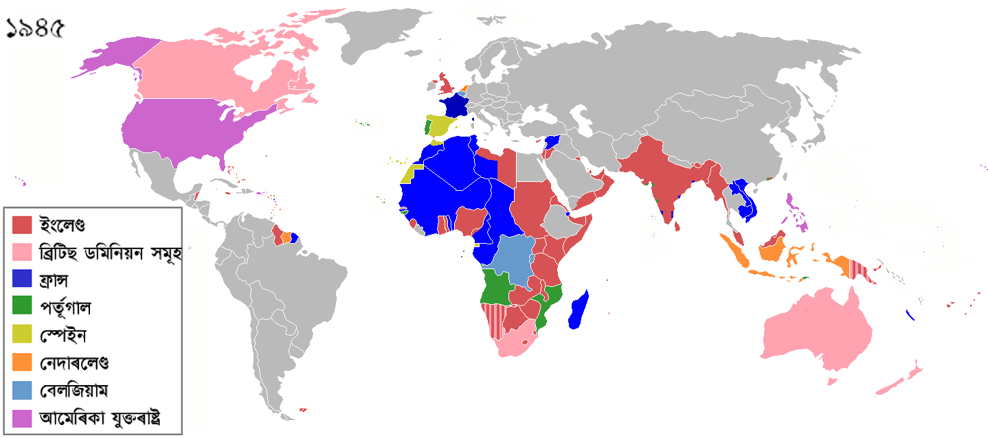
| DeskripsiColonization 1945 as.png |
The colors represent the colonies of various nations in 1945, and the colonial borders of that time. The derived file has the names of the countries in Assamese language. English: Colonisation in 1945 Español: Colonialismo en 1945 한국어: 1945년의 국가들 |
| Tanggal | (UTC) |
| Sumber |
This file was derived from: Colonization 1945.png: |
| Pembuat |
|
| Ini merupakan gambar hasil penyuntingan yang berarti bahwa gambar tersebut telah diubah secara digital dari versi asli. Perubahan: changed English country names to Assamese. Versi asli dapat dilihat di sini: Colonization 1945.png:
|
Lisensi
- Anda diizinkan:
- untuk berbagi – untuk menyalin, mendistribusikan dan memindahkan karya ini
- untuk menggubah – untuk mengadaptasi karya ini
- Berdasarkan ketentuan berikut:
- atribusi – Anda harus mencantumkan atribusi yang sesuai, memberikan pranala ke lisensi, dan memberi tahu bila ada perubahan. Anda dapat melakukannya melalui cara yang Anda inginkan, namun tidak menyatakan bahwa pemberi lisensi mendukung Anda atau penggunaan Anda.
- berbagi serupa – Apabila Anda menggubah, mengubah, atau membuat turunan dari materi ini, Anda harus menyebarluaskan kontribusi Anda di bawah lisensi yang sama seperti lisensi pada materi asli.
Log pengunggahan asli
This image is a derivative work of the following images:
- File:Colonization_1945.png licensed with Cc-by-sa-3.0
- 2012-08-26T14:08:03Z Hamodi1234 1438x638 (93790 Bytes) Fixed Brazil
- 2012-08-26T14:05:51Z Hamodi1234 1438x638 (93885 Bytes) Fixed Brazil and Syria
- 2012-07-24T14:04:22Z Soerfm 1438x638 (83090 Bytes) Legend
- 2012-06-09T09:14:44Z Ozzorro 1425x625 (46672 Bytes) Repositioned image and fixed colours to match other maps in the 'Colonisation' series (1492, 1550, 1660, 1754, 1800, 1822, 1885, 1914, 1938, 1959, 1974, 2007) - also corrected island positions. Suggestion: The 'British Domi
- 2012-06-09T09:10:31Z Ozzorro 1425x625 (46672 Bytes) Repositioned image to match other maps in the Colonisation series (1492, 1550, 1660, 1754, 1800, 1822, 1885, 1914, 1938, 1959, 1974, 2007), and also slightly modified colours and corrected island positions. The 'British Domi
- 2011-12-22T02:06:23Z Lemonade100 1356x674 (38879 Bytes) Reverted to version as of 00:46, 9 September 2011 as despite being memebers[sic] of the UN were still colonies of their respective imperial nations.
- 2011-12-03T08:47:28Z 23prootie 1356x674 (65062 Bytes) The [[:en:Philippine Commonwealth|Philippine Commonwealth]] and [[India]] were already members of the United Nations. They don't count.
- 2011-09-09T00:46:00Z SpencerCS 1356x674 (38879 Bytes) Independent Syria, corrected Cameroon, split British Somaliland from occupied Italian Somaliland.
- 2011-03-28T17:48:34Z Lemonade100 1356x674 (52448 Bytes) see below
- 2011-03-28T17:43:09Z Lemonade100 1356x674 (52448 Bytes) reverted to previous as AUS, CAN, NA and SA were considered Dominions at the time. Also, the British Parliament reatained the right to legilate on their behalf until the 1980s for AUS CAN and NZ; in 1960s for South Africa whe
- 2010-12-10T01:59:19Z Maps & Lucy 1357x628 (35364 Bytes) Reverted to version as of 12:09, 7 July 2008 Canada (excluding Newfoundland), Australia, New Zealand and South Africa had become Commonwealth Realms in 1931 therefore no longer being part of the British Empire!
- 2010-05-12T18:56:47Z Lemonade100 1356x674 (52448 Bytes) Added the British dominions (not yet independant) and their colonies.
- 2009-11-08T03:28:48Z Shipguy 1357x628 (23062 Bytes) {{Information |Description=== |Source=*[[:File:Colonization_1945.png|]] |Date=2009-11-08 03:26 (UTC) |Author=*[[:File:Colonization_1945.png|]]: Shipguy *derivative work: ~~~ |Permission=see below |other_versions= }} {{Retouc
- 2008-07-07T12:09:08Z Samulili 1357x628 (35364 Bytes) reverted to an earlier larger version
- 2008-05-21T04:03:09Z Pruxo 800x370 (75151 Bytes) {{Information |Description=aumento del contraste, anteriormente no se distinguían los continentes |Source=self-made |Date= |Author= [[User:Pruxo|Pruxo]] |Permission= |other_versions= }}
- 2006-12-22T06:02:16Z Roke 1357x628 (35364 Bytes) Reverted to earlier revision
- 2006-12-01T01:27:30Z Deltabeignet 1357x628 (50283 Bytes) Removed Newfoundland as per user request
- 2006-06-28T13:43:47Z Roke 1357x628 (35364 Bytes) remove italy and japan - defeated powers should not be shown in a 1945 map of colonialism
- 2006-05-13T22:03:47Z Yom 1357x628 (53540 Bytes) == Summary == '''Description''': Updated by [[en:User:Yom]] to correct the file created by [[en:User:Aris Katsaris]] (which was created to replace and partially correct the smaller[[:en:Image:800px_colonization_1945.png]] whi
- 2006-02-22T21:32:09Z Zinn 1357x628 (53390 Bytes) == Summary == '''Description''': Created by [[en:User:Aris Katsaris]] to replace and partially correct the smaller[[:en:Image:800px_colonization_1945.png]] which was in turn based on the different-languaged and improperly ext
- 2005-10-01T20:04:00Z Nuno Tavares 1357x628 (53479 Bytes) '''Description''': Created by [[en:User:Aris Katsaris]] to replace and partially correct the smaller[[:en:Image:800px_colonization_1945.png]] which was in turn based on the different-languaged and improperly extensioned [[:en
Uploaded with derivativeFX
Captions
Items portrayed in this file
menggambarkan
10 September 2012
image/png
checksum Inggris
05a839eeff0aab711769d62d7a166a2c7da5563d
3.679.161 Bita
638 piksel
1.438 piksel
Riwayat berkas
Klik pada tanggal/waktu untuk melihat berkas ini pada saat tersebut.
| Tanggal/Waktu | Miniatur | Dimensi | Pengguna | Komentar | |
|---|---|---|---|---|---|
| terkini | 20 Juli 2018 22.08 | | 1.438 × 638 (3,51 MB) | SuperSucker | UK |
| 10 September 2012 20.25 |  | 1.438 × 638 (90 KB) | উদ্দীপতালুকদাৰ | == {{int:filedesc}} == {{Information |Description=The colors represent the colonies of various nations in 1945, and the colonial borders of that time. The derived file has the names of the countries in Assamese language. {{en|Colonisation in 1945}} {{e... |
Penggunaan berkas
Tidak ada halaman yang menggunakan berkas ini.
Penggunaan berkas global
Wiki lain berikut menggunakan berkas ini:
- Penggunaan pada as.wikipedia.org
Metadata
Berkas ini mengandung informasi tambahan yang mungkin ditambahkan oleh kamera digital atau pemindai yang digunakan untuk membuat atau mendigitalisasi berkas. Jika berkas ini telah mengalami modifikasi, rincian yang ada mungkin tidak secara penuh merefleksikan informasi dari gambar yang sudah dimodifikasi ini.
| Resolusi horizontal | 28,35 dpc |
|---|---|
| Resolusi vertikal | 28,35 dpc |
| Tanggal dan waktu perubahan berkas | 20 Juli 2018 21.59 |