File:East-Hem_477ad.jpg
From Wikipedia, the free encyclopedia
Dimension de iste previsualisation: 800 × 470 pixels.Altere resolutiones: 320 × 188 pixels | 640 × 376 pixels | 1 024 × 601 pixels | 1 280 × 752 pixels | 3 240 × 1 903 pixels.
File original (3 240 × 1 903 pixels, dimension del file: 760 KB, typo MIME: image/jpeg)
Iste file proveni de Wikimedia Commons e pote esser usate per altere projectos. Le description de su pagina de description ibi es monstrate in basso.

|
This historical map image could be re-created using vector graphics as an SVG file. This has several advantages; see Commons:Media for cleanup for more information. If an SVG form of this image is available, please upload it and afterwards replace this template with
{{vector version available|new image name}}.
It is recommended to name the SVG file “East-Hem 477ad.svg”—then the template Vector version available (or Vva) does not need the new image name parameter. |
 | This historical map image was uploaded in the JPEG format even though it consists of non-photographic data. This information could be stored more efficiently or accurately in the PNG or SVG format. If possible, please upload a PNG or SVG version of this image without compression artifacts, derived from a non-JPEG source (or with existing artifacts removed). After doing so, please tag the JPEG version with {{Superseded|NewImage.ext}} and remove this tag. This tag should not be applied to photographs or scans. If this image is a diagram or other image suitable for vectorisation, please tag this image with {{Convert to SVG}} instead of {{BadJPEG}}. If not suitable for vectorisation, use {{Convert to PNG}}. For more information, see {{BadJPEG}}. |  |
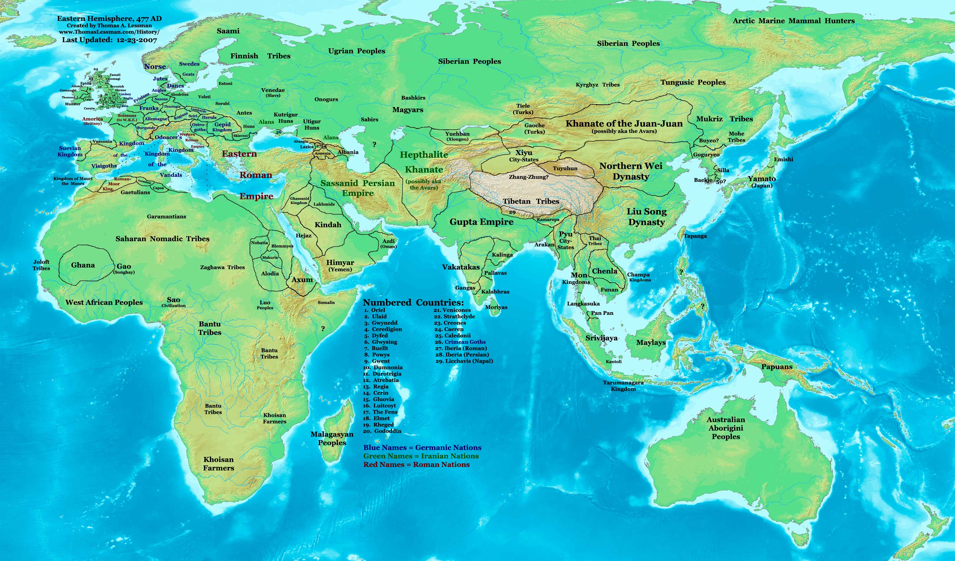
| DescriptionEast-Hem 477ad.jpg | Eastern Hemisphere in 477 AD. |
| Origine | self-made (For reference information, see the Map Source References section below.) |
| Autor | Thomas Lessman (Contact!) |
| Permission (Reuso de iste file) |
Io, titular del derecto de autor sur iste obra, declara de publicar lo sub le sequente licentia: Iste file es disponibile sub le licentia Creative Commons Attribution-CompartiSimile 3.0 Non localisate.
|
| Altere versiones | see East-Hem_477ad.jpg file history on Wikipedia. |
Contento
Registro de incargamento original
- 2008-01-30 21:43 Talessman 3240×1903×8 (771773 bytes) Updated version, many corrections and improvements
- 2007-07-21 20:25 Talessman 1973×1159×8 (2352310 bytes) Author: Thomas A. Lessman. Source URL: http://www.ThomasLessman.com/History/images/East-Hem_477ad.jpg. Image was created by me (Thomas Lessman) based on historical information located on Wikipedia, as well as information from maps located in Wikipedia and
Map Summary
Original Source URL: http://www.thomaslessman.com/History/images/East-Hem_476ad.jpg.
This map of the Eastern Hemisphere in 477 AD was created by Thomas Lessman, based on information from the sources listed below. This map is free for educational use (see Permission info above). When using this map, please mention that it is available for free at www.WorldHistoryMaps.info.
Map Source References
- Remember, sources often conflict with each other. This map is only as accurate as the information that is available to me. To report any errors or to help further this work, please click here, or email Thomas Lessman at talessman@yis.us
References for information contained in this map:
1. Borders of Europe are mostly derived from the Euratlas.com map of Europe in 500 AD.
2. Borders of Britain are derived from the "EarlyBritishKingdoms.com", map of map Britain in 475 AD.
3. Borders of Asian countries derive from various Wikipedia articles and Google history map searches.
4. Some information is derived from Wikimedia's map of The world in 500 CE, created by User:Javierfv1212.
5. Much of the information in this map was cross-checked with Bruce Gordon's Regnal Chronologies.
Other Maps in this Series
| Maps of the eastern hemisphere showing history
Bold dates are available on Wikimedia or Wikipedia. | ||
| Primeval | ||
| Ancient
|
·| 600 BC | 550 BC | 527 BC | 500 BC |
400 BC | ·| 1 AD | 50 AD | 100 AD | 200 AD | 300 AD | | |
| Medieval |
·| 500 AD | 565 AD | 600 AD | 700 AD | | |
| Modern |
·| 1500 AD | · * For historical maps of the whole world, | |
| history links talk edit view | ||
Legendas
Objectos representate in iste file
representa
Alcun valor sin elemento Wikidata
copyright status anglese
copyrighted anglese
Historia del file
Clicca sur un data/hora pro vider le file como appareva a ille tempore.
| Data/Hora | Miniatura | Dimensiones | Usator | Commento | |
|---|---|---|---|---|---|
| actual | 17:41, 9 maio 2008 | | 3 240 × 1 903 (760 KB) | Talessman | {{Information |Description=Eastern Hemisphere in 477 AD. |Source=self-made |Author=User:Talessman |Permission={{self|cc-by-sa-3.0}} }} |
Uso de iste file
Il non ha paginas que usa iste file.
Uso global de iste file
Le altere wikis sequente usa iste imagine:
- Uso in en.wikipedia.org
- Uso in rue.wikipedia.org
- Uso in sh.wikipedia.org
- Uso in sv.wikipedia.org
Metadatos
Iste file contine informationes additional, probabilemente addite per le camera digital o scanner usate pro crear o digitalisar lo.
Si le file ha essite modificate ab su stato original, es possibile que alcun detalios non reflecte completemente le file modificate.
| _error | 0 |
|---|