File:East-Hem_100bc.jpg
From Wikipedia, the free encyclopedia

Dimension de iste previsualisation: 800 × 470 pixels.Altere resolutiones: 320 × 188 pixels | 640 × 376 pixels | 1 024 × 601 pixels | 1 280 × 752 pixels | 3 240 × 1 903 pixels.
File original (3 240 × 1 903 pixels, dimension del file: 737 KB, typo MIME: image/jpeg)
Iste file proveni de Wikimedia Commons e pote esser usate per altere projectos. Le description de su pagina de description ibi es monstrate in basso.

|
This historical map image could be re-created using vector graphics as an SVG file. This has several advantages; see Commons:Media for cleanup for more information. If an SVG form of this image is available, please upload it and afterwards replace this template with
{{vector version available|new image name}}.
It is recommended to name the SVG file “East-Hem 100bc.svg”—then the template Vector version available (or Vva) does not need the new image name parameter. |
 | This historical map image was uploaded in the JPEG format even though it consists of non-photographic data. This information could be stored more efficiently or accurately in the PNG or SVG format. If possible, please upload a PNG or SVG version of this image without compression artifacts, derived from a non-JPEG source (or with existing artifacts removed). After doing so, please tag the JPEG version with {{Superseded|NewImage.ext}} and remove this tag. This tag should not be applied to photographs or scans. If this image is a diagram or other image suitable for vectorisation, please tag this image with {{Convert to SVG}} instead of {{BadJPEG}}. If not suitable for vectorisation, use {{Convert to PNG}}. For more information, see {{BadJPEG}}. |  |
|
|
This map image could be re-created using vector graphics as an SVG file. This has several advantages; see Commons:Media for cleanup for more information. If an SVG form of this image is available, please upload it and afterwards replace this template with
{{vector version available|new image name}}.
It is recommended to name the SVG file “East-Hem 100bc.svg”—then the template Vector version available (or Vva) does not need the new image name parameter. |
| This map image was uploaded in the JPEG format even though it consists of non-photographic data. This information could be stored more efficiently or accurately in the PNG or SVG format. If possible, please upload a PNG or SVG version of this image without compression artifacts, derived from a non-JPEG source (or with existing artifacts removed). After doing so, please tag the JPEG version with {{Superseded|NewImage.ext}} and remove this tag. This tag should not be applied to photographs or scans. If this image is a diagram or other image suitable for vectorisation, please tag this image with {{Convert to SVG}} instead of {{BadJPEG}}. If not suitable for vectorisation, use {{Convert to PNG}}. For more information, see {{BadJPEG}}. | |
| DescriptionEast-Hem 100bc.jpg |
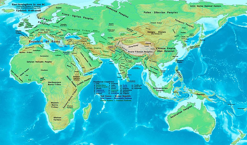
English: Eastern Hemisphere in 100 BCE. |
| Origine | self-made (For reference information, see below) |
| Autor | Thomas Lessman (Contact!) |
| Permission (Reuso de iste file) |
Io, titular del derecto de autor sur iste obra, declara de publicar lo sub le sequente licentia: Iste file es disponibile sub le licentia Creative Commons Attribution-CompartiSimile 3.0 Non localisate.
|
Contento
Map Summary
Original Source URL: http://www.thomaslessman.com/History/images/East-Hem_100bc.jpg.
This map of the Eastern Hemisphere in 100 BC was created by Thomas Lessman, based on information from the sources listed below. This map is free for educational use (see Permission info above). When using this map, please mention that it is available for free at www.WorldHistoryMaps.info.
Map Source References
(This section is being revised, please be patient!)
- Remember, sources often conflict with each other. This map is only as accurate as the information that is available to me. To report any errors or to help further this work, please click here, or email Thomas Lessman at talessman@yis.us
References for information contained in this map:
1. Borders of Europe are derived from:
- Roman Empire is well documented. Here are some of the better sources I used:
- * The DK Atlas of World History, 2000 Edition; map of Roman Conquests to 120 BC;(Page 179)
- * This map of the Phases of the Roman Empire by User:Varana.
2. Borders of Asia are derived from the following sources:
- Armenia borders derive from the map of the Armenian Empire, 95-66 BC under Tigranes the Great.
- Atropatene borders come from this map of the Armenian Empire, 95-66 BC under Tigranes the Great.
- Indo-Greek Kingdoms are derived from:
- * Wikimedia's map of the World in 100 BCE.PNG by User:Javierfv1212.
- Judea borders are derived from:
- * Wikipedia's article on the Hasmonean Kingdom,
- * This map of the Armenian Empire, 95-66 BC under Tigranes the Great.
- * This map of Israeli Borders, 167-76 BC (available on Livius.org).
- Kashmir under the Saka King Maues, is described on the Iranica.com article about the Indo-Scythians
- Mahameghavahanas are shown in Wikimedia's map of the World in 100 BCE.PNG by User:Javierfv1212.
- Palmyra borders are derived from Wikipedia's article about Palmyra, and from Wikimedia's map of the World in 100 BCE.PNG by User:Javierfv1212.
- Parthian Empire borders are derived from
- Persia borders are shown in the WorldHistoryMaps.com map of the old world in 036 BC archive copy at the Wayback Machine and their map of 150 BC.
- Pontus borders are derived from this map of the Armenian Empire, 95-66 BC under Tigranes the Great.
- Ptolemaic Kingdom
- Sakastan borders come from this map of Sakastan in 100 BC, available on Wikipedia's article on Sakastan.
- Satavahana Dynasty
- Seleucia borders are derived from this map of the Armenian Empire, 95-66 BC under Tigranes the Great.
- * Note: Seleucid rule over the "spur" of land west of Judea is derived from William R. Shepherd's map of The Growth of Roman Power in Asia (Asia Minor II).
- Sunga Dynasty
3. Fringe areas like Africa, Australia, Siberia, etc. are derived mostly from Wikimedia's map of the World in 100 BCE.PNG by User:Javierfv1212.
4. Much of the information in this map was cross-checked with Bruce Gordon's Regnal Chronologies.
Other Maps by Thomas Lessman
| Maps of the eastern hemisphere showing history
Bold dates are available on Wikimedia or Wikipedia. | ||
| Primeval | ||
| Ancient
|
·| 600 BC | 550 BC | 527 BC | 500 BC |
400 BC | ·| 1 AD | 50 AD | 100 AD | 200 AD | 300 AD | | |
| Medieval |
·| 500 AD | 565 AD | 600 AD | 700 AD | | |
| Modern |
·| 1500 AD | · * For historical maps of the whole world, | |
| history links talk edit view | ||
Other Information
Previous
Legendas
Objectos representate in iste file
representa
Alcun valor sin elemento Wikidata
copyright status anglese
copyrighted anglese
media type anglese
image/jpeg
Historia del file
Clicca sur un data/hora pro vider le file como appareva a ille tempore.
| Data/Hora | Miniatura | Dimensiones | Usator | Commento | |
|---|---|---|---|---|---|
| actual | 18:57, 9 augusto 2008 | | 3 240 × 1 903 (737 KB) | Talessman | {{Information |Description= |Source= |Date= |Author= |Permission= |other_versions= }} |
| 06:33, 16 maio 2008 |  | 3 240 × 1 903 (695 KB) | Talessman | Corrected borders of Korea, India, and Parthia. Added more info for central Asia. | |
| 15:02, 9 maio 2008 |  | 3 240 × 1 903 (699 KB) | Talessman | {{Information |Description='''Eastern Hemisphere in 100 BC'''. |Source=self-made |Author=Thomas Lessman |Permission={{self|cc-by-sa-3.0}} }} |
Uso de iste file
Il non ha paginas que usa iste file.
Uso global de iste file
Le altere wikis sequente usa iste imagine:
- Uso in als.wikipedia.org
- Uso in ar.wikipedia.org
- Uso in ast.wikipedia.org
- Uso in azb.wikipedia.org
- Uso in az.wikipedia.org
- Uso in ban.wikipedia.org
- Uso in bar.wikipedia.org
- Uso in bcl.wikipedia.org
- Uso in bg.wikipedia.org
- Uso in bs.wikipedia.org
- Uso in de.wikipedia.org
- Uso in el.wikipedia.org
- Uso in en.wikipedia.org
- Gerrha
- Hellenistic period
- Indo-Scythians
- Shunga Empire
- Kingdom of Armenia (antiquity)
- Classical demography
- User:Tompw/sandbox10
- Qataban
- Oddiyana
- User:Talessman/Maps
- User talk:Talessman/Maps
- Timeline of ancient history
- User:Benjamin Trovato/sandbox
- Transjordan (region)
- List of Classical Age states
- Aorsi
- User:Falcaorib/Ancient East Hemisphere
- Uso in es.wikipedia.org
- Uso in fr.wikipedia.org
- Uso in ga.wikipedia.org
- Uso in gl.wikipedia.org
- Uso in he.wikipedia.org
- Uso in hu.wikipedia.org
- Uso in hy.wikipedia.org
- Uso in hyw.wikipedia.org
- Uso in mk.wikipedia.org
- Uso in ml.wikipedia.org
Vider altere usos global de iste file.
Metadatos
Iste file contine informationes additional, probabilemente addite per le camera digital o scanner usate pro crear o digitalisar lo.
Si le file ha essite modificate ab su stato original, es possibile que alcun detalios non reflecte completemente le file modificate.
| _error | 0 |
|---|